


What's New In SuperMap iDesktopX 11i (2022)
The SuperMap iDesktopX 11i (2022) desktop product includes the following new features and optimizations over the previous release:
Data Management
- The Calculate Geometry Attributes adds the area of the calculated ellipsoid.
- New Mosaic Dataset Inspection and Optimization :
- Check whether the Check Mosaic Dataset is block storage, whether the Pyramid is Created, and whether the Compression method is set.
- Optimization: If Mosaic Data is not block storage, does not Create Pyramid, and does not set Compression method, you can directly optimize the data.
- Optimize the Mosaic DatasetCreate Pyramid and add Bilinearity, Cubic Convolution and other Resampling Methods.
- A new Send streaming data tool is added to interface with the iServerStream service.
- Optimize the Coordinate System Settings function. The predefined coordinate system supports the Scope of application for viewing the coordinate system.
Data Editing
- Added Plot the geodesic function to draw a line between two points on the surface of the ellipsoid.
- Optimize the Fill Gap feature to support batch Fill Gaps to specified objects by drawing faces that cover single or multiple gaps.
Data Processing
- Optimize the Extract Centerline from Two Lines , support the measurement and calculation of line width on the map, and set the maximum and minimum line width according to the measurement and calculation value.
- Add the Extract Outline function to support the extraction of the outlines of images, grids, and Mosaic Dataset.
- Update Raster Value function is added , which supports updating the grid value in the Specify Range to the target value.
- Merge Datasets function is added to support converting multiple Merge Datasets of the same type into one Dataset.
- Remove Duplicate Objects function is added to delete Duplicate Objects with consistent positions and specified attributes in point, line and Region Dataset.
- Optimize the update column function, and support the update through enumeration value and enumeration description.
- Add an attribute table Field Segmentation Operations , and reclassify the existing field value to a new value field according to the segmentation method and segment number.
- A new Topology Checker is added to quickly process the checked Topology errors:
- The
- checked Topology error list is displayed in association with the map, and the Topology error in the map can be located through the list;
- Support filtering and displaying the corresponding Topology error according to the specified Topology Error Type;
- Support quick processing of Topology error through the functions of Crop, Erase, Create Features and Mark Exception of Context Menu.
Map Cartography
- Optimize the Map magnifying glass function, the position of the magnifying glass follows the mouse hover, and provide shortcut keys for zooming in, zooming out, and customizing the magnification.
- Layer Style Copy function is added to support quick copying of the style of the specified layer to other layers.
- Optimize the Custom Legend function, and add Display Effects that supports displaying only the first-last Label.
- Plug- in Symbol Library Management function is added to support direct reading and use of symbols in external symbol library files without importing them to the Current Works pace. And that redundancy of the current Works pace Resources is reduce.
- The new Label Matrix Thematic Map uses the matrix format to carry the rich annotation content. The symbols, pictures and texts can be integrated into a Label Matrix, and then the corresponding objects can be annotated.
- Optimize the Thematic Label Map and add support for four label Display Control effects:
- Show Extra Line Label: a label with a length 1-2 times
- the length of the line object can be displayed;
- Label in-plane flat display: the label display direction is parallel to the long side of the face object Bounds;
- Show
- only In-region Labels: Hide labels outside the object;
- Remove duplicate labels: The duplicate display function of Compound can be removed to remove redundant labels.
- Unique-values Map supports moving up and down to adjust the order of single-value items. After adjustment, the legend order is consistent with that of single-value items.
- Support Set Text Layer and Thematic Label Map Layer Weight , and control the layer Display Order according to the weight value.
- Increase the scale Numerical Precision to 20 decimal places.
- It improves the efficiency of large-scale map output TIF files with large range and high DPI, and the output TIF files adopt LZW compression Encode Type, which greatly reduces the disk space occupation.
Map Tiles
- Optimize Generate Map Tiles capabilities:
- The Projected Coordinate System Image Map supports setting the basic scale to cut the map, and efficient cutting based on the original scale of the image.
- When a vector map generates a Raster Tile, the blank area of the map is automatically excluded when the map cutting task is constructed, so that the Tile generation efficiency of the map with a large blank area is improved.
- Generate Map Tiles by Multiple Tasks supports reducing the granularity of task splitting according to the estimated number of tasks, which can effectively reduce the waiting time of task splitting and quickly enter the graph cutting process.
- Support Browse the cut Vector Tile on the desktop and facilitate Check TilesDisplay Effects.
- Optimize the Tile check function to support checking whether there are extra tiles outside the boundary.
- TileType Conversion function is
- added to support the mutual conversion among MongoDB Tile, Local Original Tile and Local Compact Tile.
- Optimize Extract Tiles , Support extracting the Tile of Specify Range and scale bar in MongoDB Tile, Local Original Tile, and Local Compact Tile as a Tile of any type.
Layout
- The Refresh Map function is added to the
- layout. When the map display content and display style are changed, the map Display Effects in the layout can be synchronized through the Refresh Map function.
- Optimize Layout Manager , support element Renames.
Spatial Analysis
- Barrier Splines Interpolation Analysis function
- is added , which supports specifying Line Dataset as obstacle data, and the data on both sides of the obstacle line is discontinuous after interpolation. It is suitable for data interpolation of cliffs and blocked faults.
- Optimize Profile Analysis Features
- Support Profile Analysis for Draw Line ;
- Support real-time viewing of Profile Analysis results, and the results can be Export as Image;
- Support map-related display of sampling points, and the sampling points in the result chart can be displayed in the map in real time;
- Support the maximum and minimum values of user-defined Y axis;
Network and Traffic Analysis
- By optimizing the Service Area Analysis function, the Analyst Result will generate reachable circles along the direction, and the results will be more accurate.
- Optimize the Query the M value function to support the query of route points and line objects with the specified M value.
Geo-Processing Automation (GPA)
- Model building and execution
- New ability to edit and view Model metadata .
- Support Create Group, which can manage the tools in the model in groups, simplify the display of complex models, and increase the readability of the model.
- Add the function of executing to this node and starting to execute from this node. Set Model can be executed to the specified tool node, and then executed from the specified tool node to the last tool node.
- Optimize the cancellation function and support immediate cancellation in the execution process.
- Optimize Conditional filtering and support setting the condition type to Else.
- Optimize Variables :
- Variable List is added to display and manage all variables of the current model in the form of a list, which is convenient for viewing and modifying the values of all variables in the model.
- Support the connection of variables as Pre-condition, and different condition types can be set according to different additional Property Settings of variables.
- Optimize Log Information, add the result of in-row variable substitution and the actual spark environment parameter information, and remove the progress information in the log file.
- Toolbox
- A new favorite function is added to facilitate the collection of common functions.
- Added Recently used tools list for quick access to common tools.
- FME Grouping is added to support FME (Feature Manipulate Engine) docking . FMEWorkspace (.fmw) can be added as a Geo-Processing Automation (GPA) tool, which can be used in conjunction with other tools in modeling to achieve organic integration with FME.
- Extraction of new data element information-& gt; The Scan Folder tool is used to extract the meta-information of the data in the Workspace file and UDBX/UDB file under the specified folder, including the name, coordinates, projection, and range of the data, and store the extracted meta-information in PostGISDatasource.
- Optimize the Vector Analysis-Overlay Analysis tool: support the calculation of inputting or outputting unrecorded Dataset; add the parameters for saving all fields of source data and Overlay Data
- Spatial Statistical Analysis module adds K-means clustering, Mean shift clustering , Spatio-temporal geographically weighted regression tool.
- Geometry check and Geometric repair are added to Topology Module. Used to check Geometry for geometry problems and fix them.
- Raster Mosaic tool added to
- Data Processing grid module.
- Added Equal Resampling tool to the
- Data Processing grid module.
- Data Processing vector module adds Protective Decomposition , GeoSOT 2D encoding , GeoSOT 3D coding、Two-dimensional coding of geographic entities、 Three-tools such as dimensional coding of geographic entities .
- Line trajectory similarity measure is added to the
- big data Vector Analysis module. Point trajectory similarity measure tool.
- Geographically Weighted Regression Analysis tools are added to the
- big data Vector AnalysisMachine Learning module.
- Equal Resampling tool is added to the
- big data Raster AnalysisData Processing module.
- Four new Image Stretching tools are added to
- the big data Raster AnalysisData Processing module: Image Minimum Maximum , Image Standard Deviation、Image Histogram Equalization Stretch、 Image Percent Clip。
- Specify a value count tools are added to the
- big data Raster AnalysisRaster Statistics module.
- The big data Raster Analysis Surface Analysis module adds Extract All Isolines , Extract Specific Isolines。
- The Curvature calculation tool is added to the
Video Map
- Optimize the video stream function and newly support the video stream data of HLS (m3u8), RTMP, HTTP and HTTP-FLV protocols.
- Optimize the Flight Record Conversion tool to support capturing the Camera Parameters of the specified video duration in the *.dat flight record file of DJI UAV for Video Registration.
- Camera Parameters position offset tool is added. If there is an offset between the camera point and the target point, the Camera Parameters can be offset as a whole according to the specified offset.
- Optimize the rendering effect of Video Map window overlay display. Video overlay with hundreds of thousands of Vector Data can render smoothly.
- After optimizing the Video and Map Associated Browse, the Video window and MapAssociated Browse, the Map Visible Bounds: will move with the Video Scene location to ensure that the Video Scene is displayed in the Map.
- Support Output Video as Pictures, which can Export as Image video frames according to the specified time interval, so as to facilitate the production of Video Analysis samples based on pictures.
- Optimize the Video Enhancement function, support the image, GIF, video Add to Video of the specified location, such as dynamic landmarks, pointing arrows, ground landmarks and other objects, to improve video readability.
- The new Generate Image Dataset function supports the access to the photos taken by the UAV, reads the Position Info of the pictures, imports them into Image Data and automatically registers them.
Video Analysis
- Optimize the Video AnalysisPredefine Model and add Detect Broken Roads model and Yolo V5 series model.
- The Probability Threshold of Video Analysis category can be set. For example, when the Probability Threshold is set to 0.6, Detection result does not retain a detection result with probability ≤ 0.6.
- Support the setting of IOU threshold of Video Analysis results. If the IOU between Detection results is greater than threshold, it indicates that the identification object is the same, and only one Detection result is reserved; If the IOU is less than threshold value, it indicates that different objects are detected. Detection result will keep multiple.
- The Release Detection Process function is added. After multiple video windows are opened and detection is enabled, and then the video window is closed, there will be multiple detection processes, which will occupy the video memory. If Video Detection is performed again, other idle detection processes can be released actively. Otherwise, the detection performance may be affected.
- Optimize the Display Effects of the detection box in Video Analysis, and optimize the text background for the bubble effect.
- Optimize the Detection Result Settings function, and support the setting of the background and Text Style of the Detection result. After the background style is set, the text will Invert colors automatically.
Machine Learning
- Optimize the Export Image sample library function to support the export of samples to the sample library for YOLO v4 and YOLO V5 models.
- Add the function of automatically generating image sample library. The specified image can be based on the target in the existing Model File and Auto Label images, and Generate Sample Library.
- Add AI Label function, click the target with the mouse to Auto Label the shape of the target, and support automatic adjustment of the labeling range of the target.
- Optimize the Generate Training Data function and support the generation of sample library suitable for Detect Common Change based on image samples.
- Optimize the Model Training function of Imagery Analysis to support the training of models suitable for Detect Common Change.
- Video Model Training function is added to support the training of video Object Detection model based on YOLO V5 algorithm.
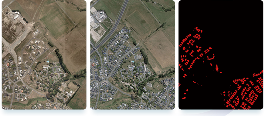
- A new Detect Common Change function is added, which can detect the area where the ground cover changes in two images.
Data Migration
- Optimize the Migrate Tile function to support the migration of ArcGIS map slices to SuperMap.
- Optimize the import of shapfile data, and support the import of multiple *.shps into one Dataset.
- Optimize Map Migration functionality:
- Support the migration of the text annotation layer to Text Dataset;
- Support the migration of filtering display expressions in Layer Properties;
- Support the parsing of the association table set in the layer;
- Rotation angle that
- supports migration of Unique-values Map symbols.
3D Scene
1. 3D Data
- Optimize Generate in Bulk model cache function: Texture Compression format removes ETC, no compression, PVRTC, and adds KTX2.0 compression format.
- Optimize the warehousing function of Oblique Photography Model: support the setting of parameters such as normal and root node coloring type; remove ETC, non-compression and PVRTC in Texture Compression format, and add KTX2.0 compression format.
- Optimize the function of 3DTile to S3m: ENU is changed to the parameter of Ellipsoid to Ellipsoid sphere, and Ellipsoid to Sphere is supported.
- Optimize the Model Flatten function: the Import Flatten Surface supports the field value marking character.
- Optimize the vector face Strech Generate model cache function: support the setting of material type.
2. 3D Geographic Design
- Optimize Edit Material function: support batch editing of materials.
- Optimize Linear Extrude functionality: Support setting Texture Field.
3. Data Processing
- Optimize the generation of TIN cache function: support the setting of Preserve Precision parameter, and check whether the generation of TIN Terrain retains higher precision.
- Optimize the build model caching feature:
- Support the setting of sphere type;
- Texture Compression format removes ETC, no compression and PVRTC;
- Support the setting of parameters such as material type, secondary texture type, and sphere type;
- Material types include Common Material, PBR Material, UE, and Unity Material;
- The second texture type includes Shadow Texture and Selt-luminous Texture.
4. Scene
- Support 3D Marker creation and editing.
- Support the creation and editing of 3D Filling Symbol.
- Support the creation and editing of 3D linetype symbols.
5. Tools
- Oblique Import: Added Generate Normal function.
- TIN: TIN append function is added.
- Model: Added Batch BIM in Library functionality.
- Model: Generate in Bulk same-name model cache function is added.
- Model: Add the function of saving the model cache to the layer group.
- New Data Import module: supports importing *.ifc and *.3dxml data.
- AI extraction: Optimize Model window self-illumination function: Support the setting of material types, including Common Material and PBR Material.
Secondary Development
- Construct Secondary-Development Project function is added to quickly create a Secondary Development project in an interactive manner.
Interactive experience
- Added Short cut Key Management function
- Support setting of function shortcut keys;
- Support the modification of the original shortcut key of the function;
- Support the import/Export shortcut configuration file, which can quickly configure the desktop shortcut key to other computers.
- Optimize Data Import mode:
- Data opened in File Database mode is
- supported. When it is dragged to the Datasource node, the import window will pop up automatically.
- Data opened in File Database mode
- is not supported. Drag it to the desktop, and the import window will pop up automatically.
- Desktop Environment Variable setting function is added, which can view and modify the Environment Variable when the desktop is running.
Interface change list
PackageName adds the following interface list to the com. Supermap. Desktop. Controls:
ClassName MethodName SmOptionPane showCustomURLMessageDialog(String,String,ActionListener) setWrapStyleWord(boolean) getWrapStyleWord() SmTextStyleItalicAngleComponent setItalicAngleValue(double) getItalicAngleValue() SmLabelURL setClickedActionListener(ActionListener) SmPanelShrinkable SmPanelShrinkable(String,JComponent,Insets,int) SmDialogProgress setLabelRemainTimeVisible(boolean) setButtonCancelText(String) SmDialogProgressTotal setButtonCancelVisible(boolean) setLabelRemainTimeVisible(boolean) SmPanelHelpProvider getIconWidth() WarningOrHelpProvider setLineFeedLength(int) getLineFeedLength() SQLExpressionDialog SQLExpressionDialog(JFrame) SQLExpressionDialog(JDialog) NumberFieldLegit NumberFieldLegit(String,boolean) isShowSpinnerButton() setShowSpinnerButton(boolean) getStepSize() setStepSize(double) SmTextFieldLegit checkTextFieldState() SmToolbarMenu setShowFunctionIcon(Icon) getShowFunctionIcon() LayersTree setSelectedPathByNames(String) UICommonToolkit showMessageDialogWithURL(String,String,String) showMessageDialogWithCustomURL(String,String,ActionListener) showErrorMessageDialog(JDialog,String) showConfirmDialogYesNo(JDialog,String) isShowDialog() setShowDialog(boolean) DatasourceOpenUtilities openArcGISCacheDatasource(File,boolean,Workspace) createMemoryDatasource(Workspace,String) refreshDatasource(Datasource) MapViewUIUtilities openSciFileToForm(String) NodeDataTypeUtilities isThemeNodeItem(NodeDataType) PackageName adds the following interface list to the com. Supermap. Desktop. Core:
ClassName MethodName IForm Tabular getSelectedModelColumn() getSelectedModelColumns() getJScrollVerticalBarValue() setJScrollVerticalBarValue(int) BrowserUtilities openURLInBrowser(String,String) CursorUtilities setGlassWaitCursor() unSetGlassWaitCursor() DatasetUtilities closeDatasetAndRemoveLayer(Dataset) closeDatasetAndRemoveLayer(Datasets) DatasourceUtilities closeDatasourceAndKeepLayer(Datasource) closeDatasourceAndRemoveLayer(Datasource) compactDatasource(Workspace,Datasource) DateUtilities compareToMinute(Date,Date) get24HFormatDataString(Object) get24HFormatDateStringNet(Object) parseDateString(String) EngineTypeUtilities getAllFileEngineTypes() GeometryUtilities boundsConvertToGeoRegion(Rectangle2D) ImageUtilities getDesktopLogo() crop(BufferedImage,Rectangle2D) copyImage(BufferedImage) PythonUtilities setPythonExecutor(IPythonExecutor) SymbolUtilties addSymbol(Resources,SymbolGroup,Symbol) cloneSymbol(Symbol) WorkflowUtilities getAvailableWorkflowName(String,boolean) getSplitFieldNames(String) encryptDataProperty(IWorkflow,boolean)