


Feature Description
Resampling is an operation to alter the resolution of raster datasets, which can be categorized into upsampling and downsampling based on resolution changes. Upsampling refers to reducing cell edge length and increasing cell quantity, while downsampling increases cell edge length and decreases cell quantity. During upsampling, when the exact edge length value is uncertain, users can specify equal division counts to partition raster edges (e.g., 2-equal division, 4-equal division, 6-equal division). This process is called equal resampling.
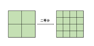
As shown in the diagram above, the right-side raster results from 2-equal division resampling of the left-side raster's edges.
Application Scenario
When resampling a 30m resolution geographic coordinate system raster to 10m resolution, converting cell size from meters to degrees may encounter non-integer division scenarios requiring decimal precision. Equal resampling solves the problem of manual imprecision in meter-to-degree conversion calculations.
Parameter Description
| Parameter | Default | Description | Type |
|---|---|---|---|
| Source Raster Data | Input raster data for resampling (supports imagery) | Dataset | |
| Division Count | 2 | Number of equal divisions for original raster edges (must >1) | Int |
| Resampling Method | Nearest Neighbor | Available methods: Neatest Neighbor, Bilinear Interpolation, Cubic Convolution Interpolation | ResampleMode |
| Target Datasource | Output datasource for results | Datasource | |
| Result Dataset Name | Name for output dataset | String |