


Feature Description
The Extract Tiles feature enables tile data distribution management through specified scales and custom extraction boundaries. It facilitates large-scale tile data extraction by defining target areas and tile scales, eliminating cumbersome clipping and extraction processes.
For instance, when a province needs to distribute high-resolution image data to regional administrations, simply using administrative boundaries as extraction boundaries can directly extract tiles for corresponding areas. Users may also specify extraction scales to constrain data precision levels during extraction, enabling efficient data distribution without retiling.
Feature Entry
- Data Tab->Manage Tiles Group->Manage Tiles.
Steps
- Add Target Tiles: Add MongoDB tiles or local tiles. For detailed operations, refer to Add Tiles.
- Extract Tiles: Click the Extract button in the Manage Tiles panel toolbar to open the Extract Tile dialog. Configure parameters as follows:
- Tile Name: Select target tiles from the dropdown, defaulting to the first record in the Manage Tiles list.
- Scale: Check desired scales from the current map tiles' scale list.
- Extract Bounds: Configure extraction boundaries using four methods: Whole Map, Current Window, Custom Bounds, or Copy-Paste Range. For detailed descriptions, see Generate Map Tiles--Tile Bounds.
When using Select Object boundary setting, ensure the boundary polygon layer is added to the current Manage Tiles window. The application will use selected object's bounds as extraction boundaries.
- Result Settings: Select storage type: Origin, Compact, or MongoDB. Configure accordingly:
- For Origin/Compact formats: Specify output directory and tile name.
- For MongoDB: Configure server address, database name, tile name, username, and password.
- Enable Multi-threading: Enabled by default. Default thread count is determined by CPU cores: (cores ≤16: cores-1; cores >16: cores-2). Adjust thread count based on system resources to optimize performance.
- Click OK to execute extraction after configuring parameters.
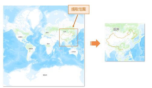
- The example below shows extracting China region tiles from global shaded relief data. Original scales were selected, with boundaries set via Select Object (national border polygon) or Draw Rectangle. Final results are shown as:
Related Topics