


Check Tiles
Feature Description
The Check Tiles feature identifies issues such as white blocks, white lines, missing tiles, and corrupted tiles within specified check ranges in GeoJSON format or dataset format. It facilitates timely detection and correction of erroneous tile data, supporting inspection of raster tiles stored in Compact or MongoDB formats only.
Feature Entry
- Data Tab -> Manage Tiles Group -> Check Tiles.
- Maps Tab -> Cartography Group -> Map Tiles -> Check Tiles.
- Right-click map and select Check Tiles.
Parameter Description
- Compact Tile: Select this option and input the SCI file path in the right text box.
- MongoDB...: Check this option and add MongoDB tiles through the "+" button.
- Check Range: Define inspection scope in GeoJSON format or dataset format (region dataset only).
- GeoJSON Format: Export range data to GeoJSON file using Data Export functionality.
- Dataset Format: Select region dataset from datasource as check range.
 Note:
Note:Check range coordinates must align with tile coordinates.
- Check Levels: Set scale levels to inspect (default: all levels).
- Process Count: Configure parallel processes (default: CPU threads-1 when ≤16, otherwise threads-2).
- Output Directory: Specify export path for check reports.
- Check Items: Enable inspection types through checkboxes: Missing Tile, White Tile, Black Tile, Transparent Tile, Out-of-Bounds Tile, White-Line Tile, Black-Line Tile.
- Custom Color Checks: Add/remove other color checks:
Click "+" to add entries. Configure color and check type (Line/Block). Multiple entries allowed. Use "-" to delete invalid entries.
-
Result Interpretation:
Results contain two folders:
- cacheCheck: Stores task directories, logs, and SCI file info.
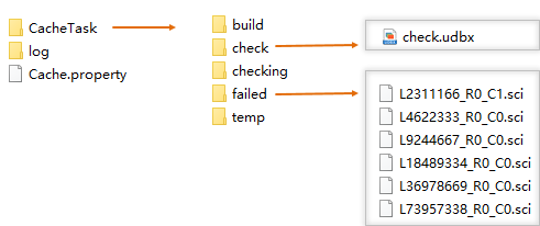
- CacheTask: Subdirectories for task management - build (SCI files), check (verified bounds), checking (active tasks), failed (errors), temp (temporary files).
- log: Operation logs.
- Cache.property: Tile storage format details.
- TileCheckResult: Contains inspection results:
- boundaryData.udbx: Boundary region dataset.
- checkLog.csv: Error log in CSV format.
- errorData.udbx: Error tile records with fields:
- tilerow: Tile row index.
- tilecol: Tile column index.
- errorType: Error classification.
- tilePath: Storage path (empty for MongoDB).
- TileCheckResult.smwu: Workspace with maps and error datasets.
Error Tile Remediation
For detected errors:
- Verify if errors exist in original map (e.g., legitimate black features).
- If map contains genuine features, regenerate tiles for affected scales and ranges.
- Ensure Windows display scaling is set to 100% during tile generation to prevent rendering artifacts.
Related Topics