



The Advanced options in the Thematic Map panel are mainly used to control the display of labels in the current label thematic map.
Label Along Line
The parameters in the Label Along Line area are used to control the display effects of labels in a line label thematic map. The involved parameter descriptions are as follows:
- Fixed Text Angle: If this check box is selected, the text within the label objects in the label thematic map will always maintain a vertical direction.
- Remove Duplicate Labels: After checking this check box, the complex line objects will be preprocessed, and multiple connected objects with the same name will be treated as one object for labeling. If not checked, these objects will be labeled separately.
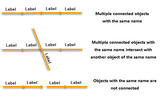
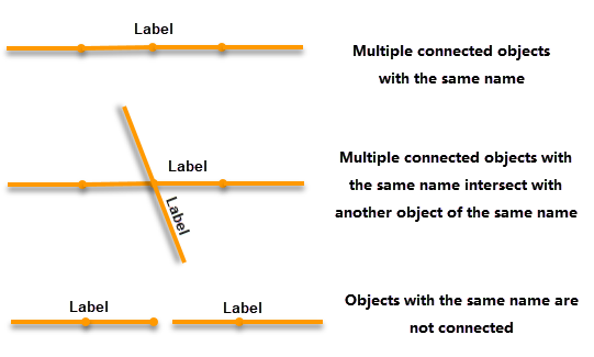
Figure: Remove Duplicate Labels unchecked Figure: Remove Duplicate Labels checked  Note:
Note:- When generating vector tiles, the Remove Duplicate Labels setting is invalid;
- If the label expression uses a joined property field from a linked table, the Remove Duplicate Labels setting is invalid.
- In a label thematic map, if the label expression uses a complex composite expression (e.g., NAME [/] 'Length:' || SHAPE_Leng), applying the "Label Along Line" style is currently not supported.
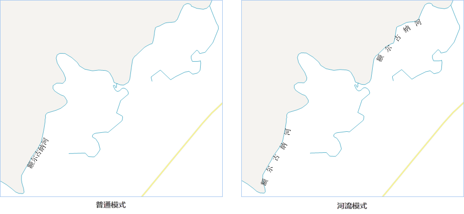
- Along Line Mode: To ensure good display effects for label thematic maps in different usage scenarios, the application provides Normal Mode and River Mode.
- Normal Mode: Suitable for labels of point and region data, such as annotations for place names or attribute values.
- River Mode: Suitable for annotating river line data. In this mode, labels can be displayed evenly along the river, avoiding situations where river labels appear too small. The text display direction is reasonable, and labels are not placed in areas with many or sharp bends, resulting in a uniform and aesthetically pleasing distribution of river labels.
- Along Line Display Direction: Used to set the direction of the text label along the line. The application provides five methods:
- Along the Normal of the Line: Labels along the line direction from the start point to the end point;
- Top to Bottom, Left to Right: For vertical lines, labels display from top to bottom; for horizontal lines, labels display from left to right;
- Top to Bottom, Right to Left: For vertical lines, labels display from top to bottom; for horizontal lines, labels display from right to left;
- Bottom to Top, Left to Right: For vertical lines, labels display from bottom to top; for horizontal lines, labels display from left to right;
- Bottom to Top, Right to Left: For vertical lines, labels display from bottom to top; for horizontal lines, labels display from right to left;
Note:- When using this function, the system automatically determines whether the line's orientation is horizontal or vertical. The criterion is: connect the start and end points of the line. If the angle between this line and the horizontal direction is less than 60 degrees, the line is considered horizontal; otherwise, it is considered vertical.
- If the Fixed Text Angle check box is selected, the settings in the drop-down button to the right of the Along Line Display Direction control are invalid;
- If you set the Along Line Display Direction and then check the Fixed Text Angle or modify the Along Line Word Spacing, overlapping characters may occur due to spacing issues, causing some labels not to be displayed.
- Along Line Word Spacing: Used to set the interval distance between characters in the label text, with the unit being a multiple of the character height. The value range is [1, 8]. For English words and numbers, spaces are used to determine whether it is a word or a number. For example, "SuperMap" and "12325" represent one word and one number. If it is "SuperMap" and "123 25", it represents "SuperMap", "123", and "25", i.e., two words and two numbers, which will be displayed at the specified along-line word spacing at the spaces.
- Relative Angle Between Characters Along Line: Sets the maximum angle between adjacent characters or letters to ensure the aesthetics of the label along the line. The value range is [0, 90]. The smaller the angle tolerance value, the more compact the label, but labels may not be placed in areas with sharp bends; the larger the angle tolerance value, the more likely labels can be displayed in sharp bend areas, but the aesthetics of the label along the line will decrease. Therefore, considering map aesthetics, it is recommended to preliminarily calculate an appropriate angle value when setting this parameter. The relative angle between characters or letters in a label along the line is shown in the figure below:

- Period Interval Unit: Used to set the unit for the period interval value of the label along the line. Click the drop-down button on the right and select Unit or 0.1mm from the pop-up drop-down menu as the period interval unit. 0.1mm indicates that the label period interval is measured in units of 0.1mm; Unit means the set label period interval is consistent with the unit of the map's coordinate system.
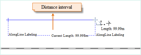
- Along Line Period Interval: When a line object is too long, it can be labeled at intervals. The text box to the right of this control is used to set the distance for repeated labeling. Note that the period length set here refers to the distance from the end of one label text to the beginning of the next label text. As shown in the figure below, a section of railway is labeled with an along-line word spacing of 1 time and an along-line period interval of 100. Then, measuring the distance from the end of any label text to the beginning of the next label text yields exactly one along-line period interval, with a length of 100. The unit is consistent with the map unit.
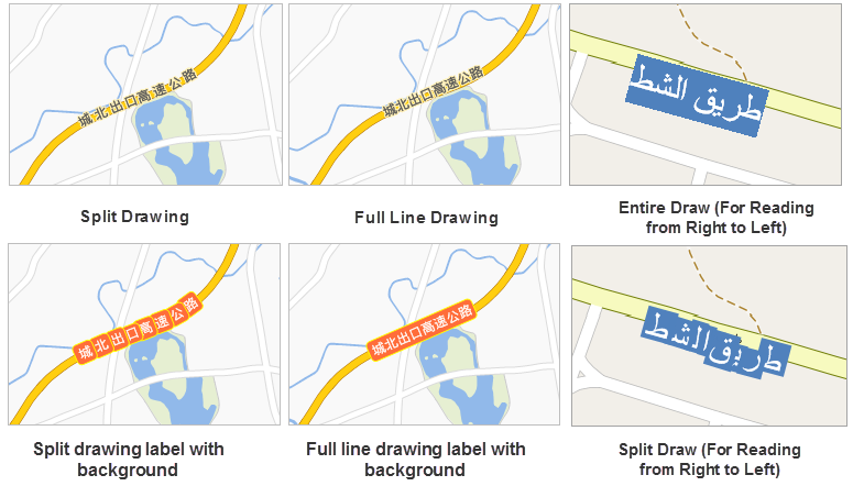
- Drawing Type: Sets the drawing strategy for drawing along the line, providing five drawing methods:
- Compatible Draw: Starting from SuperMap GIS 8C(2017), the drawing strategy for standard along-line labels has been adjusted. If the thematic map was created with a previous version and you want to display the original thematic style, it is recommended to select the "Compatible Draw" option.
- Entire Draw: Draws the label as a whole, generally applied to labels with backgrounds along the line.
- Split Draw: Draws the text and letters in the label separately. Using Split Draw, the label will closely follow the trend of the labeled line.
- Entire Draw (for "Right->Left" Reading Text): Draws the label as a whole displaying from right to left, suitable for text read from right to left, such as Arabic. When using this drawing method, the label font must be set to a Western font, such as Times New Roman, and the Along Line Display Direction must be set to Along the Normal of the Line; otherwise, the label will produce incorrect display effects with this drawing method.
- Split Draw (for "Right->Left" Reading Text): Draws the text in the label separately, suitable for text read from right to left, such as Arabic. When using this drawing method, the label font must be set to a Western font, such as Times New Roman, and the Along Line Display Direction must be set to Along the Normal of the Line; otherwise, the label will produce incorrect display effects with this drawing method.
- Show Overlapping Objects: Check this check box to show labels of overlapping objects, enhancing map readability.
- Display Overlong Label: Used to control the display of labels whose length exceeds the line length. Check this check box to display labels whose length does not exceed a specified multiple of the line length; the default is 2 times the length of the labeled line object. If unchecked, the maximum displayable length of a label is the length of the line object. For example, if there are many line objects with long names but short lengths in a river line dataset, these labels will not be displayed if this option is not checked when creating a label thematic map.
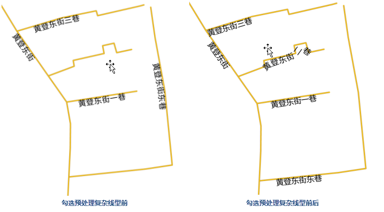
- Preprocess Complex Line: Check this check box. As shown in the figure below, labels can be displayed in areas with high curvature, and labels whose document length is greater than the length of the labeled line segment can be displayed.
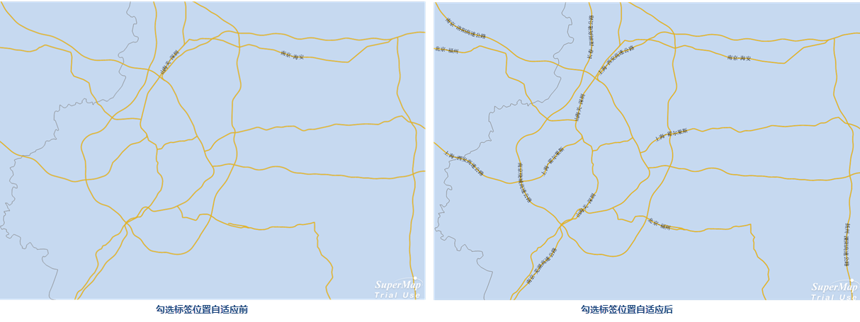
- Adapt Label Position: Check this check box, and the application can automatically select appropriate positions on the object for labeling, avoiding labels all appearing at the object's center and causing overlap.
- The Text Order Is Consistent with the Line Direction: Specifies that the display order of the label text is consistent with the direction of the line object.
Label Length Settings
 Warning:
If the Label Along Line function is enabled, only single-line display is supported for text characters, and other settings are invalid.
- Overlength Processing Method: Used to set the display method for overlong text labels. The system provides four processing methods: Single Line Display, New Line (Hide the Newline Character), New Line (Show the Newline Character), and Omit. Currently, composite label thematic maps only support Single Line Display and Omit; line breaking is not yet supported.
Processing Method Description Illustration Single Line Display All text is displayed on one line. 
New Line (Hide the Newline Character) - If a Specified Newline Character is set, the text wraps at that character, but the character is not displayed.
- If no newline character is set, the text wraps according to the Maximum Text Count per Line.
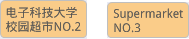
As shown in the right figure, the newline character is set to "-", but it is not displayed when wrapping.
New Line Display (Show the Newline Character) - If a Specified Newline Character is set, the text wraps at that character, and it is displayed at the end of each line.
- If no newline character is set, the text wraps according to the Maximum Text Count per Line.
As shown in the right figure, the newline character is set to "-", and it is displayed at the end of each line when wrapping.
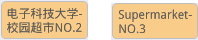
Omit When the text characters exceed the Maximum Text Count per Line, an ellipsis "..." is used instead. 
- Specified Newline Character: When the Overlength Processing Method is New Line (Hide the Newline Character) or New Line (Show the Newline Character), the text will wrap according to the specified character. You can select a newline character from the drop-down menu on the right, or directly type a character as the newline character.
- After the Character: Used to set the position for wrapping when the label text wraps according to the specified newline character. When selected, the text wraps after the specified newline character; when not selected, it wraps before the specified newline character. This check box is selected by default. This check box is unavailable when no newline character is specified.
- Maximum Text Count per Line: When the Overlength Processing Method is New Line (Hide the Newline Character) or New Line (Show the Newline Character), and the Specified Newline Character is empty, this controls the maximum display count of text per line (an English letter, Chinese character, or space counts as one character). When the text exceeds this limit, it will wrap or be omitted according to the settings. Additionally, the Adaptive check box on the right controls whether wrapping strictly adheres to this character count.
- When the Adaptive check box is selected: The wrapping position is automatically adjusted to balance the text length of each line, provided the maximum text count is not exceeded.
- When the Adaptive check box is not selected: The text wraps according to the maximum text count, keeping English words intact.
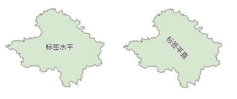
- Label Position: Used to set the label position for polygon objects, supporting Horizontal Label and Straight Label.
- Text Alignment: When the Overlength Processing Method is New Line (Hide the Newline Character) or New Line (Show the Newline Character), sets the text alignment. Supported alignments are: Center, Align Left, Align Right, Distributed Alignment.
- Multiple Lines Align Automatically After Avoiding: When the Overlength Processing Method is New Line (Hide the Newline Character) or New Line (Show the Newline Character), checking this check box will align the text according to the No Overlap rule.
- In-Region Labels: When checked, labels are only displayed within the polygon area.
Repeat Dimension Removal Settings
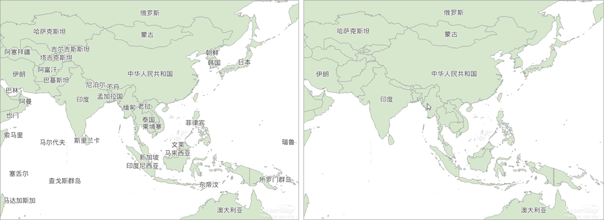
Repeat Dimension Removal Settings are used to set the retention rules and buffer ranges for labels with the same name within the same label layer in the current map's visible range. The system provides different deduplication strategies based on the object type corresponding to the label thematic map.
- All Retained: Keeps all labels with the same name and does not process duplicate labels. This strategy is the default option.
- Keep the First: According to the object drawing order, only the first drawn label with the same name is kept; other duplicate labels are not displayed.
- Buffer Deduplication: Removes duplicate labels based on the buffer distance between duplicate labels in the horizontal and vertical directions, prioritizing the retention of the first drawn label.
- Keep the Largest Object: For labels with the same name, only the label of the longest line object or the largest region object is kept; other duplicate labels are not displayed.
- Maximum Object Retained Within Buffer Distance: Based on Buffer Deduplication, when the buffer ranges of multiple labels with the same name intersect, regardless of drawing order, the label of the longest line object or the largest region object is retained.
When the deduplication strategy is set to Buffer Deduplication or Maximum Object Retained Within Buffer Distance, the buffer distance can be set; when switching to other strategies, these two parameters are unavailable. If a buffer distance has been set previously, switching back to the aforementioned two strategies will retain the last set distance value.
- Buffer Distance (X): Based on the set horizontal buffer distance, duplicate labels within the horizontal buffer range are filtered out and not displayed. Two distance units are provided: 0.1mm and map unit, which can be switched via the drop-down button after the input box.
- Buffer Distance (Y): Based on the set vertical buffer distance, duplicate labels within the vertical buffer range are filtered out and not displayed. Two distance units are provided: 0.1mm and map unit, which can be switched via the drop-down button after the input box.
Note:- Point and multipoint label thematic maps only support three strategies: All Retained, Keep the First, and Buffer Deduplication.
- When generating vector tiles, the Repeat Dimension Removal Settings are invalid;
- If the label expression uses a joined property field from a linked table, the Repeat Dimension Removal Settings are invalid.
- The unit of Buffer Distance in Repeat Dimension Removal Settings is linked with the Offset Settings in the Properties tab and the Offset Y unit in the alignment settings of the Style tab for single symbol label thematic maps. A change in the unit at any location will cause the units in the other two locations to change accordingly.
Label Height Range
- Maximum Text Height: When zooming in, if the height of the text font of the label object exceeds the maximum value set here, the text height within the label object will no longer increase with the map's zoom-in.
- Minimum Text Height: When zooming out, if the height of the text font of the label object exceeds the set minimum value, the text height within the label object will no longer decrease with the map's zoom-out.
Avoid Overlap Settings
- Horizontal: Based on the set buffer range size, text within the horizontal buffer range is filtered out and not displayed. The unit of the Avoid Overlap Settings is consistent with the offset unit in the "Properties" tab. If the offset unit is "0.1mm", then the buffer radius for text avoidance is in 0.1mm; if it is "Consistent with Map Distance Unit", then the unit of the set Avoid Overlap Settings is consistent with the map unit.
- Vertical: Based on the set buffer range size, text within the vertical buffer range is filtered out and not displayed. The unit of the Avoid Overlap Settings is consistent with the offset unit in the "Properties" tab. If the offset unit is "0.1mm", then the Avoid Overlap Settings are in 0.1mm; if it is "Consistent with Map Distance Unit", then the unit of the set Avoid Overlap Settings is consistent with the map unit.
Related Topics