


Feature Description
Resampling is an operation that changes the resolution of a raster dataset. Based on the change in resolution, it can be divided into upsampling and downsampling. Upsampling means the cell side length becomes smaller and the number of cells increases; downsampling means the cell side length becomes larger and the number of cells decreases. During upsampling, when the specific value of the side length is uncertain, you can specify divide the number equally to equally divide the side length of the raster, such as 2 equal divisions, 4 equal divisions, 6 equal divisions, etc. This process is called aliquot resampling.
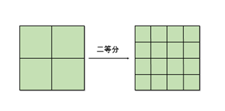
As shown in the figure above, the raster on the right is the result obtained by performing 2 aliquot resampling on the side length of the raster on the left.
Usage Scenarios
For example, a raster with a 30m resolution in a latitude-longitude coordinate system needs to be resampled to 10m, but since the data is in latitude and longitude, the cell size needs to be converted to degrees. In this case, non-divisible situations may occur, and it can only be accurate to a few decimal places. Using aliquot resampling can solve the problem of imprecise manual calculation and entry when converting meters to degrees.
Parameter description
| Parameter Name | Default Value | parameter interpretation | Parameter Type |
|---|---|---|---|
| RDD to Analyze | The RasterRDD that needs to be resampled. | RasterRDD | |
| divide the number equally | 2 | The number of equal divisions for the raster side length. The value must be greater than 1. | Int |
| resampling mode | nearest | Resampling method, including nearest, bilinear, cubic, cubic spline interpolation method, Lanczos method, average. For detailed introduction, refer to the 【Resampling】 tool. | JavaResampleMethod |