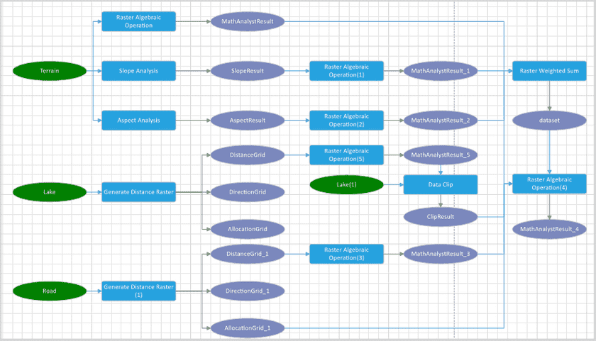
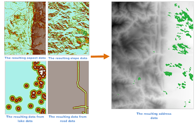
This article introduces the procedure of geoprocessing modeler by an example. We want to select an address for a park. We should consider factors like terrain, altitude, aspect, spaces between surface features, and so on. We can build a model that can extract slope, aspect, and altitude from the given DEM data and get relationships between raster data like lakes, streets, and so on.
Preparing data
Required data:
- Terrain data, lake data, park data, and road data.
Address requirements
- Terrain: slope is lower than 20°.
- Aspect: the better aspect is east south, south, or west south.
- Altitude: the ideal altitude ranges from 1000m to 1800m.
- Distance to lake: smaller than 1 km.
- Distance to street: the address should be 300m far away from the main street.
Procedure of geoprocessing modeler
- Open the datasource: Parklocation.udb
- Click on Geoprocessing Modeler > New to open a new modeler window. We can know that we need to analyze DEM, lake, and road data. Hence, add three data variables (add Data Nodes).
- DEM data variable : add tools Algebraic Operation, Slope Analysis, and Aspect Analysis one by one. Establish relations among tools.
- Altitude: Perform Algebraic Operation on DEM data to assign values of grids whose altitudes are larger than 1000 and smaller than 1800 to 1 and others to 0. The expression is Con(1000<=[terrain]>=1800,1,0).
- Slope Analysis: Perform Slope Analysis on terrain data. After that perform Algebraic Operation on the resulting slope data to assign slopes which are larger than 20 to 0 and others to 1. The expression is Con([Slope]>=20, 1, 0).
- Aspect Analysis: Perform Aspect Analysis on terrain data. After that perform Algebraic Operation on the resulting slope data to select data with good aspect. The expression is Con([AspectResult] <= 0,Con([AspectResult] < 90, Con([AspectResult] <180, Con([AspectResult] <= 270,0, (270[AspectResult])/90), ([AspectResult]90)/90), 0), 1).
- Lake data : To meet one requirement which is the park should be near to a lake, we can select the Generate Distance Raster tool to generate raster grid data from lake data. Set the analysis range to terrain data. And then perform Algebraic Operation on the resulting data to assign distances which are smaller than 1000 to 1 and others to 0. The expression is Con( [LakesDis] >= 1000,1,0).
- Road data : To meet another requirement which is the park should be far away from the main street, we can select the Generate Distance Raster tool to generate raster grid data from road data. And then perform Algebraic Operation on the resulting data to assign distances which are larger than 300 to 1 and others to 0. The expression is Con( [LakesDis] >= 300,1,0).
- Add the Weighted Sum Tool to summarize all factors calculated above.
- Perform Algebraic Operation on the resulting data to assign all values that are larger than 1 to 1 others to 0. Terrain with raster values are larger than 1 applies to build a park.

