Engine, the data pump of SuperMap provides and maintains a complete data model. Besides traditional database engines and file engines, Web engines are also supported by SuperMap SDX+ which allows you to access OGC-based network data service.
1.Database engines
The mainstream of GIS applications is the management of data by using relational databases, including spatial data and business data. Compared to the traditional files, the spatial database technology has obviously advantages in lots of aspects like the management of huge amount of data, integrative storage of graphic and attributes, concurrent access of multiple users (read and write), perfect permission control and security mechanism of data.
Data engines contains: O series based on ODBC data access protocol and Oracle series adopting OCI (API provided by database vendors) development. The O series include SQLPlus engine, PostgreSQL engine, DM engine, KingBase engine, DB2 engine and so on. Oracle series based on the OCI contain OraclePlus engine and Oracle Spatial engine.
Currently, spatial database technology is replacing traditional files and becoming the first choice of more and more GIS application systems for saving spatial data.
Database engines focus on the relational database management system like Oracle, SQL Plus, DB2, Kingbase, etc.. The spatial database is the database of saving, managing spatial data. SuperMap saves spatial data and attribute data into them through SuperMap SDX+ managing and operating on the large-scale relational databases.
SQL Server engine is a purely relational database spatial engine based o the large-scale database SQL Server and it is achieved by using the development tool DB Library provided by Microsoft. Similar to UDB, MDB engines, the engine adopts the data structure customized by SuperMap Objects for building large- scale spatial data applications.
SuperMap Objects introduces the spatial database engine based on Oracle RDBMS to cover the shortage in supports of Oracle Spatial to topology relationship, 3D data, raster data, parameterization objects, and so on. Oracle engine is applicable for building large-scale spatial data applications.

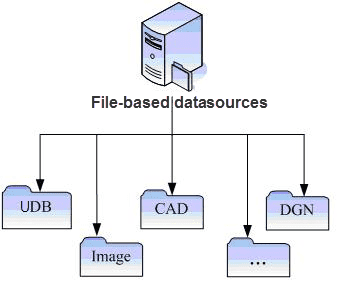
2.File engines
Includes: UDB engine (can be read-write) customized by SuperMap, UDBX engine (can be read-write), image plugin engine (to access image data) and vector file engine (to access external vector files).
- The UDB engine is the only file-based spatial data engine in formats customized by SuperMap Objects. The storage of UDB engine combines traditional files with databases. A project of UDB engine contains two files: one is for saving spatial data with extension is UDB, and another one is an attribute library with extension is UDD. Multiple datasets can be saved into the same UDB project because of the usage of Compound File Binary Format technology adopted by the UDB file. The UDD file adopts the MDB database format of Access different from technologies used by Arc/Info Coverage, MapInfo Table. The UDB project is targeted toward small and medium systems or applications, and aims at improving efficiency thereby fill in weak spots of database engines.
-
The UDBX engine can read, write and manage Spatialite data. What is Spatialite? It is an open-source library for extending the kernel of SQLite and provides a complete and strong spatial database management system. It is cross-platform and lightweight with the support to mature SQL features. Besides, Spatialite can retrieve spatial data efficiently by using the spatial index R-Tree. The UDBX file engine newly added excellently applies the advantages of Spatiallite.
- The use of UDBX file engine does not require the installation and deployment of a database system. When you create a datasource by using UDBX file engine, a UDBX file-based datasource (*.udbx) will be produced, essentially it is a database file. Compared to the UDB file-based datasource, the UDBX datasource is more open, more safe and stable in the operation of data, and it allows multiple uses.
- You are allowed to either create datasets or export data into a UDBX datasource. The supportive formats of datasets in the UDBX datasoure contain: point, line, region, text, CAD, attribute table, 3D point/line/region, EPS compound point/line/region/text, raster, image, mosaic dataset.
- In addition, the UDBX file engine can operate on the spatial data which is exported by a third-party in the Spatiallite database like the display, edit of data. You only need to load the Spatialite database file (*.sqlite) as a file-based datasource into iDesktop.
- The image plugin engine allows SuperMap to display raster data in read-only. The supportive formats contain: BMP, JPEG, RAW, TIFF, SCI, SIT and raster types of ERDAS IMAGINE (BMP and JPEG are common raster data types. RAW and TIFF are remote sensing data types. SCI is a type of pre-cached images customized by SuperMap. SIT is a type of raster data customized by SuperMap). The types of plugin engines includes: BMP, JPEG, RAW, TIFF, SCI, SIT, ERDAS IMAGINE, and all of them are read-only.
- The vector file engine focus on the commonly used vector formats like shp, tab, Acad, etc.. Editing and saving vector files are served.
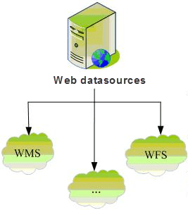
3. Web engine
WFS (Web Feature Service) is the standard of vector map, and WMS (Web Map Service) is the standard of raster map, and WCS (Web Coverage Service) is the standard of image layer.
Web engine can access Web services provided by WFS, WMS, WCS. Web engines process Web servers which meet OGC criterion as SuperMap datasources. With the engine, maps and data in SuperMap can be combined completely with that published by network. Web engines are read-only.