The AvgTemperatureAug field in ProvincesR records the average temperature of each region of China in August 2009. It can be used to generate the average temperature distribution layer for the base map.
Basic Steps:
- Click Provinces_R in the Layer Manger.
- Click Thematic Mapping > Ranges. The system will create a range thematic map with the default style based on the layer Provinces_R. The newly created thematic map will be added to the layer manager and placed at the top of all layers.
- Change settings for the ranges map in the Thematic Map Manager.
- Expression : AVGTEMPERATURE_AUG
- Method : Defined Interval
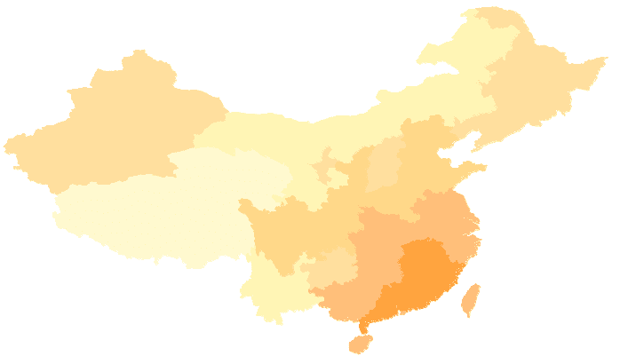
- Range Count : Adjusts the classification with the Merge command on the toolbar. Finally, we have the following 6 subranges: (min, 18), [18, 21), [21, 24), [24, 27), [27, 29), [29, max).
- Set display style for each range : You can keep the default style or change the style. Follow the following steps to change the display style.
(1) Select all subranges and click the filling-style icon on the toolbar to display the Change Style dialog box. Set the line symbol to null to disable the outlines of the regions.
(2) Select a subrange, double click on the color item to open the dialog box Fill Symbol Selector. Specify the fill color for the objects with thematic values within the subrange. For the 6 subranges, the RGBs are (255, 249, 206), (255, 245, 181), (254, 223, 158), (254, 216, 137), (54, 191, 122), (254, 164, 63).
- Set all other layers invisible and you will see the average temperature distribution layer shown as below.
- Select the ranges map in the Layer Manger, right click to display the context menu, and click Save as Thematic Map Template. The Save as Template dialog box shows up. Specify the destination and name for the thematic map template file in XML format.
Note
TemperatureRanges.xml, the thematic map template for the average temperature distribution layer is provided under SuperMap Deskpro .NET\SampleData\China. You can directly apply it to the Provinces_R layer through the Load Thematic Map Template command in the context menu.