Instructions
Creates a grid region dataset which can be used for indexing. A grid can specify pages for an atlas by using map series.
Application scenarios
A grid index region dataset can be used as an index to specify pages for an atlas. In the meanwhile, iDesktop can calculate the names of the adjacent sheets of each grid.
Function entrances
- Open your map. Click the Maps tab > Mapping group > Create Grid Index button.
- Open your map in a layout window. Click the Object Operations tab > Map Series group > Create Grid Index button.
Parameter description
-
Grid index
- Origin X : The default coordinate x of the origin of the output grid index dataset is the coordinate x of the origin of the current map. If you specify several range datasets, the default coordinate x will be determined by the union of the datasets.
- Origin Y : The default coordinate y of the origin of the output grid index dataset is the coordinate y of the origin of the current map. If you specify several range datasets, the default coordinate y will be determined by the union of the datasets
- Width : The width of each grid. You can specify the width. Or the system can calculate the width according to the specified rows.
- Height : The height of each grid. You can specify the height. Or the system can calculate the height according to the specified columns.
- Rows : Specify the number of rows.
- Columns : Specify the number of columns.
- Start Page : The start page number. The default value is 1. The system will specify the number of all pages from the left-bottom polygon.
- Range Dataset : Defines the area of the output grid. The range dataset can be a point, line, or region dataset.
- Generates a mesh region that intersects the range dataset : Only the area that intersects with the input range datasets will be retained in the output grid dataset.
If you don’t check the checkbox, the application will generate the grid dataset according to the specified rows and columns.
Next, perform the operation Calculate Adjacent Fields based on the created grid index.
Instances
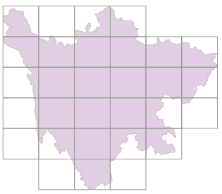
Take the Sichuan province as an example. Set the number of rows and columns to 6. Other parameters are by default. We get the following picture(left) with checking the checkbox Generates a mesh region that intersects the range dataset.
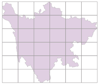
We get the following picture(right) without checking the checkbox Generates a mesh region that intersects the range dataset.

|

|
|---|---|
| Figure 1: the output with checking the checkbox. | Figure 2: the output without checking the checkbox. |