


Spatial Analysis is an analysis technology of Spatial Data based on the location and shape of geographic objects. The powerful capability of Spatial Analysis is the main feature of GIS. 3D Spatial Analysis refers to the spatial analysis of the location and shape of data based on terrain, model, image and other data in 3D Scene.
The presentation of Spatial Analysis in true 3D Scene can express the analysis effect more intuitively. As shown in the figure below, Line-of-sight Analysis and Skyline Analysis are displayed in the scene.
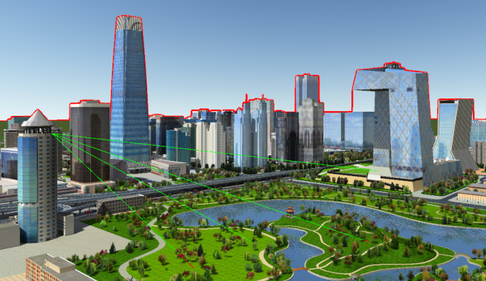 |
| Line-of-sight Analysis and Skyline Analysis in 3D Scene |
3D Spatial Analysis includes Slope and Aspect Analysis, Isoline Analysis, Line-of-sight Analysis, Viewshed Analysis, Dynamic Viewshed Analysis, Skyline Analysis, and more. This chapter will focus on the content and operation of 3D Spatial Analysis and OSGB.
 3D Spatial Analysis
Slope and Aspect Analysis
Analyze the slope and aspect of the Terrain Data within the area based on the specified area.
Isoline AnalysisIsoline Analysis can extract the connecting line of all adjacent points with the same height value in the specified area, and represent the change of the data surface value with the distribution of the line.
Flood AnalysisAccording to the specified maximum and minimum elevation values and submergence velocity, the submergence process of water level rising from the minimum elevation to the maximum elevation in a certain area is dynamically simulated. This function is applied to terrain, DEM and other data.
Line-of-sight AnalysisLine-of-sight Analysis is a common analysis function in 3D GIS, which is used to judge the intervisibility between any two points in 3D Scene.
Viewshed AnalysisViewshed Analysis refers to the analysis of the visibility of a certain observation point within the range based on a certain horizontal angle of view, vertical angle of view and Specify Range radius.
动态Viewshed AnalysisDynamic Viewshed Analysis is to analyze the intervisibility within the Specify Range during driving along the route in 3D Scene according to the specified route based on a certain horizontal perspective, vertical perspective and Specify Range radius.
Openness Analysis3D Openness Analysis is to construct a "view hemisphere" based on a certain View Radius: relative to the specified observation point in the scene, analyze the openness of the area, and simulate the view range of the space around the characteristic observation point.
Sunlight AnalysisAccording to the longitude and latitude range of the specified area, the time length that the area can be illuminated by the sun in a certain period of time is calculated.
Profile AnalysisBased on the specified section line, the change of the surface elevation of the section line and Terrain Data along a line (section), or the contour line of the model building, Underground Pipelines, etc. cut by the section line is output. This feature is available for Terrain Data and Model Data.
Video ProjectionVideo Projection is assigned to the model surface or toposurface for playback. The supported video formats are *.avi.
Skyline AnalysisThe Skyline Analysis function can generate the separation line between the top edge of buildings or other features in the current Scene and the sky according to the observation point.
Cut and Fill AnalysisThe Cut and Fill Analysis function analyzes the fill and haul volume and area within the Specify Range in the scene.
OSGB
The "Generate DSM" function can generate the *.scp data in the current scene into DSM data, that is, generate DSM data according to the OSGB data indexed by the *.scp file.
The Generate DOM "function can generate the *.scp data in the current scene into the DOM data, that is, generate the DOM data according to the OSGB data indexed by the *.scp file. The Result Data is *. Tiff Image Data.
The Generate DOMDSM "function can generate both DOM and DSM Data from the *.scp data in the current scene, that is, generate DOM and DSM Data from the OSGB data indexed by the *.scp file.
。 The function of "Generate 2.5D Vector" is to output the 3D Scene into a 2.5D map to visually display the geographical scene.
"Street Facade Map" function supports the generation of corresponding vector surface data, which brings convenience to the construction planning industry and provides decision support. ".