


Instructions for use
Slope and aspect are two important factors of terrain characteristics, which play an important role in terrain Surface Analysis. The slope is the angle between the tangent plane of a point on the ground surface and the horizontal plane. The larger the slope value is, the steeper the terrain is; the smaller the slope value is, the flatter the terrain is. The direction of slope change is called slope direction, which refers to the downhill direction with the largest rate of change from each pixel to its adjacent pixel direction, and represents the measure of slope direction change at a certain position on the ground surface.
The 3D Slope and Aspect Analysis is used to calculate the slope value of each pixel in the Raster Dataset and the orientation of the slope surface of the pixel. The Analyst Result for slope in degrees ranges from 0 to 90 °; the aspect calculation ranges from 0 to 360 °, starting at 0 ° due north, moving clockwise, and ending at 360 ° back to due north.
Operation steps
- To add Raster Data to the scene as Terrain Data, on the 3D Analysis tab, in the Spatial Analysis group, click
 the button.
 - Click Add and move the mouse to the scene. When a red dot is attached to the top of the mouse, click the mouse on the data surface to determine the starting position of the polygon. After determining the two vertices of the polygon, move the mouse to see the Slope Aspect preview effect within the polygon. Click the left mouse button again to determine the scope of the analysis area. Click the right mouse button to end the drawing and get the Analyst Result.
- After determining the Slope and Aspect Analysis area, you can continue to add Slope and Aspect Analysis ranges or delete Analyst Results in the 3D Spatial Analysis Properties toolbar.
- Parameters such as Display Mode, transparency, and color table can be set for the Slope and Aspect Analysis result, and one or more results can be selected simultaneously in the Analyst Result list for setting:
- Display Mode: It is used to set the Display Mode of Extraction Result. There are three Display Modes that can be set: slope, slope direction and Slope and Aspect. Slope values are represented by different colors, and aspect information is represented by the direction of an arrow.
- Transparency: Used to set the transparency of Texture Filling in the analysis area. The default value is 0.
- Color Table: Set the Fill Color of the analysis area. If the slope of the corresponding area is different, the displayed color will be different. View Slope Aspect information
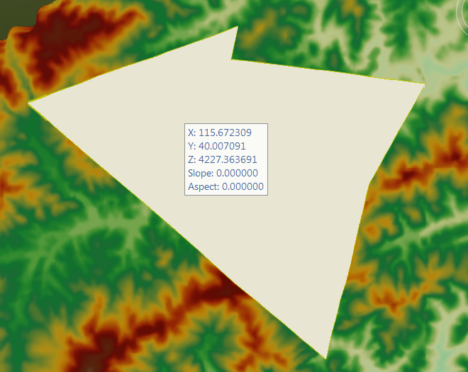
- with the mouse: Check the Slope and Aspect Query control to Move Stop by Mouse to the scene. View the slope and aspect information of the grid terrain or TIN Terrain with normal in the current Analysis Bounds, and click the right mouse button to end. Check "Flow"
- at the bottom left of the Slope and Aspect Analysis panel, and the arrows in the analysis area will have flow effect.
Slope and Aspect Analysis and Search Result
 Button: used to draw a polygonal area that participates in the Slope and Aspect Analysis.
  Button: Use to select a 3D face in the scene as the analysis area.
  Button: used to remove the selected analysis record in the Analyst Result list.
  Button: to import the 3D Region Dataset participating in the analysis.
  Button: for Export analysis range.
  Caution:
 - Supports raster terrains and TIN Terrain with normals. Therefore, the TIN Terrain Cache to be used for Slope and Aspect Analysis should be checked with normal when Generate Cache.
- Slope and Aspect Analysis does not support Plane Scene.