


Flood Analysis
Instructions for use
Flood Analysis refers to the dynamic simulation of the inundation process of the water level rising from the minimum elevation to the maximum elevation in a certain area according to the specified maximum and minimum elevation values and inundation velocity. This function is applied to terrain, DEM and other data.
Application scenario
The application scenarios of this function include:
- According to the rising speed of the flood in a certain area, the inundation process of the flood rising to the specified elevation is simulated, which provides a certain reference for flood control and disaster relief.
- The results of Flood Analysis can provide the basis for the site selection of water conservancy projects or building sites in the river area.
Operation steps
- Add data to the scene for Flood Analysis and click the
 button in the Spatial Analysis group on the 3D Analysis tab to bring up the 3D Spatial Analysis "panel.
 - The 3D Spatial Analysis Properties toolbar provides tools such as adding a Slope and Aspect Analysis range or deleting an Analyst Result.
- Flood Analysis sets the visualization of the results at the 3D Spatial Analysis "panel by setting display and playback parameters. One or more results can be selected at the same time in the Analyst Result list for setting:
- Show Settings:
- Texture Color Table: It is used to set the Texture Filling color of the analysis area. If the elevation value of the corresponding area is different, the displayed color will be different.
- Transparency: It is used to set the transparency of Texture Filling and isoline in the analysis area. The default value is 0.
- Play Settings:
- Current Elevation: used to display and set the elevation value reached by the current water level. The current elevation must be within the range of the minimum elevation and the maximum elevation.
- Minimum Visible Elevation: used to set the minimum elevation of Flood Analysis, which is 100m by default.
- Maximum Visible Elevation: used to set the maximum elevation of Flood Analysis, and the default is 2000m.
- Total time: used to display and set the playback time of the dynamic simulation Flood Analysis results, in seconds.
- Speed: used to display and set the dynamic playback speed from the minimum elevation to the maximum elevation of the currently selected Flood Analysis result. The unit is m/s. Default speed is 100 m/s.
- Loop Valid: When this check box is checked, the Playback operation of the flooding effect will be executed repeatedly when Analyst Result playback is executed until the user stops playing; If this check box is not selected, the flood effect can only be played once when the Playback operation is executed.
- Playback controls, available below the 3D Spatial Analysis panel, allow you to start, pause, or stop playback. The playback effect of Flood Analysis is shown in the following figure:
 Button: used to draw a polygonal area that participates in Flood Analysis.
  Button: Use to select a 3D face in the scene as the analysis area.
  Button: used to remove the selected analysis record in the Analyst Result list.
  Button: to import the 3D Region Dataset participating in the analysis. Fields that set the name, minimum visible elevation, and maximum visible elevation of the Import Dataset.
  Button: for Export analysis range. You can check whether the exported 3D Region Dataset is attached with the following Property Fields: Name, Minimum Visible Elevation, and Maximum Visible Elevation.
 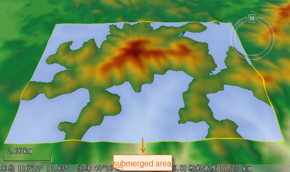 |
| Flood Analysis playback effect |
 Precautions
- This Flood Analysis feature applies to raster terrains.
- The Flood Analysis function for Oblique Photography Model and TIN Terrain data is implemented through the Layer Properties panel corresponding to the data. See Flooding effect for details.