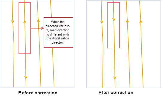
The principle to display the traffic condition with double line is to make specified offset distance for each line to both sides. The offset direction is on the right (positive value) of the line object digitalization direction or on the left (negative value). But sometimes, the two lines has the same digitalization direction, the offset will be wrong. The Traffic Line Correction function can change the same direction to the different direction.
This function will change the source data, so please make a copy for your data first. Note: the following sample data is from NavInfo. If your data is not NavInfo, please use the corresponding fields.
- Click Data>Data Processing>Traffic Line Correction to open the dialog box Traffic Line Correction where you can set the following parameters.
-
Set the road line dataset to be corrected and corresponding fields.
- Start Field: the start node field of the line object.
- End Field: the end node field of the line object.
-
Direction Field: the relation between the road direction and digitalization direction. Set the fields to correspond to BothWay, Forward and Reverse.
- BothWay: it means there is no relation with the digitalization direction, and it is a double-way road, represented by 1;
- Forward: it means the road direction is consistent with the digitalization direction, represented by 2;
- Reverse: it means the road direction is different with the digitalization direction, represented by 3;
- Set the reference point dataset and ID Field to match the start and end fields of line data.
- The Assist Settings part allows you to use different values to express different types of roads, which is convenient for the settings of the road display on a small scale map. SuperMap uses 0, 1, and 2 expressing different types of roads, where 1 is a single line road such as a ramp; 2 is a double-way road such as a highway; 0 is another kind of roads like an auxiliary road on a small scale.
Since the encoding of the same type of roads in NavInfo data is different, we suggest using SQL expression to set the road display type, converting the road-type field values to 0, 1, and 2, and saving them to the field Status. For example, the encoding of the auxiliary roads contains 030a and 060a. The Status values of the corresponding objects are 0.
- Click OK to start.
