


SuperMap ImageX Pro New Features
SuperMap ImageX Pro 11i(2024) R2
Version: 11.3.0, Release Date: 2024.11
Core Capabilities
- Optimized Image Pairing feature,
- Supports extracting pairing rules based on the first manually paired image pair and applying them to remaining pairs.
- Provides image pairing rule editing capability to facilitate pairing of image data from more sensor types.
Production Assistance
- Added Band Operation feature with 29 predefined formulas and custom formulas to meet various industry needs for band operations and parameter inversion of remote sensing data.
- Enhanced Output Result feature, supporting direct selection of local vector files (*.shp) as clipping boundaries to simplify data conversion workflows.
Image Rectification
- Improved Import Control Points feature, allowing adjustment of field-collected control points' weights in image adjustment through X/Y/Z accuracy settings to enhance rectification precision.
- Enhanced Block Adjustment feature, enabling current adjustment results to achieve plane accuracy and edge matching accuracy closer to existing achievements based on prior adjustment files.
- Supports automatic control point collection for RPC images with coarse accuracy (over 6km).
DOM Data Production
- Improved True Color Output feature with maximum/minimum truncation percentage and Gamma parameter support.
Image Quality Inspection
- Enhanced Fine Plane Accuracy feature, supporting partition area settings with automatic partition quantity calculation.
SuperMap ImageX Pro 11i(2024) SP1
Version: 11.2.1, Release Date: 2024.09
Core Capabilities
- Fixed GPA workflow saving mechanism - *.xml workflow files will be auto-saved after execution.
Image Rectification
- Resolved image window shifting issue after filtering connection points by current map extent.
DSM/DEM Production Workflow
- Fixed issue preventing result viewing when generating DSM using GF7 image data.
Image Quality Inspection
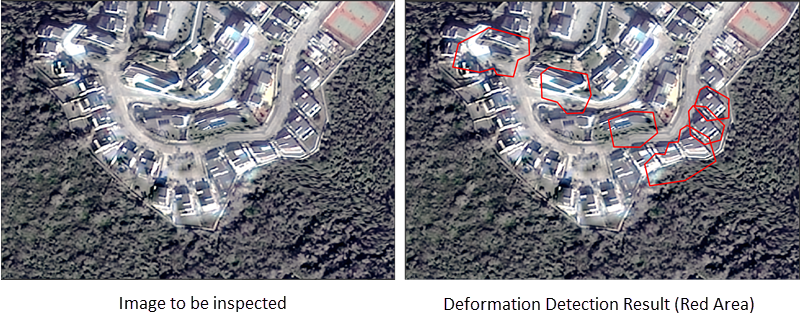
- Improved Deformation Detection by merging adjacent small patches and expanding detection range, making results more prominent for analysis.
SuperMap ImageX Pro 11i(2024)
Version: 11.2.0, Release Date: 2024.06
Core Capabilities
- Added support for new optical satellite sensors: BJ3N3, JL-GP, K3
- Enabled opening *.tif, *.tiff, *.img, *.pix files under Other Datasource node for result viewing
- Added *.pix file support in mosaic datasets for enhanced data management
- Enhanced Map Swipe:
- Supports multispectral, panchromatic and orthorectification layers as swipe layers
- Filters out invisible layers in swipe layer list
- Improved Image Pairing management with add/remove functions for unsuccessful pairs
Production Assistance
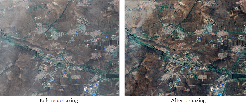
- Added Batch Image Dehazing tool for removing fog/haze:
- Introduced Cloud Replacement tool for cloud-affected areas:
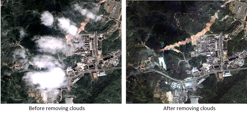
- Improved cloud detection accuracy, reducing false positives on rocks/deserts
- Enhanced cloud detection performance with oversampling achieving >90% thick cloud detection accuracy
Image Rectification
- Upgraded Block Adjustment with multi-image matching and quadratic polynomial RPC correction model
- Improved image matching for original images with large positional deviations to generate high-quality connection/control points
DOM Data Production
- Added Orthophoto-Mosaic automated workflow for direct image mosaicking after orthorectification
- Enhanced Image Color Balancing by ignoring bright cloud areas
- Improved True Color Output with vegetation enhancement
- Enabled standalone execution of Color Balancing, True Color Output, Fusion, and Mosaic using local files
DSM/DEM Production Workflow
- Added DSM/DEM Automated Workflow
- Supported Water Area DEM Correction using vector data:
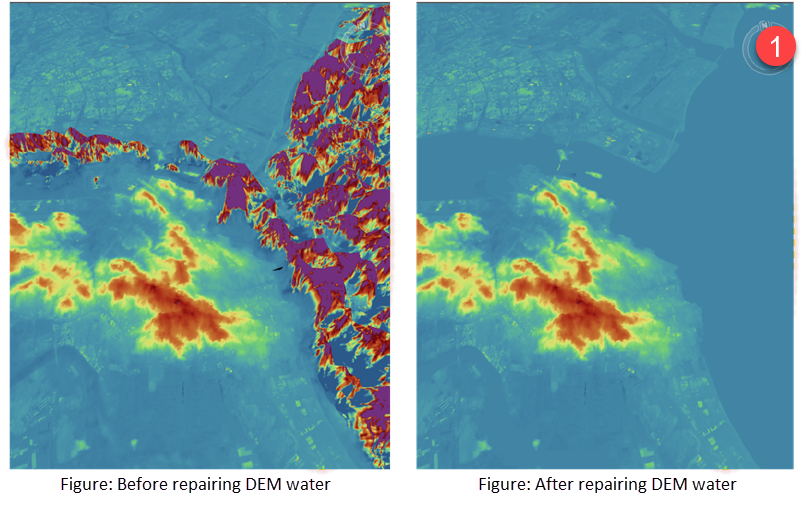
Image Quality Inspection
- Added DOM Planar Accuracy Inspection:
- Detects overall/single-scene/edge-matching accuracy
- Supports auto-generated checkpoints with Checkpoint Management
- Introduced Detailed Planar Accuracy Inspection with grid-based analysis
- Added Deformation Detection for buildings/terrain/roads:
Performance & Accuracy
- Optimized reference image loading performance based on original image range