


Feature Description
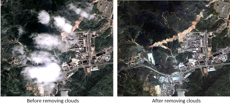
Optical remote sensing imagery is often affected by atmospheric cloud layers during imaging processes. Thin clouds cause ground objects to appear blurry, while thick clouds completely obscure features. Cloud shadows may also project onto the ground surface. To enhance data quality, cloud-affected areas can be replaced with cloud-free imagery from other temporal phases.
The Cloud Removal function addresses these issues by automatically identifying cloud-covered areas and replacing them with cloud-free image data.
When using this function, ensure the original image and reference image share consistent pixel formats, number of bands, and coordinate systems.
Feature Entry
Toolbox->Imagery->Basic tools->Cloud Removal.
Parameter Description
| Parameter | Description | Type |
| Source Image Array | Add cloud-affected imagery requiring processing. | DatasetImage |
| Reference Image | Add cloud-free imagery for replacing cloud-affected areas. | DatasetImage |
| Vector Mask Dataset | Specify the datasource and dataset name containing cloud region vector polygons. | DatasetVector |
| Color Balancing Method | Process color differences at seamlines after cloud replacement:
|
String |
| Buffer Distance | Expansion distance for cloud region vectors. Default: 0.0 (meters). | Double |
| Output Directory | Set result storage path. | String |
| Output Image Settings | Configure output parameters including file type and compression method. Typically used with Create Output Image Settings tool. Can be ignored when used standalone. |
Output
Cloud-removed image data after processing.
Related Topics