ArcGIS Map Document: MXD
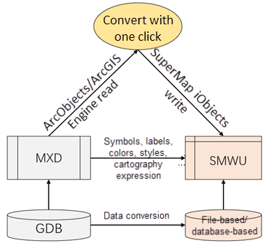
ArcGIS stores a large amount of cartographic expression information through MXD files. MXD is a map file of ArcGIS. It can save configured maps and layouts, including layers, symbols, labels, scales, display ranges, etc., and then uniformly manage configuration information with MXD, and also need to use MXD when you need to publish map services.
SuperMap Workspace: SMWU
The workspace of SuperMap corresponds to the ArcGIS map document MXD, which is the working environment. When performing data operations, you need to create a workspace first. The workspace will save the results of operations in the work environment, including the opened datasources, saved maps, layouts, and three-dimensional scenes. When you open the workspace, you can continue with the results of the last work. SuperMap workspace is stored in *.smwu or *.sxwu format.Please see Workspace for details.
 Map Migration Principle
The migration of map documents includes two parts. One part is the migration of data. For details, please see Data Migration. The other part is the migration of map documents. It mainly transfers information objects such as layers, features, annotations, and symbols in MXD through SuperMap iObjects java completes the creation, writing and setting of corresponding objects, thereby completing the conversion from ArcGIS's MXD to SuperMap's SMWU.

 Support to Migrate Elements
Symbol: Supports converting different types of point, line, and filled symbols from ArcGIS to SuperMap symbols, and the symbol display effects are consistent. It also supports batch conversion of ArcGIS symbol library files to SuperMap library file. For details, please see Symbol Migration.
Label: Supports restoring ArcGIS map annotations through SuperMap's label thematic map. The annotation display style is consistent, and the display priority of annotations is synchronized through overlap and avoidance settings. For detailed instructions on annotation migration, please see LableMigration.
Thematic Map: ArcGIS thematic maps can be converted to the corresponding SuperMap thematic maps. The thematic map display effects are consistent. For detailed instructions on thematic map migration, please see Thematic Map Migration.
Raster Image Map: Supports converting the stretching method of image raster data in ArcGIS maps. The convertible stretching types include: maximum/minimum value stretching, standard deviation stretching, histogram equalization, and percentage truncation stretching. The display effect is consistent. For detailed instructions on raster image stretch matching, please see Raster Image Stretch Match.
Note: The map migration feature requires licensing of ArcGIS-related products.
 Operation Instructions
Functional Entrance
Data Migration > ArcGIS Data Migration->Migrate MXD.
Parameters
- Source Dataset
MXD File: Supports migrating multiple MXD data at the same time. You can select the MXD project file to be converted through the Add File and Add Folder buttons in the toolbar.
- Import Settings
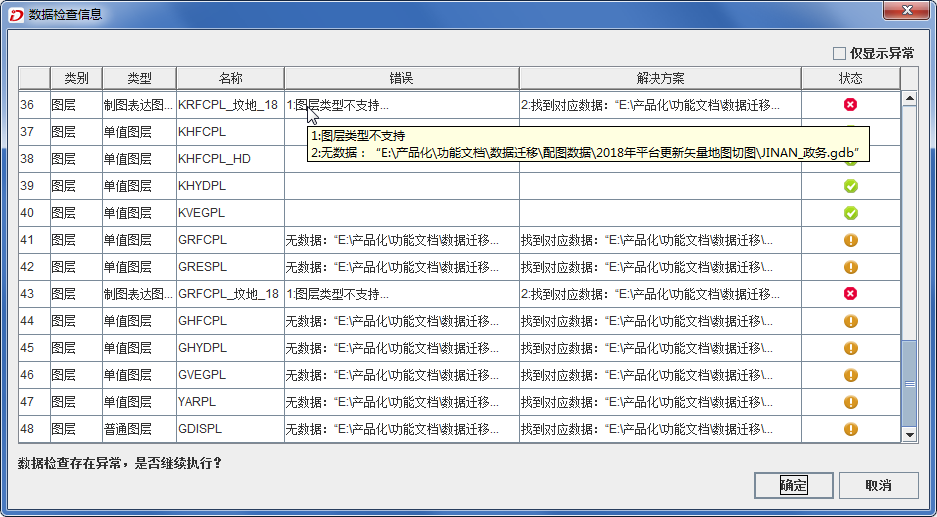
- Check data before executing the operation: Before data migration, it supports checking the migrated data to see whether the data information such as data category and layer type of the source data meets the migration conditions. After the check, a list of result information will be output. You can view the error information in detail and handle the problem according to the provided solutions. Note: If multiple MXD files are added, the data check operation will not be performed.
Errors Solution Status 1. The layer type does not support conversion Do not migrate this layer Do not migrate the layer 2. Data associated with layer not found Search for the data in the MXD directory at the same level. If relevant data exists in the directory at the same level, the data will be migrated to SuperMap iDesktopX. Otherwise, the layer will lack reference data after migration. Migrate Layer 
- Only migrate maps and layouts: If you have migrated the data in MXD, but the maps in the original MXD have been updated or added, you can check the check box to migrate only the maps and layouts in MXD.
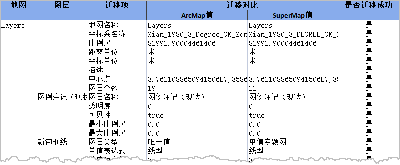
- Generate Migration Report: If you check the check box, a migration report will be generated, including the source and migrated coordinate system, map name, number of datasets, number of objects, field information, etc.
- Verify License: When using the functions of the data migration module, SuperMap iDesktopX will automatically verify whether the required ArcGIS license is present in the computer. If the required license is missing from the computer, it will prompt: "ArcGIS license load failed, please check the license status." For official license of ArcGIS, you can choose according to the license type. For other license, you are recommended to choose Default. The default licensing conditions are as follows:
- If ArcGIS version is 10.4, 10.6, 10.7, or 10.8, the Default option will use ArcServer's license for verification.
- If your computer is using ArcGIS version 10.2, 10.3, or 10.5, the Default option will use Advanced's license for verification.
- Charset: According to the character set of the MXD associated source data file, set the corresponding Charset type.

- Check data before executing the operation: Before data migration, it supports checking the migrated data to see whether the data information such as data category and layer type of the source data meets the migration conditions. After the check, a list of result information will be output. You can view the error information in detail and handle the problem according to the provided solutions. Note: If multiple MXD files are added, the data check operation will not be performed.
- Result Datasource
Storage Type: Supports storing migrated data in SuperMap file datasources or database-based datasources:
- File datasource: By default, it is stored in the file datasource UDBX. During migration, the program will create a new UDBX datasource in the result folder to store the migrated data.
- Database-based datasource: Supports storage in database-based datasources. You can choose database types such as SQLPlus, OraclePlus, MySQL, PostgreSQL, PostGIS, MongoDB, and DMPlus. For detailed instructions on creating a new database-based datasource, please refer to the New Datasource.
- PostGIS: If the MXD to be converted contains data from the PostGIS database, it supports direct reading data without migration.
- Data Sharing: When selecting the PostGIS database, "Data Sharing" is checked by default, that is, data will be directly read. You need to enter the connection information of the current PostGIS database in the pop-up dialog box to read the data directly in the SuperMap workspace. If you uncheck this box and the program will be stored in the newly created PostGIS database by default.
- Result Workspace
Path: Set the output path of the result data and the folder name of the result data.
File Name: Set the file name of the resulting SuperMap workspace.
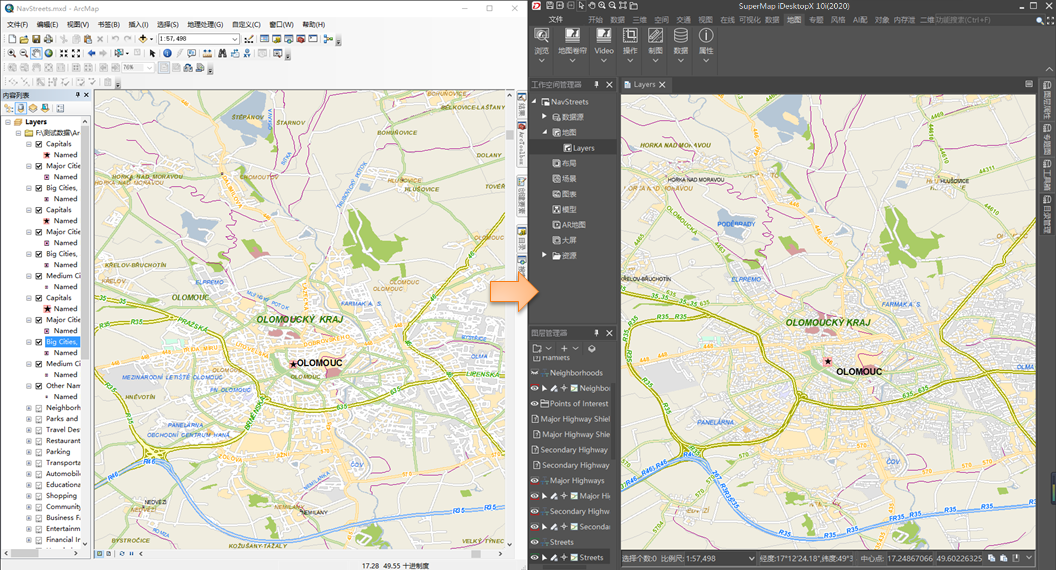
After the migration, the program will automatically open the successfully imported workspace. The following figure is a comparison of the effects before and after the migration.

 Related Contents