Raster image data is one of the important data sources of GIS. Current map production increasingly uses image data to enrich map content and beautify map display effects. Images often require further processing before they can be used, often called image processing. Image processing includes a variety of operations that can be performed on photographs or digital images.
 ArcGIS Image Raster Map
ArcGIS Image Analysis window enables you to analyze and utilize image and raster data in ArcMap through a common set of display functions, procedures, and measurement tools. The Image Analysis window has a number of tools to help improve the appearance of your image by changing the way the histogram is stretched. Sliders are used to adjust the contrast, brightness, and gamma of the image. The interactive histogram stretch button helps us understand the distribution of pixel values and adjust how they are stretched.
 SuperMap Image Raster Map
SuperMap provides practical processing functions for raster data display effects, allowing image data to be better presented in the map window. At the same time, raster data processing can be used to suppress some useless information and highlight useful information, making it easier for people or machines to analyze certain information of interest to improve the use value of image data. Depending on the processing methods, SuperMap provides several types of stretching methods to improve and process the display effect of image data, including: no stretching, standard deviation stretching, maximum/minimum value stretching, histogram equalization, Gaussian stretching, and histogram matching. Please see Display Mode for details.
 Raster Image Replacement Effect
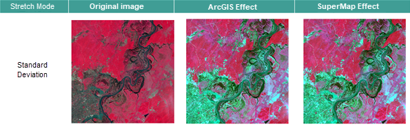
SuperMap iDesktopX can achieve the same effect as after ArcGIS image processing. The following is the migration effect:


 Related Contents