When there are distortions generated during the procedure of turning remote sensing data into images or saving the papery map for a long time, and no spatial position of the scanned papery map, the data registration is required to correct data into the uniform geographical coordinate system or projection system, and to eliminate the distortions. When analyzing multiple datasets at the same time, you can convert their coordinate systems into the same one.
Theory of registration
Data registration is a procedure of correcting and transforming the spatial position of your dataset. With a certain algorithm and control points, a new dataset can be obtained whose spatial position is the same with that of the registration dataset.
If you have the reference layer, you need to specify a registration point in the registration layer, then specify a control point at the corresponding position of reference layer, if you do not have the reference layer, you need to enter coordinates of the control point, then the registration point will be transformed to the right position according to a certain algorithm.
allows you to register one or more datasets meanwhile or you can quickly register your data through a registration configuration file (*.drfu).
The basic steps are:
Step one: creating a New Registration : Specify the datasets you want to correct and the reference dataset.
Step two: selecting the control point : Picking the control point and the reference point that have the same spatial position and features. Or you can import a registration file (*.drfu) including the control point information.
Step three: calculating errors : Select an algorithm to calculate the registration errors. Residual X, residual Y, root mean square error and root mean square total error of control points will be calculated out to verify the selection accuracy of control points.
Step four: executing registration : When the registration error falls into the range of accuracy, you can perform the registration and you are allowed to export registration information.
Application:
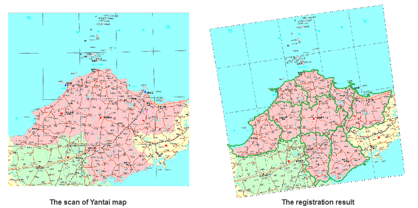
The left picture below is a scan of Yantai map. Register the scanned map to make its coordinate system is the same with that of the vector region datasets of Yantai, then the result map can overlay with the vector dataset like the right picture shows.
The base map in the result is the scan of the Yantai map, and the green polygons are the reference data (a region dataset on Yantai area)
