


Raster Reclassifying
Feature Description
Reclassifies cell values of source raster data and assigns new classification values, effectively replacing original pixel values with new values. Raster reclassifying is only applicable to raster datasets (GRID), not image datasets (IMAGE).
Raster reclassifying is primarily used in four scenarios:
- Replace old cell values with new values. For example, assigning new pixel values to reclaimed wasteland converted to farmland during land type updates.
- Simplify data by regrouping large numbers of cell values into categories with identical values. For instance, classifying dryland, irrigated land, and cultivated land as agricultural land.
- Standardize classification across multiple raster datasets. For example, when assessing building site suitability based on soil and slope data, both input raster datasets can be reclassified using a 1-10 scale for subsequent analysis.
- Set unwanted cells as NoData or assign new values to previously NoData cells for further processing.
Feature Entry
- Data Tab->Data Processing->Raster->Reclassify.
- Toolbox->Data Processing->Raster->Reclassify.
Parameter Description
Reclassification list tool description:
- Range Settings: Select reclassification method.
- Interval: Define ranges using specified intervals. The system segments values starting from the raster minimum, incrementing by the interval until reaching maximum value. For example, with minimum 200 and interval 200: ranges 200-400, 400-600, etc.
- Ranges: Determine number of classes (default 10). The system automatically calculates equidistant ranges between min/max values. Example: min=200, max=1000 with 4 classes creates ranges 200-400, 400-600, 600-800, 800-1000.
- When enabling Ranges, choose Equal Interval or Natural Interval classification in Segmentation Method.
- Default Class: Use system default classification.
- Union Multi-line: Merge consecutive selected records into single range (min from original records as new from, max as new to). Disabled when selecting non-consecutive records.
- Split Line: Divide selected record into two equal sub-ranges. Disabled when multiple records are selected.
- Import Raster Reclassify Config File: Import *.xml configuration file to apply predefined reclassification parameters.
- Export Raster Reclassify Config File: Save current classification settings and parameters as *.xml file for reuse.
- Reverse Ordering of Target: Invert assignment order of new cell values.
- Reclassification Type: Choose Reclassify Range or Reclassify Unique Value.
- Reclassification List: Customize classification ranges with three components per entry:
- From: Minimum value of classification range.
- To: Maximum value of classification range.
- Target Value: New value assigned to all cells within the range.
- Pixel Format: Set pixel format for output dataset. Options: 8-bit (unsigned), 16-bit (unsigned), 32-bit (integer), 64-bit (long), single, double. Default: 16-bit. See Raster Dataset Pixel Format.
- Range Interval: Define interval closure status:
- Left Close Right Open: Include left boundary, exclude right boundary.
- Left Open Right Close: Exclude left boundary, include right boundary.
- Empty Value: Maintain NoData status or assign new value to source NoData cells.
- Unclassified Cells: Assign uniform value to cells not covered in reclassification list.
- Result Data: Select output datasource and name. Defaults to same as source datasource.
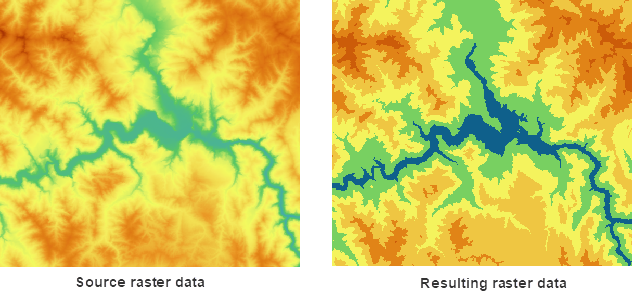
Figure: Comparison of Raster Reclassification Results
Related Topics