


Raster Mosaic
Feature Description
Combines two or more raster datasets referenced by GCS into a single raster dataset.
The following examples demonstrate two different scenarios of raster dataset mosaicking.
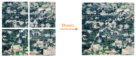 |
| Figure 1 |
Feature Entry
- Data Options tab->Data Processing->Raster->Raster Mosaic.
- Toolbox->Data Processing->Raster->Algebraic Operations.
Parameter Description
- No Value: Specifies the no-data value in raster datasets. Positions filled with this value are considered invalid, defaulting to -9999. Users may input a custom no-data value.
- No-Value Tolerance: Tolerance range for specified no-data values, independent of original no-data values in raster.
- Resolution: Cell size of the resulting dataset. Default value 0 indicates using the minimum resolution from all input datasets.
- Overlap Value Handling: Method for handling overlapping areas during mosaicking. Default uses "First Dataset Value". Other options: "Last Dataset Value", "Max of All Datasets", "Min of All Datasets", "Mean of All Datasets".
- Result Pixel Format: Pixel format type for output raster data.
 Notes:
- Single-precision and double-precision formats are unsupported for image dataset mosaicking.
- Ensure input rasters share the same coordinate system and equal number of bands.
Related Topics