


Chart is a graphical representation tool for displaying maritime areas or water bodies and their surrounding geographic features, widely used in marine navigation. According to different scales, charts provide critical data such as water depth, navigation channels, seabed topography, obstacles, navigation aids, and tidal information to ensure safe vessel navigation. As essential tools for maritime navigation, many countries require vessels to carry charts for safety compliance.
Chart Classification
Charts are categorized into paper charts and electronic charts:
- Paper charts are traditionally printed.
- Electronic charts are computer-generated, offering greater update flexibility and interactivity. They provide additional safety information not covered by paper charts, such as route guides.
This document focuses on Electronic Navigational Charts (ENCs), produced and published by national hydrographic offices, specifically designed for Electronic Chart Display and Information Systems (ECDIS) to ensure accurate navigation information for vessels.
Data Specifications
Due to the specialized, global, and practical nature of electronic charts, they adhere to stricter specifications than land maps in data production, transmission, display, and modification. Over the years, organizations like the International Hydrographic Organization (IHO) and International Maritime Organization (IMO) have promoted standardization through these key specifications:
- S-57: Digital Hydrographic Data Transfer Standard for vector-based electronic chart data exchange, legally binding.
- S-52: Specifications for Chart Content and Display of ECDIS, defining content, display, colors, and symbols.
- S-58: Electronic Chart Validation Standard, ensuring spatial and attribute validity to enhance production quality.
- S-100: Universal Hydrographic Data Model, supporting multiple marine data sources, products, and users as a modern standard for marine geospatial data.
Technical specifications for inland electronic charts:
- IENC: Inland Electronic Navigational Chart specifications ensure unified production of IENCs and support their effective application in Inland ECDIS. Developed by IHO and refined by the Inland ENC Harmonization Group (IEHG).
- CJ-57(JTS 195-3-2019): Technical Specifications for Inland Electronic Navigational Charts, a mandatory industry standard issued by China's Ministry of Transport to regulate production/application of inland electronic charts and improve waterway informatization.
Product Capabilities
SuperMap iMaritimeEditor, developed based on SuperMap iDesktopX, is a desktop software for displaying and editing chart data.Chart module provides capabilities for data conversion, display, query, editing, validation (per S-57/S-52/S-58/CJ-57/IENC standards), data dictionary management, and environment configuration to build ECDIS compliant with international standards. Supports display and attribute queries for five S-100 series products: S-101, S-102, S-104, S-127, and S-131.
SuperMap iDesktopX offers a new platform for vessel monitoring using charts, contributing to China's electronic chart standardization. It overcomes traditional charts' "water-focused, land-neglected" limitations by integrating chart data with land data, enabling unified storage, display, query, editing, and publishing of marine/terrestrial data. This supports maritime transportation, integrated emergency response, and resource development.
SuperMap iDesktopX supports multiple international standards and data management functions:
- Data management & editing: Supports S-57/CJ-57/IENC-compliant chart management, feature editing, and sounding management.
- Data display: S-52-based electronic chart display and interaction.
- Data validation: Checks chart data per S-58 to ensure international compliance.
- Multi-standard support: Integrates S-101/S-102/S-104/S-127/S-131 data for unified display/query.
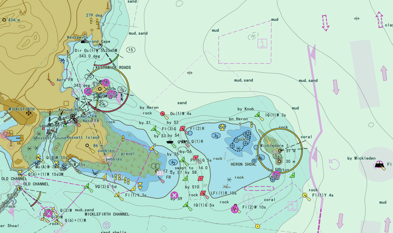 |
| Figure: Electronic Navigational Chart (ENC) |
This chapter covers:
- Chart Basics:
- Chart terminology: Product specifications, data structures, and electronic chart display.
- Chart data storage: Feature/spatial object relationships, chain-node model, and dataset grouping.
- Fundamental operations: Importing S-57/CJ-57/IENC data and viewing object attributes.
- Chart Groups: Dataset group types, creation/deletion, and conversion.
- Chart Browsing: S-52-compliant display settings, depth settings, and filter settings.
- Chart data production: Workflows for S-57/CJ-57/IENC data import, feature selection, attribute review.
- Chart standard extension: Feature definition queries and standard extensions.
- S-100: Concepts and integration of S-101/S-102/S-104/S-127/S-131 data.