


SuperMap iDesktopX supports viewing electronic chart data compliant with S-57, CJ-57, and IENC standards through direct opening or import, and also supports viewing updated nautical chart (*.001) data via import.
Direct Opening
When directly opening *.000 files compliant with S-57, CJ-57, and IENC standards, the files are in read-only mode and cannot be edited. There are two specific operation methods:
- Method 1: Drag and drop *.000 files directly into the workspace. In the Open: [Chart 000 File] dialog, set the Standard Type under Parameters to match the data standard. Note: The default Standard Type is S-57. If it doesn't match the data file, the data cannot be opened properly. The setting result will display before the filename for verification.
- Method 2: Right-click the Datasources node in Workspace Manager -> Open File Datasource, select and open *.000 files. Similarly, configure Parameters in the Open: [Chart 000 File] dialog.
Import Nautical Chart Data
Supports importing *.000 files compliant with S-57, CJ-57, and IENC standards into file databases, database datasources (PostGIS or DMPlus), or EMS datasources. Note: The target datasource for importing nautical chart data cannot be read-only.
Importing nautical chart data enables editing, processing, and production operations. Taking S-57 as an example, the procedure is as follows:
- Right-click an opened editable datasource and select Import Nautical Chart Data -> S-57.
- In the Import Nautical Chart Data dialog, select one or multiple S-57 *.000 files.
- After selecting files, the Import S-57 dialog displays selected files in a list with the following parameters:
- Source File: Shows the name of imported chart data (non-editable).
- Source Data: Shows the path of imported chart data (non-editable).
- Target Datasource: Shows the target datasource name. Use the dropdown to select other datasources in the current workspace.
- Project: Sets whether to convert the projection type to Mercator.
- Chart data is typically produced and distributed using WGS84 geographic coordinate system (EPSG:4326). Consider specific requirements for projected coordinates during import.
- Mercator projection is widely used in nautical charts worldwide due to its advantage in safe marine navigation. It features rhumb lines (lines of constant bearing) as straight lines, ideal for maritime navigation.
- Check this box to convert the projection to Mercator. After projection, map units become meters for easier distance measurement.
- Encode Type: Specifies whether to save chart data using compression to save disk space. Default is non-encoded (no compression). Options include single-byte, double-byte, triple-byte, and quadruple-byte encoding. For details, see Dataset Compression Encode Type.
- Editable: Checked by default, allowing data editing after import. If unchecked, data imports as a non-editable chart group. To modify later, convert non-editable chart group to editable.
- When importing multiple *.000 files, use the Select All, Select Reverse, and Bulk Settings buttons on the dialog toolbar to quickly select files and set target datasource, encode type, and projection type in batch.
- After configuring parameters, click Import to complete S-57 data import. Data will display as a chart group under the corresponding datasource in Workspace Manager.
View Updated Nautical Chart (*.001) Data
Per international standards, initial chart data files use *.000 extensions. Subsequent updates use *.001 to *.999 extensions, incrementing by 1 with each update.
- Requirements for viewing updated files:
- To view *.001 to *.999 files, place update files in the same directory as the corresponding *.000 file with matching filenames.
- When importing nautical chart data, the application automatically recognizes and merges update files into the *.000 file. Thus, selecting the *.000 file during import includes all *.001 to *.999 updates.
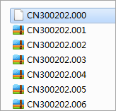
- Example:
- A user has chart data containing CN300202.000 (to import) with updates 001 to 006 in the folder as shown below.
- After import, the application automatically merges all 6 files into one complete dataset.
 Caution:
If initial import includes only 001, 002, 003 files, adding 004, 005, 006 later will automatically merge all 6 files into the 000 file upon re-import.
Related Topics