


Instructions for use
Geofencing analysis can set the boundary of a specified area in the video as a fence, triggering corresponding messages, notifications, or warnings when a target enters or leaves this area. Video geofencing technology is widely used in fields such as traffic monitoring, security, and public safety, for example, detecting vehicles entering bicycle lanes or bus lanes for violations, and restricting shared bicycle parking.
After video registration to geospatial coordinates, geofencing vector data can be overlaid with video data. Based on object detection, the position of targets is tracked to analyze whether the target intersects with the geofencing boundary, thereby determining if the target has committed a violation. In the transportation field, the monitoring target for geofencing can be set to motor vehicles. When a motor vehicle illegally enters the geofencing area, a warning message can be promptly displayed in the video, and violation photos can be captured, enhancing the efficiency, real-time capability, and accuracy of monitoring motor vehicle violations.
Feature Access
- Video Analysis tab->Transport Analysis group->Geo-fencing Analysis button.
- Video Analysis tab->Transport Analysis group->Geo-fencing Analysis drop-down button->Geo-fencing Analysis.
Operation Steps
- Click the Video Analysis tab->Transport Analysis group->Geo-fencing Analysis drop-down button->Fence Display Style button. In the pop-up Fence Display Style dialog, you can set the text style for violation show labels, including font and font size.
- Directly click the Geo-fencing Analysis button, or select the first option in the Geo-fencing Analysis drop-down button, which is Geo-fencing Analysis, to pop up the Geo-fencing Analysis dialog. The parameters in the dialog are described as follows:
- Detection Area: Sets the fence area for detection. When a target is within the fence, it indicates that the target has committed a violation. Users need to select the fence area dataset and the data source where it is located.
- Analysis Rule:
- Analysis Rule: After selecting the analysis rule row, click the drop-down button in the analysis rule column cell to select specific rules. The program provides three rules: occupy bus lane, occupy non-motorized vehicle lane, occupy emergency lane.
- Analyze Region: Allows users to set the polygon information corresponding to this rule. Click the analyze region cell to display a … button. Click this button to enter the SQL Expression dialog, where you can filter polygon information using SQL Expression. For example, the attributes of bus lanes, emergency lanes, and bicycle lanes are different and can be filtered via SQL Expression.
- Analysis Standard: Sets whether the system issues violation information when the detection target is contained within or not within the analysis polygon. Provides two settings: contained and not contained.
- Violation Photo Storage: Check this box to save photos of violation vehicles (*.png) as evidence when detected.
- Result Folder: Select the folder path for storing photos.
- Save Interval: Sets the interval time in seconds for saving violation photos when target tracking is not enabled or cannot track the target after enabling, but geofencing analysis has results. When the interval is 0, photos are saved frame by frame. To improve performance, it is recommended to set an appropriate interval.
- Intersection Area Ratio: The ratio of the intersection area between the vehicle detection box and the fence area to the area of the vehicle detection box, used to determine if the detected vehicle is contained within the fence area. If greater than the specified value, the vehicle is judged to be in this area; otherwise, it is not.
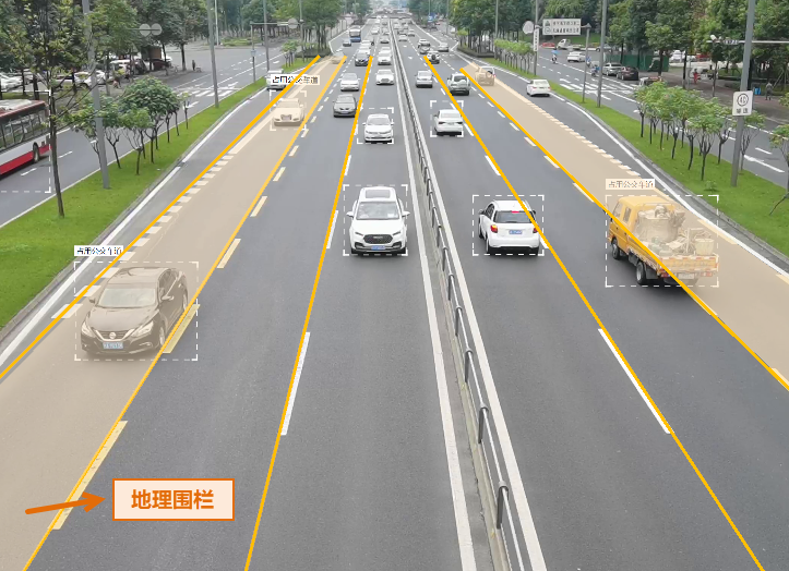
- After setting the above parameters, click play video. Targets entering the geofencing area will display the text "Violation" above them, and their violation photos will be stored to the specified path. In the figure below, the analysis rule is set to occupy bus lane. When a vehicle enters the bus lane, "Occupy bus lane" is displayed above the vehicle.
Related Topics