


S-101stands for IHO Electronic Navigational Chart (ENC) Product Specification for IHO Electronic Chart. Also known as S-101 Electronic Chart (S-101 ENC), is the latest product specification for Electronic Chart (ENC).
- Relationship with S-100 standard: As the most basic specification in the S-100 product specification system, S-101 provides the basic base map of Electronic Chart. Other S-100 series interoperable products may be superimposed on the S-101 base data , Uch as S-102 water depth surface and S-104 navigation water level .
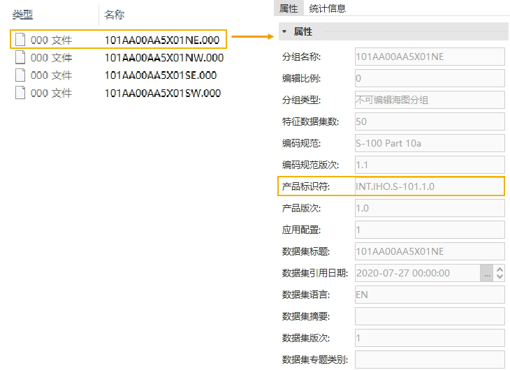
- Data content and format: S-101 specifies the compilation content, structure, data coding and metadata of Electronic Chart data, and the data storage format is *.000 file. Corresponding to Chart Group in SuperMap iMaritimeEditor, Chart Group contains chart feature Dataset. As shown in the figure below, S-101-compliant *.000 data attributes typically include information such as name, characteristic Dataset number, encoding specification, and Dataset reference date and product identifier.
 |
 |
| 000 documents and Attributes according to S-101 specification | S-101 Electronic Chart |
The S-100 series is often considered an update to the S-57 series standard (see S-100 Overview ). Comparing the two series of specifications, S-101, which is also an Electronic Chart data specification and stored in *.000 format, is a replacement for S-57 (Digital Hydrographic Data Transfer Standard).
SuperMap iMaritimeEditor supports opening, displaying, and attribute querying of S-101 data. By default, the visibility of the entire chart frame is controlled according to the maximum and minimum Display Scale of the DataCoverage element in the S-101 Chart Data grouping. In this section, you will learn the following:
- Open S-101 Data : describes how to import a *.000 file that follows the S-101 Electronic Chart data standard.
- S-101 Data display: describes how to display Chart Data by setting the Color mode and Water depth mode . It also supports the setting of Chart Display Type .
- View S-101 Data Grouping Properties : describes how to query Attributes and Statistic Infomation of S-101 data grouping.
- View S-101 Feature Object Properties : describes how to view the Attributes, Reference Objects, and Nodes of S-101 feature objects.