


Feature Description
The system supports various layer types including point layers, line layers, region layers, text layers, grid/image layers, and thematic map layers. All layers can be overlaid and displayed in the Layer Manager. Through the Layer Control drop-down button in Layer Manager, users can utilize the Layer Control and Layer Nodes Can Be Dragged features to manage individual or multiple layers collectively.
- Layer Control: Manages the status and parameters of single or multiple layers in the map.
- Layer Nodes Can Be Dragged: Determines whether layer nodes are draggable. This feature helps lock the layer order in Layer Manager to prevent accidental adjustments when handling numerous layers.
This document primarily explains the parameters in the Layer Control dialog.
Feature Entry
Layer Manager -> Layer Control button.
Parameter Description
Toolbar
The top-left corner of the Layer Control dialog provides tools including Add Data, New, Delete, Select All, Invert Selection, Bring to Front, Up, Down, and Bring to Back for adding layers, deleting layers, or adjusting layer display order.
- Add Data: Add data to the layer list to display more layers.
- New: Add new layer groups to the layer list, which are managed in the same way as in Layer Manager. The New drop-down also includes a layer snapshot creation feature. For details, see Using Snapshot Layers.
- Bring to Front/Up/Down/Bring to Back: After selecting layers in the Layer List, use these buttons to adjust display order. Alternatively, enable the Layer Nodes Can Be Dragged feature in Layer Manager's Layer Control drop-down and adjust layer order via drag-and-drop.
Layer display order directly affects map visualization. General rules for layer ordering are:
- Based on object map bounds: From top to bottom as small -> medium -> large.
- By layer type: From top to bottom as text/point -> line/region.
 Note:
Note:These rules are general recommendations. Different mapping requirements may necessitate alternative sorting methods.
The following two maps demonstrate display effects before and after moving a road line layer to the bottom. The comparison clearly shows the importance of layer stacking order.
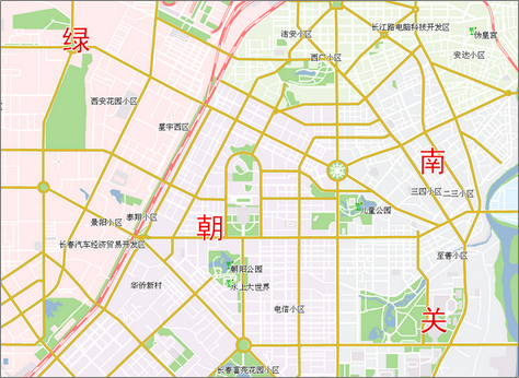
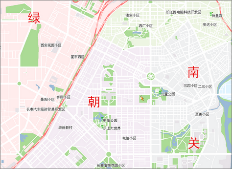
Map Display Before Layer Adjustment Map Display After Layer Adjustment
Layer List
The bottom-left section of the Layer Control dialog displays a layer list showing all layers in the current map, maintaining the same display order as in Layer Manager.
Parameters
The right panel of the Layer Control dialog displays parameters of selected layers, allowing users to modify settings and control display effects.
- Display Control: For vector, raster, or image layers, the Display Control group provides common parameters. See Setting Layer Common Properties.
- Vector Parameters: Displays vector dataset parameters when selecting vector layers, including Show Full Line, Intersection, Scale With Map, Minimum Object Size, and Display Filter. See Setting Vector Layer Properties.
- Image Parameters: Displays image dataset parameters when selecting image layers, including Brightness, Contrast, Transparent Color, Interpolation Method, Display Method, and Stretching. See Setting Image Layer Properties.
- Grid Parameters: Displays raster dataset parameters when selecting raster layers, including Brightness, Contrast, Color Table, Specified Raster Value Style, and Raster Functions. See Setting Raster Layer Properties.
Note:When loading a network dataset into the map, it contains both network node layers and network line layers. Network node layer controls resemble standard point layers, while network line layer controls function similarly to standard line layers.
Related Topics