


Display Control
The Display Control group organizes common parameters for layer properties. For details, refer to Setting Layer Common Properties.
Show Full Line
Show Full Line ensures complete display of line symbol patterns, optimizing line symbol display effects.
When a line object's length is shorter than the symbol cycle length or not an integer multiple of it, the remaining part cannot display fully. Enabling Show Full Line recalculates symbol length through division to achieve approximate alignment with object length.
Example: When using line marker style  on line objects shorter than one symbol cycle:
 |
 |
| Without Show Full Line | With Show Full Line |
This feature particularly improves display effects for short lines or layers with complex polylines, enhancing map aesthetics.
Intersection
Line layers often contain intersecting features (e.g., rivers, roads). Unprocessed intersections may appear unprofessional and fail to represent real-world connectivity.
- Applies to standard line layers and network data layers, excluding CAD layers and route data.
- Only effective for double-line styles
 , not single-line styles
  .
.
Check Intersection to enable crossing optimization:
 |
 |
| Before Intersection | After Intersection |
Scale With Map
Controls whether map symbols scale during zoom operations. Applies to point symbols, line symbols, and fill patterns.
Enable Scale With Map to maintain proportional symbol sizing during zoom.
Anti-Alias
Raster displays may show jagged edges (aliasing) on diagonal lines/polygons due to discrete pixel sampling. Anti-aliasing reduces this effect through advanced rendering techniques.
Check Anti-Alias to enable, requiring simultaneous map anti-aliasing activation.
Show Overlap
Controls overlapping object display. Requires Show Overlap at map level.
Show Full Label
Controls complete label display. Requires Show Full Label activation at map level, effective for labels and point symbols.
Scale Reference
Symbol scaling depends on scale reference and current map scale. Symbols enlarge when map scale exceeds reference scale, and shrink when below.
Example: With 1:500,000 reference scale and 30pt symbols, at 1:100,000 scale (5x zoom), symbols display at 150pt.
After enabling Scale With Map, use Set to Current Scale to assign current scale as reference. Clear disables scaling.
 Notes:
Disabling scaling when reference scale differs from current scale may alter symbol sizes proportionally.
Minimum Object Size
Sets minimum display size for layer objects. Objects become invisible when maximum bounds dimension falls below threshold during zoom.
Rarefy Display
Optimizes performance for dense geometries by merging/removing nodes within tolerance thresholds.
Example: Tolerance=1px, Threshold=100 nodes. Objects exceeding 100 nodes within 1px range undergo simplification.
Excessive tolerance may disconnect adjacent features due to display-level processing without topological consideration.
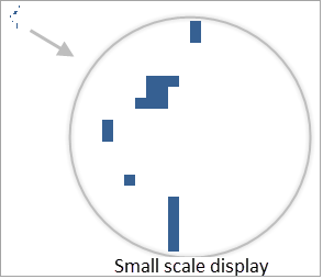
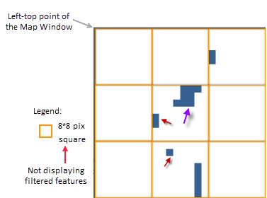
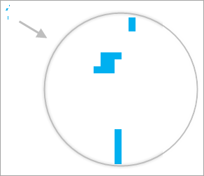
Filter Small Overlapping Objects
Filters objects where both dimensions < minimum size. Within specified tolerance, displays only one representative object.
Example: Tolerance=8px, Minimum Size=8px. Multiple sub-8px objects within 8px grid display only the first-drawn object.
 |
 |
 |
| Disabled | Filter Process | Enabled |
Compared with Minimum Size filtering, this maintains at least one object per area unit.
Display Filter
Filters layer display using SQL conditions. Edit directly or via ... button.
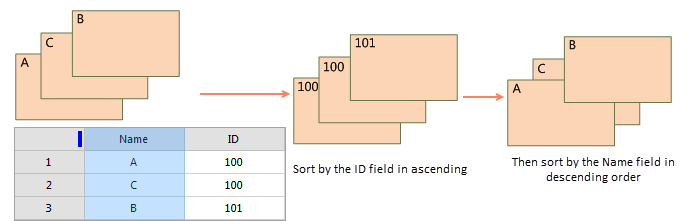
Display Order
Controls drawing sequence through numeric fields. Multi-field sorting supported.
Setup steps:
- Click ... to open Display Order Field Settings
- Click New to add sorting criteria
- Select fields and sort direction (Ascending/Descending)
- Adjust priority using Bring to Front, Bring to Back, Up, Down
Default drawing order uses SmID ascending without configuration.
Supported for single vector layers or thematic layers.
| Field | Order | Example |
| SmID | Ascending | 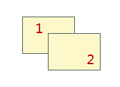 |
| SmID | Descending | 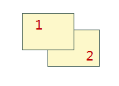 |
Multi-field sorting example:
 |
Notes:- Display Order disables intersection effects
- Separate multiple fields with commas, e.g., "field1 asc,field2 desc"
- Settings save to map/workspace for reuse
Join Attribute Table
Links external attribute tables via selected fields for enhanced filtering capabilities.
Set WMS Service Hidden Field
Controls field visibility in published Web Map Services. Hidden fields remain available elsewhere.
Related Topics
Setting Layer Common Properties
Setting Raster Layer Properties
Setting Image Layer Properties