


The production of DOM from original images typically includes data preparation, radiometric correction, geometric correction, orthorectification, image registration, image fusion, image color balancing, image mosaic, image cropping, and final output. Each step requires manual intervention with complex operations and low efficiency.
SuperMap ImageX Pro integrates these steps into a highly automated DOM Production Process. This process simplifies the complex operations in traditional workflows, significantly improves production efficiency, and lowers the barrier to use. The reusable nature of this workflow ensures consistent processing results across different image batches.
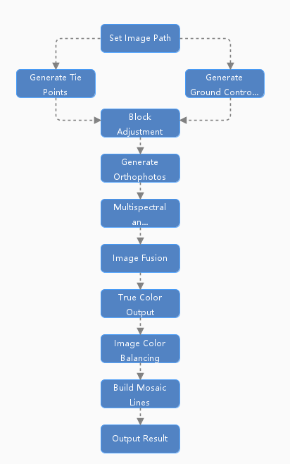
This workflow is enabled by default in the initialization interface, aiming to rapidly and efficiently process original remote sensing imagery into DOM data. The workflow steps are described as follows:
- Set Image Path: Specify the processing paths for raw imagery, reference imagery, and result data. Supports filtering and pairing of raw panchromatic and multispectral images.
- Generate Tie Points: Automatically generates tie points in overlapping image areas for mosaicking and block adjustment of multiple satellite images, ensuring geometric consistency among them.
- Generate Ground Control Points: Generates Ground Control Points based on image feature points for high-precision geometric correction and geolocation, ensuring the geographic positional accuracy of the imagery.
- Block Adjustment: Calculates the orientation parameters of the satellite images through adjustment computation based on the tie points and ground control points.
- Generate Orthophotos: Orthorectifies the imagery to remove geometric distortions caused by terrain relief and sensor attitude, producing a panchromatic orthophoto.
- Multispectral and Panchromatic Registration: Registers the multispectral imagery to the corrected panchromatic image, ensuring precise spatial alignment between the panchromatic and multispectral data.
- Image Fusion: Performs pan-sharpening (or other fusion techniques) to combine the panchromatic and multispectral images, enhancing image quality by integrating their respective spatial and spectral details.
- True Color Output: Applies image stretching and enhancement techniques to improve the visual display effect, making the colors closer to the actual ground object colors.
- Image Color Balancing: Adjusts the color, brightness, and contrast of the imagery to improve overall quality and visual consistency across scenes.
- Build Mosaic Lines: Automatically generates seamlines based on specified methods. During mosaicking, overlapping areas are cut along these seamlines to ensure seamless and natural-looking results.
- Output Result: Exports the processed image results. Supports outputting the DOM data as a full scene, standard map sheets, or clipped according to a vector polygon.
 |
| Figure: DOM Production Workflow |