


Instructions for Use
Due to factors such as weather conditions, human factors, and sensor characteristics, acquired remote sensing imagery often suffers from inconsistencies in color and brightness. These issues not only lead to errors during image mosaicking but also cause noticeable color differences on both sides of the seams in the mosaicked image, significantly affecting the visual quality and usability of the entire image.
Image color balancing adjusts the color, brightness, and contrast of the imagery, effectively reducing tonal differences between images. It achieves uniform tones, moderate contrast, and distinct layers while ensuring that ground object colors remain undistorted, significantly improving the overall quality and visual consistency of the imagery.
SuperMap ImageX Pro 11i(2023) version starts to support this feature.
 |
 |
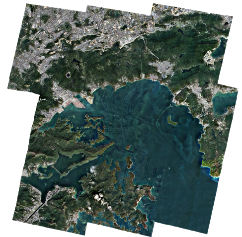 |
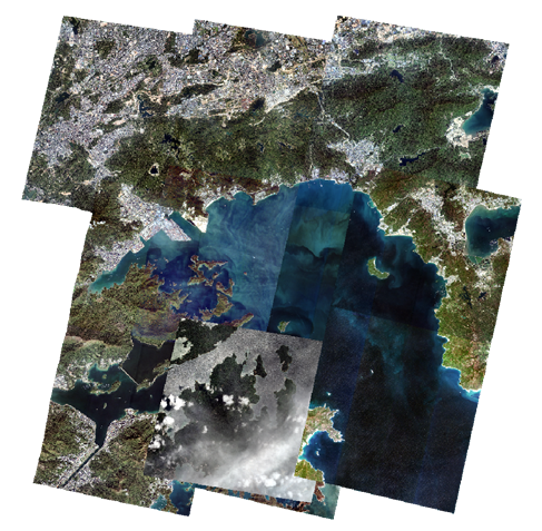
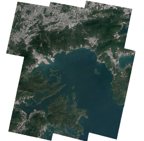
| Figure: Original Image | Figure: Color Balancing Template | Figure: Color Balance Result |
Parameter Description
| Parameter Name | Parameter Interpretation | Parameter Type |
| Data Type |
This parameter is available only when the function is launched from the Imagery tab -> DOM Data Production group -> Image Color Balancing. Select the source of the input image data. Options include Image Files and Mosaic Dataset. The default is Image Files. |
|
| Image Files |
This parameter is available only when the function is launched from the Imagery tab -> DOM Data Production group -> Image Color Balancing. After selecting Image Files in Data Type, you can directly input the local path information, and all images under that path will be automatically retrieved. |
File |
| Image Data Source |
This parameter is available only when the function is launched from the Imagery tab -> DOM Data Production group -> True Color Output. After selecting Mosaic Dataset in Data Type, specify the data source where the image dataset is located. |
Datasource |
| Image Data | After selecting Mosaic Dataset in Data Type, specify the image dataset. If it is a production workflow, only the dataset is displayed and cannot be edited. | DatasetMosaic |
| Color Balancing Method |
Two methods are provided: Template Color Balancing and Adaptive Color Uniformity.
|
|
| Color Balancing Template |
Available after selecting Template Color Balancing in Color Balancing Method. Specify local image files as the template and adjust the color characteristics of the image to be balanced based on this template, ensuring that the colors of the image to be balanced are consistent with or highly similar to the template. |
File |
| Color Balancing Method |
Available after selecting Template Color Balancing in Color Balancing Method. The default is Uniform Light and Color.
|
ColorBalanceMethod |
| Block Size | Default is 1024*1024. Smaller block sizes yield better color balancing results but require more time. | BlockSizeOption |
| Red Band Index | Set the red band. Default is 0. | Integer |
| Green Band Index | Set the green band. Default is 1. | Integer |
| Blue Band Index | Set the blue band. Default is 2. | Integer |
| Brightness | Used to adjust the brightness of the result image. The value range is [-100,100], and the default value is 0.0. A larger value results in a brighter image. | Double |
| Contrast | Used to adjust the contrast of the result image. The value range is [-100,100], and the default value is 0.0. A larger value results in stronger contrast. | Double |
| Saturation | Used to adjust the saturation of the result image. The value range is [-100,100], and the default value is 0.0. A larger value results in stronger saturation. | Double |
| Mask Data | Not selected by default. If selected and mask data is set, the system will exclude that area before outputting the image color balancing results. | Boolean |
| Data Source | Available after selecting Mask Data. Specify the data source where the mask dataset is located.If executing a production workflow, this parameter is not provided. | DataSource |
| Dataset | Available after selecting Mask Data. Specify the mask dataset.If executing a production workflow, the mask data from True Color Output is used by default. | DatasetVector |
| Color Balancing Preview | Not selected by default, meaning the image color balance result is not previewed. If this checkbox is selected, the execution will be paused during workflow production or standalone image color balancing, and the image color balancing effect will be output to the preview window based on the Preview Resolution. | Boolean |
| Color Balancing Resolution |
Available after selecting Color Balancing Preview. Set the resolution for color balancing preview. The default is Reduce by 4 times, which is 1/4 of the original image resolution. You can click the Preview button on the right to view the image color balancing effect. |
OrthoRatioDecreaseMethod |
| Export Directory |
Set the storage path for the result image.
If executing a production workflow, use the Processing path parameter from Set Image Path or Add Orthophoto, and this field is not editable. |
File |
| Resampling Method | Set the image resampling method. Options include Nearest, Bilinear, and Cubic. The default is Bilinear. For more information, refer to Resampling Method. | ResampleMethod |
| Result Minimum Value | Set the minimum pixel value in the result image. The default is 1. | Integer |
| Result Maximum Value | Set the maximum pixel value in the result image. The default is 255. | Integer |
| NoData Value | Set the pixel value for no-data areas in the image. The default is 0.0. | Double |
| Resolution Type |
Specify the method for outputting the resulting image resolution. The default is Original Resolution.
|
OrthoRatioType |
| Output Format |
Set the storage type for the result image. Options include Not Set, Tiff/GeoTIFF, Erdas Image, and PCIDSK. The default is Tiff/GeoTIFF, which means using the original storage type of the image for output. If executing a production workflow, use the Output Format parameter from Set Image Path or Add Orthophoto, and this field is not editable. |
FileType |
| Compression Method |
Set the compression method for the output image. Available only when the output format is Tiff/GeoTIFF. The default is NONE. If executing a production workflow, use the Compression Method parameter from Set Image Path or Add Orthophoto, and this field is not editable. |
CompressMethod |
| Output as Original Image Coordinate | Select this parameter to output the coordinate system of the result data using the image coordinate system of the input data. Otherwise, use the Output Coordinate System parameter from Set Image Path or Add Orthophoto, and this field is not editable. | Boolean |
| Add Results to Map Window |
This parameter is available only when the function is launched from the Imagery tab -> DOM Data Production group -> Image Color Balancing. Selected by default, meaning the result data will be added to the map window for display after successful execution. |
Boolean |
| Create Image Pyramid | Selected by default. Builds pyramids for the image data based on the specified resampling method, improving image zoom display rendering and performance. | Boolean |
| Resampling Method | Available after selecting Create Image Pyramid. The default is Average. For more information, refer to Resampling Method. | ResamplingMethod |
| Asynchronously Create Statistics | During image browsing, the layer will be stretched based on statistics information. If the image does not have statistics information, it will be displayed using the default stretch method, and 8-bit data will not be stretched. Selected by default, meaning statistics will be created for the image in the background without affecting workflow execution. If deselected, statistics will be created while executing this tool, which may consume time. | Boolean |

Output Result
- Output the image data after color balancing processing to the local folder.
- Automatically create an image color balancing mosaic dataset in the OrthoData data source based on the output image data.
Related Topics