


Storage of Time Data
SuperMap maps can play and display temporal data stored in UDB/UDBX Datasource, PostGIS database, Oracle database, etc.
The attribute table of temporal data must contain a time field for storing temporal information. Each element in the table may have a single time field representing an observation timestamp, e.g., a typhoon track point element's time field indicates observation time. Alternatively, two time fields may exist to represent start and end times of observation, e.g., a polygon feature representing flood extent would have both start and end time fields.
Handling Time Fields
Temporal data's time field must be date type for optimal query performance. If existing time fields aren't date-type, you must migrate time values to date-type fields.
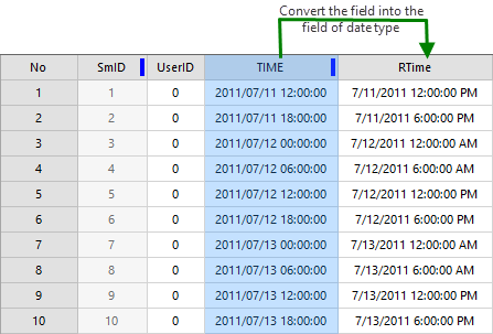 |
| Figure: Time Field in Temporal Data |
Typically, temporal values might be stored in text/string/numeric fields. SuperMap provides conversion functionality to transfer time values from text/string fields (numeric fields currently unsupported) to date-type fields, provided the stored time values follow specific formats for successful conversion.
- Supported time string formats: YYYY, YYYYMM, YYYY/MM, YYYY-MM, YYYYMMDD, YYYY/MM/DD, YYYY-MM-DD, YYYYMMDDhhmmss, YYYY/MM/DD HH:mm:ss, YYYY-MM-DD hh:mm:ss
- Where: YYYY = 4-digit year; MM = 2-digit month (01=January); DD = 2-digit day (01-31); HH = 2-digit hour (00-23, 24-hour format); mm = 2-digit minute (00-59); ss = 2-digit second (00-59)
Follow these steps to transfer non-date time values to date-type fields. For detailed field conversion functions, refer to "Update Column".
- Open the attribute table containing the time field and create a new date-type field to store converted values.
- Use Update Column function on the new date-type field with these parameters:
- Select "Whole Field"
- Choose "Function"
- Select operation field as original time field (e.g., "Time" wide-character field)
- Choose "to_date" conversion function and specify original time format according to supported patterns mentioned above. For example, select "YYYY/MM/DD HH:mm:ss" if time values follow this format.
- Complete type conversion through above operations.
Additionally, indexing date-type time fields can further enhance visualization and query performance.
Formats of Temporal Data
Both vector and image data with temporal attributes can be displayed in SuperMap. Image data must be added to mosaic datasets for temporal playback.
- Vector: Vector data can represent geometries with shape/location changes over time. For example, typhoon track points where each point's time field records observation time. During playback, corresponding points display sequentially along timeline.
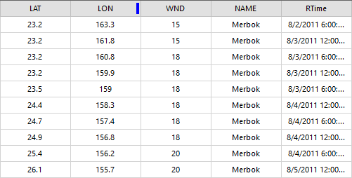
Figure: Typhoon Track Point Temporal Data - Image: Images must be added to mosaic datasets. Use outline dataset's attribute table in mosaic dataset to store temporal values.
First create mosaic dataset and add multi-temporal images. Then create new date-type field(s) in outline dataset's attribute table - one or two fields depending on time characteristics (single timestamp or time range). Finally edit time fields with corresponding values. Example below shows mosaic dataset containing daily satellite cloud images with observation times recorded in Time field.
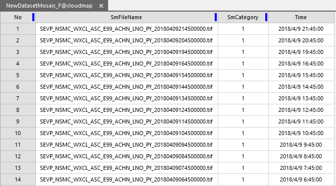
Figure: Adding Time Field to Outline Dataset Attribute Table
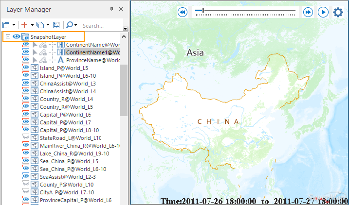
Add Temporal Data to Map
Add temporal data to map and configure layer styles. For styling guidance, see Set Layer Style. When playing temporal data, it's recommended to manage non-temporal layers through snapshot layers to improve display refresh efficiency.
Snapshot layer groups multiple layers that only redraw when map view range changes. During temporal playback (where view range typically remains constant), only time-varying layers refresh, ensuring smoother performance.
 |
Related Topics:
