


Attribute-Spatial Conversion
Text to Field
Adds text from text datasets to their attribute tables by specifying target fields for converted text.
Feature Entry
- Data tab->Data Processing group->Type Conversion->Text to Field.
- Toolbox->Type Conversion->Attribute-Spatial Conversion->Text to Field.
Steps
- In the pop-up Text to Field dialog, select the text dataset to convert and its datasource in the text dataset area.
- Set target fields under Select Fields. For naming conventions, refer to Database Reserved Keywords List.
- Execute conversion after configuration.
Field to Text
- Converts field values to text datasets for map labeling. E.g., convert Name field in Province_R dataset (China datasource) to text for labeling when displayed with Province_R dataset.
- Text position is determined by feature's interior point. Adjust via Text Alignment if needed.
- Supports point/line/region/text/3D point/3D line/3D region/2D network/3D network/model datasets.
Feature Entry
- Data tab->Data Processing group->Type Conversion->Field to Text.
- Toolbox->Type Conversion->Attribute-Spatial Conversion tool: Field to Text.
Steps
 |
- In the Field to Text dialog, set target datasource, dataset name, and fields to convert.
- Execute conversion after configuration.
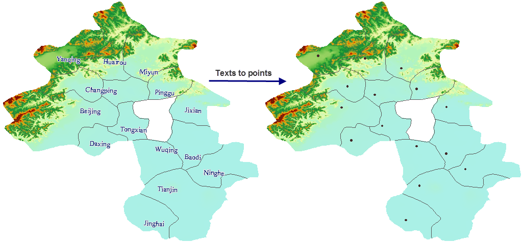
Text to Point
Extracts text anchor points to create point datasets. Anchor points relate to text alignment (set via Styles tab->Text Style group). See: Set Text Style.
Feature Entry
- Data tab->Data Processing group->Type Conversion->Text to Point.
- Toolbox->Type Conversion->Attribute-Spatial Conversion tool: Text to Point.
Steps
 |
- In the Text to Point dialog, select source dataset and set target dataset name/datasource.
- Execute conversion after configuration.
Attribute to Point
Creates point datasets using X/Y coordinate values from attribute fields.
Feature Entry
- Data tab->Data Processing group->Type Conversion->Attribute to Point.
- Toolbox->Type Conversion->Attribute-Spatial Conversion tool: Attribute to Point.
Steps
- In the Attribute to Point dialog, select vector dataset and set target dataset name/datasource.
- Select X/Y coordinate fields whose values will generate point coordinates.
- Execute conversion after configuration.
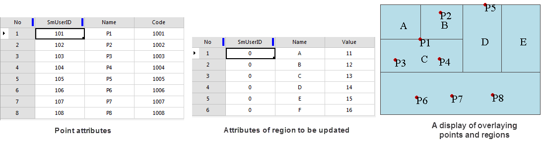
Point Attribute to Polygon
Updates polygon attributes with point attributes (non-system fields). When multiple points exist in a polygon, randomly selects one point and adds StaticInfo field recording point count.
- Transfers SmUserID and all non-system fields from points.
- Updates existing same-name/type fields; creates new fields if names/types differ.
Feature Entry
- Data tab->Data Processing group->Type Conversion->Point Attribute to Polygon.
- Toolbox->Type Conversion->Attribute-Spatial Conversion tool: Point Attribute to Polygon.
Steps
 |
- In the Point Attribute to Polygon dialog, select datasets and set target dataset name/datasource.
- Execute conversion after configuration.
- Observe attribute tables:
- Common fields: SmUserID, Name
- Unique fields: Code (points), Value (polygons)
- Different values in common fields
Conversion results:
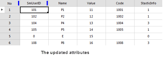
- Added Code field and StaticInfo field
- Original Value field unchanged
- StaticInfo shows contained point count
- Polygons A/B/C/D/F updated with P1/P2/P4/P5/P8 attributes
Related Topics
CAD/Composite-Simple Data Conversion