GPA (abbreviation for Geo-Processing Automation)
Refers to connecting a series of geographic data processing tools through certain logical relationships to build a model that can be processed automatically.
Model Builder
Used to create, execute, and manage GPA models, including the following parts:
Menu
Provides menu options for model building and operations.
Parameter Panel
Used to set and adjust parameters of tool nodes.
Toolbox
Stores all available data processing and analysis tools, including: data import, data export, data processing, spatial analysis, spatial statistics, online analysis, etc., and also supports adding Python custom tools.
Modeling Canvas
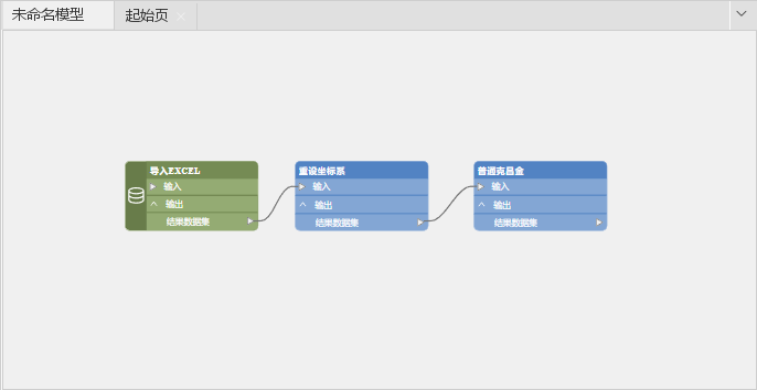
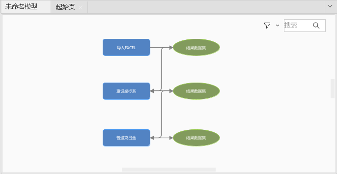
Used for dragging tools to build a visual interface for models. SuperMap iDesktopX 2025 has redesigned the canvas interaction experience, seamlessly integrating output ports into tool/variable nodes. This design significantly reduces the number of nodes, minimizes visual clutter, and makes the logic clearer.
You can experience the new canvas style by checking the New GPA Canvas checkbox in the Experience function group under the Options group in the File tab.
 |
 |
| Figure: New Canvas Style | Figure: Traditional Canvas Style |
Task Manager Window
Used to monitor and manage the execution of GPA models, including the following:
Task List
Lists all running and completed models.
Execution Progress
Displays the current execution progress and status of the model.
Execution Log
Records details during model execution, including error and warning messages.
GPA Model
Is a flowchart formed by connecting a series of GPA tools according to business logic, where the output of each tool serves as the input for the next tool. The model consists of the following elements:
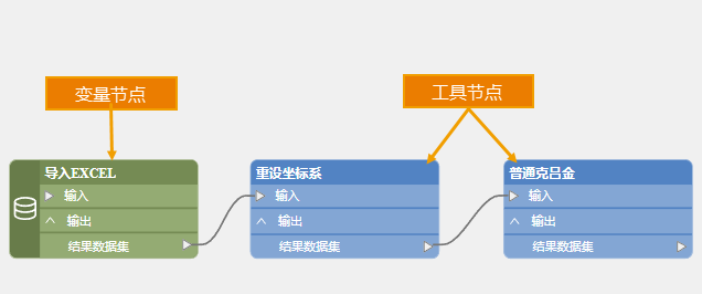
Tool Nodes
A single tool in the model, used to perform specific data processing tasks. In the new canvas style, the core functional modules of tool nodes mainly include data management, processing, analysis, etc. These nodes achieve data flow between nodes through data sources.
Variable Nodes
Nodes that store specified values in the model, such as data connection information, real-time dates, etc. In the new canvas style, the core functional modules of variable nodes mainly include variable definition, data import/export, etc. They support direct transfer of native values and provide a local file pass-through channel to achieve data format conversion, improving data processing efficiency.
As shown below, variable nodes and tool nodes are distinguished using green and blue.
You can experience the new canvas style by checking the New GPA Canvas checkbox in the Experience function group under the Options group in the File tab.
 |
 |
| Figure: Node Division in New Canvas Style | Figure: Node Division in Traditional Canvas Style |
Parameters
In tool nodes and variable nodes of the model, used to define input data parameters, functional parameters, and output result parameters.
Connectors
Lines used to establish logical relationships between tools in the model, supporting parameter transfer or control of execution order. When connecting two tools, specify the specific parameters of the tool to achieve parameter transfer from the output of the previous tool to the next tool. If "pre-condition" is selected, it only defines the execution order without transferring parameters, meaning the tool before the "pre-condition" connector is executed first, followed by the tool after it.
Model Metadata
Used to describe the basic information of the model, including the scope of application, usage methods, etc., which are important for understanding and using the model.
Model Library
Used to centrally store and manage multiple models, supporting the addition of authorization codes to ensure safer and more controllable sharing of models.
Related Content


