


With the advancement of satellite and aerial remote sensing image resolution, more valuable data and information can be extracted from remote sensing imagery. Different applications require distinct approaches to remote sensing image processing. To effectively analyze and manage these datasets, content-based image labeling becomes essential, with scene classification serving as a crucial solution.
Scene classification categorizes image data based on specific characteristics, differentiating areas with similar features and assigning scene labels to each image. The core challenge lies in effective feature extraction.
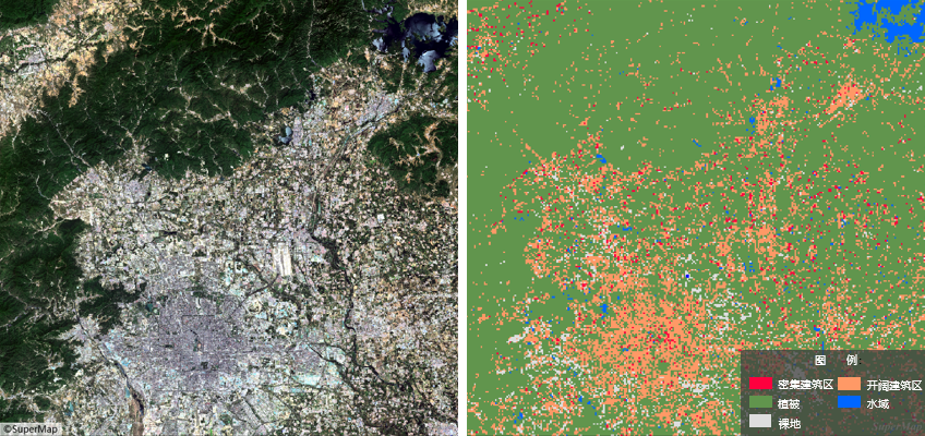
The output of scene classification is a uniformly sized vector grid (32×32 pixels), where each grid cell contains the scene label for its corresponding image area. This represents a coarse-grained classification method below pixel-level resolution, typically employed for large-scale tasks like urban local climate zone classification.
Main Parameters
Local Climate Zone (LCZ), a novel theoretical framework for urban heat island studies, finds applications in urban planning and meteorological modeling. The scene classification function divides urban areas into regular grids (32×32 pixels), using neural networks to infer grid types. The illustration below demonstrates LCZ classification results in Beijing, where red indicates compact building areas, orange represents open building zones, green denotes vegetation, white signifies bare land, and blue marks water bodies.
- Function Entry: Toolbox-> Machine Learning-> Imagery Analysis-> Scene Classification tool.
- File Type: Supports dataset or folder selection for batch processing to enhance efficiency. Default: Dataset.
- Datasource/Dataset: Required when selecting Dataset type. Choose target imagery or mosaic dataset.
- File Path: Required for Folder type. Automatically reads *.tif, *.img files in specified directory.
- Model File: Select scene classification model file (*.sdm).
- Batch Size: Number of images processed per inference step. Default: 1. Higher values increase memory/VRAM usage but reduce processing time.
- Processor Type: Choose between Central Processing Unit (CPU) or Graphics Processing Unit (GPU). GPU accelerates computation.
- GPU ID: Specify GPU device number. Default: 0. Supports multi-GPU processing.
- Advanced Parameters: Enable to configure spatial constraints.
- Bounds Dataset/Datasource: Enables custom boundary inference using vector dataset extents.
- Result Data: Specifies output vector dataset storage location and name.
- Execution: Click Run to initiate classification. Progress updates display in Python console.
Related Topics
 Machine Learning Environment Configuration