


Perform multiple classification on imagery by analyzing spectral information and spatial characteristics of various ground objects in remote sensing images. This process assigns semantic category labels to each pixel, enabling identification of features including buildings, forest land, grassland, paddy fields, and agricultural land. Similar to binary classification, multiple classification utilizes neural network models to determine which predefined category each pixel belongs to, thereby identifying multiple ground object types and calculating the location, boundaries, and area of target categories through pixel analysis.
Application Scenario
Multiple classification is widely used in land cover monitoring applications such as deforestation tracking, urbanization monitoring, as well as infrastructure detection for traffic management, urban planning, and road surveillance.
Main Parameters
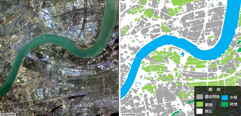
The following figure shows multiple classification results for a specified area, where gray represents built-up areas, blue indicates water bodies, light green denotes cultivated land, dark green signifies forest land, and white corresponds to other types.
- Function Entry: Toolbox-> Machine Learning-> Imagery Analysis-> Multiple Classification tool.
- File Type: Supports dataset or folder selection for batch processing to improve efficiency. Default: Dataset.
- Datasource/Dataset: Required when File Type is Dataset. Select target imagery or mosaic dataset.
- File Path: Required when File Type is Folder. Specify directory containing *.tif, *.img, or other supported image formats.
- Model File: Select multiple classification model file (*.sdm).
- Tile Overlap (pixel): Default 0. Recommended value: 1/8 to 1/4 of tile size to mitigate edge prediction artifacts. Larger overlaps increase processing time.
- Batch Size: Number of images processed per iteration. Default 1. Higher values increase memory/vRAM usage but reduce processing time within hardware limits.
- Processor Type: Choose between Central Processing Unit (CPU) or Graphics Processing Unit (GPU). GPU accelerates computation.
- GPU Number: Specify GPU device ID for processing. Default 0. Supports multi-GPU configurations.
- Other Parameter Settings: Enable to configure bounds parameters.
- Bounds Dataset/Datasource: Perform custom boundary inference using vector dataset extent.
- Result Data: Configure output raster dataset parameters including datasource and filename.
- Run: Click Run to execute. Progress information displays in Python console.
Related Content
 Machine Learning Environment Configuration