


Binary classification utilizes spectral information from various ground objects in remote sensing imagery and spatial data to identify specific target elements through deep learning algorithms. It determines whether image pixels belong to the target category, generating binary raster data with values 0 (non-target) and 1 (target).
This function performs pixel-level interpretation with fine granularity, producing highly flexible raster results. The classification outcomes can be refined through post-processing steps and converted into vector data for advanced analysis.
Common applications include extracting distinct features like roads, rivers, and buildings. It enables calculation of target category locations, boundaries, and areas through pixel analysis.
Main Parameters
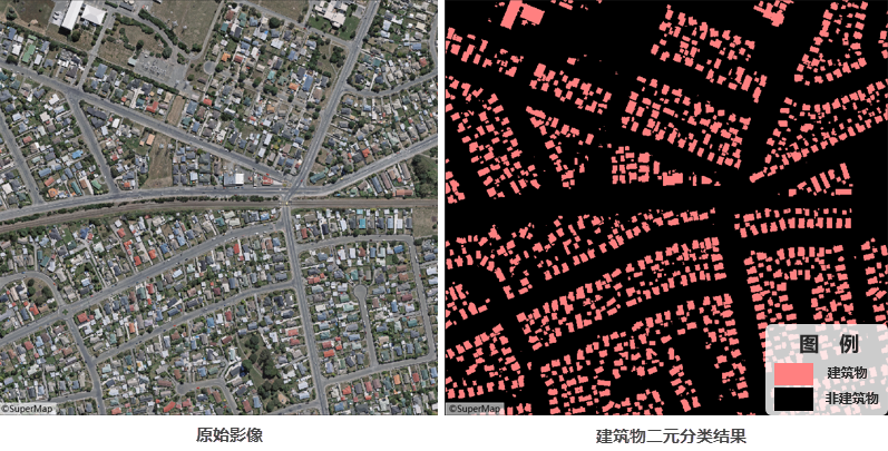
The following illustration shows binary classification results for buildings in a specific area. Building areas can be calculated through raster statistics, while discrete structures can be vectorized to obtain spatial locations and boundary information.
- Function Entry: Toolbox-> Machine Learning-> Imagery Analysis-> Binary Classification tool.
- File Type: Supports Dataset or Folder selection for batch processing. Default: Dataset.
- Datasource/Dataset: Required when selecting Dataset. Choose target imagery or Mosaic Dataset.
- File Path: Required for Folder selection. Automatically reads *.tif/*.img files in directory.
- Model File: Select binary classification model file (*.sdm).
- Tile Overlap (pixel): Default 0. Recommended 1/8-1/4 of tile size to mitigate edge prediction issues. Larger overlaps increase processing time.
- Batch Size: Number of images processed per iteration. Default 1. Higher values increase memory usage but reduce processing time.
- Processor Type: Choose between CPU or GPU (recommended for faster computation).
- GPU ID: Specify GPU device number. Default 0. Supports multi-GPU processing.
- Advanced Settings: Enables bounds configuration:
- Bounds Dataset/Datasource: Perform inference within specified vector boundaries.
- Result Data: Configure output raster dataset name and storage location.
- Execution: Click Run to initiate process. Progress displays in Python console.
Related Topics
 Machine Learning Environment Configuration