


Cameras and their captured videos possess spatial geographic information. Before overlaying videos with GIS data for mapping and analysis, spatial registration is required to transform image coordinates into geospatial coordinates, calibrate the geographic spatial range of videos, and establish mapping relationships between video image space and geographic space. iDesktopX provides real-time coordinate transformation capabilities between video and map coordinates. When PTZ cameras rotate shooting angles or adjust zoom levels, it can perform coordinate transformations for videos and geofences in real-time based on camera parameters like azimuth, pitch angle, and field of view, eliminating time-consuming manual adjustments and conversions.
Principles of Video Registration
Video presents geographic space with strong realism, making spatial registration the most critical aspect of GIS-video integration. SuperMap iDesktopX employs the pinhole camera model, discovering the "key cipher" for communication between video pixels and GCS, achieving mutual transformation between video pixel coordinates and geospatial coordinates. It can spatialize videos using both internal/external camera parameters and calibrate videos without camera parameters to assign GCS information.
 |
| Figure: Pinhole Imaging Technology |
Registration Methods
- Calibration Registration: Links the position of the registration dataset to the reference data by adding control points. Mainly applicable to videos captured by fixed cameras.
- Camera Parameter Registration: Completes video registration by importing camera parameters or subtitle files. Primarily used for non-fixed-point shooting videos.

Video Parameter Specifications
- Lat and Lon: X/Y coordinates representing the geographic position of the camera.
- Height: Absolute elevation or relative height of the camera.
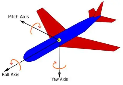
- Yaw Angle: Angle between camera direction and true north (0° at north, -180° at south, increasing clockwise).
- Pitch Angle: Angle between camera axis and horizontal plane (0° for horizontal shooting, negative values for downward angles, -90° for vertical nadir).
- Roll Angle: Angle between aircraft symmetry plane and vertical plane of fuselage longitudinal axis (positive for right deviation).
- FovX: Horizontal field of view (in degrees).
- FovY: Vertical field of view (in degrees).
This chapter covers:
Calibration Registration: For fixed-point video registration (online/offline). Explains fixed-point video spatial calibration.
Camera Parameter Registration: For UAV video registration (online/offline, zoom videos currently unsupported). Demonstrates registration using camera parameters.
Camera Parameter Registration Example: Illustrates UAV video registration workflow.
Calibration Registration Example: Demonstrates fixed-point rotating video registration process.
SuperMap UAV Survey Video Registration: Explains SuperMap UAV Survey video registration workflow.