Modify 3D Ranges Map
Instructions for use
You can edit the style of the Graudated Colors Map in the 3D Ranges Map "window. Here is how to modify the 3D Ranges Map.
Operation steps
- Set Segmentation expression: Set the Thematic variable of the current Graudated Colors Map in the Segmentation expression "check box. You can also customize the Thematic variable in Expression in the drop-down box.
- Select segmentation method: Displays and sets the segmentation method of the current 3D Ranges Map when segmenting all thematic values determined by the Thematic variable. Select the appropriate segmentation method from the drop-down list in the combo box on the right.
- Equal Interval: Based on the maximum and minimum values of all thematic values determined by the Thematic variable, the segments are divided at equal intervals according to the "number of segments" set by the user. In an Equidistant Interval, each segment has an equal length.
- Square Root Interval: Equidistant interval is performed on the segmented data of the square root of the thematic value determined by the Thematic variable. Firstly, take the square root of all thematic values, and then carry out Equidistant Interval to obtain the segmentation points of the processed data, and then square the values of these segmentation points to obtain the segmentation points of the corresponding thematic values, so as to obtain the segmentation scheme of the thematic values.
- Standard Deviation Interval: reflects the deviation of a certain attribute value of each object from its average value. First, calculate the mean and standard deviation of the thematic values determined by the Thematic variable, and then segment them. The length of each segment of the Standard Deviation Interval is One Standard Deviational, the middle segment is centered on the mean, and the left and right segment points are 0.5 standard deviations from the mean, respectively. The "number of segments" obtained by the Standard Deviation Interval method is determined by the Calculate Result and cannot be controlled by the user.
- Logarithmic Interval: is basically the same as the Square Root Interval method, but the difference is that the Square Root method takes the square root of the thematic value, while the Logarithmic Interval method takes the logarithm of the thematic value. That is, an Equidistant Interval is performed on the base-10 logarithm of the thematic value. Firstly, perform Equidistant Interval on the logarithms of all thematic values to obtain the segmentation points of the processed data, and then take 10 as the base, and take the values of these segmentation points as the power of the exponent to obtain the values of each segmentation point of the corresponding thematic values, so as to obtain the segmentation scheme.
- Quantile Interval: Each range segment has an equal number of Object Counts, which is determined by the user-specified Number of Segments and the actual Object Count in the layer used to make the Graudated Colors Map. Records should be the same in each segment when they can be divided equally, but when they cannot be divided equally, the segmentation results will be different in the last segment.
- Custom Interval: The user specifies the length of each segment, that is, the "single segment length" for segmentation. The "number of segments" is calculated by the application system according to the specified interval distance and the maximum and minimum values of the thematic value, and cannot be controlled by the user.
- Adjust the number of segments Displays and sets the number of segments that the current 3D Ranges Map segments the thematic value, i.e., the number of the final range segments.
- Single Segment Length: Displays and sets the interval distance of the current 3D Ranges Map segment, that is, the length of each range segment. The setting of this item is valid only when the segmentation method is Custom Interval.
- Segment title format: Specify the format for expressing the value range of each range segment. Two formats are mainly provided, which can be selected and set through the combo box on the right.
- Set Color Scheme: Change the overall color style of the current 3D Unique Values Map by selecting a gradient band in the Color Scheme "box. You can also customize your preferred ribbon style with the Customize option in the drop-down box.
- All range segments are listed in the lower part of the Merge or Split Range Segments: tab. You can merge and split each range segment as needed.
 The button is used to merge the selected multiple continuous range segments (the Ctrl or Shift key can be used together) into one range segment. The range range of the merged range segment is the union of the range ranges of all the merged range segments. If none or only one range segment is selected, or the selected range segments are not continuous, this button is unavailable.
  The button is used to split a selected range segment into two new range segments.
- Set whether the sub-items of the thematic map are visible: Refer to the dynamic interface. After selecting one or more sub-items of the thematic map, you can click
 the icon button to set whether the selected sub-items of the thematic map are visible. You can also adjust the visibility of thematic map children by clicking the status icon in front of
  them.
them. - Set the display style of thematic map sub-items: Select one or more thematic map sub-items by referring to the dynamic interface, and click the "Style" button for Style Settings. A point layer thematic map can activate a Point style editor by clicking a
 button, The line layer thematic map activates the Line Symbol Selector by clicking a
  button, The surface layer thematic map activates the Fill Symbol Selector by clicking
  the button.
 - To select multiple thematic map subitems, press the Ctrl key and then click the thematic map subitems in turn, or press the Shift key and click the pre-selected head and tail in the thematic map subitem list to select all thematic map subitems between the head and tail.
- After selecting several thematic map subitems, click the "Style" setting button in the toolbar to pop up the "Modify Thematic Map Subitem Style" dialog box, where you can select the items to be modified for batch modification. Please refer to Change Style for details.
- Set the extension property of the sub-items of the thematic map: Select one or more sub-items of the thematic map to be extended, and click
 the icon button to pop up the Thematic Map Sub-item Extension Property Settings "window. You can set the extended attributes and mapping of the 3D Thematic Map. Please refer to the Thematic Map Subitem Extension Property Settings for details.
 - Adjust Segment Value: The Segment Value spin box under the Toolbar displays the value of the segment point (the end point of the segment) of each range segment (as shown in the figure above). Each spin box corresponds to a segment point. The value of the segment point can be changed through the spin box. The changed results are reflected on the current Graudated Colors Map layer in real time.
- Set the title content of the sub-item of the thematic map: The title content of the sub-item of the thematic map can be modified. Select the title content of the sub-item of the thematic map to be edited, and then click the text box of the title content to become editable.
- Instant Refresh Settings: By default, the "Enable Instant Refresh" Settings "is enabled, and the user's Style Settings for each step of the theme map layer will be displayed in the scene instantly. The user can also cancel the "Enable Instant Refresh" "check box and click the" Apply "button to apply the customized Parameter Settings to the current thematic map.
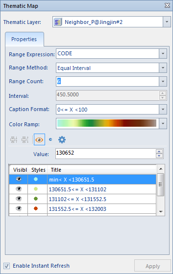 | 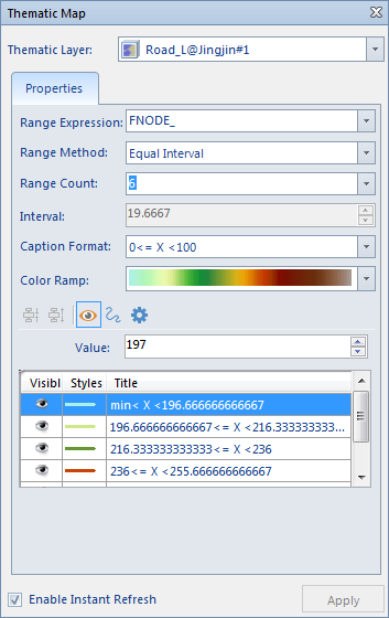 | 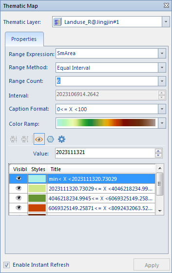 |
| 3D Ranges Map Based on Point Layer | Making 3D Ranges Map Based on Line Layer | 3D Ranges Map Based on Surface Layer |
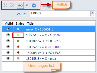 | 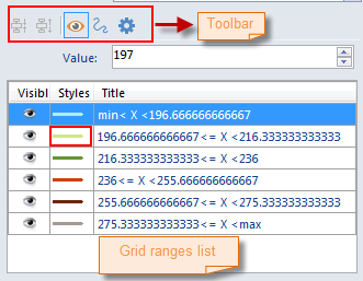 | 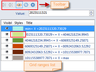 |
| 3D Ranges Map "Window Based on Point Layer | 3D Ranges Map "Window Based on Line Graph Layer | 3D Ranges Map "Window Based on Face Layer |
Remark
The 3D Thematic Map produced and modified by the user can be saved as a template so as to be applied to the production of thematic maps of other 3D layers. Please refer to Save to Thematic Map Template. for specific operation of Save as thematic map template.
 Related topics
 Making 3D Ranges Map Based on Template
 Save to Thematic Map Template Library


