 Instruction
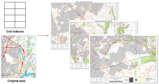
A map series is a collection of maps. iDesktop allows you to generate a map series by traversing a group of map ranges. For example, based on a regular grid layer (index layer), iDesktop can create a series of pages convering cities and towns in the same areas.
 |
 Enable Map Series
Before enabling a map series, you need to add a map into your layout. The size of the map frame determines the display scale of each map on each page of a map series. The range of each map in every page is centered on each index feature and keeps a constant map proportion.
If you will print your layout strictly in accordance with the grid size, please adjust the map frame size properly. For details about how to fill a map in a layout, please refer to Draw a map.
- Function Entrances:
- Entrance 1: In a layout window, click Objection Operations tab > Map Series group > Map Series Settings button.
- Entrance 2: In a layout window, right-click your mouse and select Map Series.
In the popup panel "Map Series Settings", check the checkbox Enable to enable a map series. Likewise un-check it to disable the feature.
 Parameter Specifications
- Index Map: Choose the map you want from the dropdown list. All map frames are listed here, but only one can be selected once. The range of map in the map frame will change over each page of a map series and is drove by the spatial range of each feature in the index layer.
- Index Layer: Defines the geographical range of each map on each page. The index polygons in the index layer are used for controlling or defining each page of a map series.
The function Create Grid Index can create a index layer. The first layer in your map is adopted by default. You can select another layer as well.
The index layer can either grid data or a region layer. If it is a region layer, each grid index range is based on the feature's spatial envelop. For example, you can create corresponding page for each administrative division based on an administrative region dataset.
- Index Field: iDesktop will traverse polygons in the index layer and takes attribute values of the index field as page names after all pages being defined. The name of a page can be empty or the same as another one's. But using unique values is recommended to get rid of the confusion.
The dropdown menu lists all available fields of the index layer. The default index field is the first field with "name" in its name. If there are no fields with "name" in their names, the index field will be the first available field by default.
- Current Page: The name of the first page is by default. You can switch to other pages by choosing corresponding items from the dropdown list.
Next, you can add dynamic text and draw a map locator in the layout.
