 Instructions
Calculate values of adjacent polygons of each polygon and save them in an attribute table.
8 fields will be added for your region dataset. Each field indicates a direction of 8 directions illustrated in the following picture. The feature calculates values of adjacent regions of each polygon in different directions.
 |
| An illustration of 8 directions |
Application scenarios
The feature is usually used for labeling adjacent pages.
Function entrances
- Entrance 1: Open a map window, click Maps tab > Mapping gallery > Calculate Adjacent Fields.
- Entrance 2: Open a layout window, click Objection Operations tab > Map Series group > Calculate Adjacent Fields.
 Parameter description
- Datasource/Dataset: Specify which dataset will involve the calculation. The generated result will be added corresponding grid index objects.
- Field Name: Specify which field will be used for filling adjacent field data.
- Generated result: 8 fields will be produced in the attribute table of the input dataset. Every field name combinates the name of the field you specify and direction. Such as you set Field Name to GridTitle, the reulting fields are GridTitle_N, GridTitle_NE, GridTitle_E, GridTitle_SE, GridTitle_S, GridTitle_SW, GridTitle_W, and GridTitle_NW.
 Instances
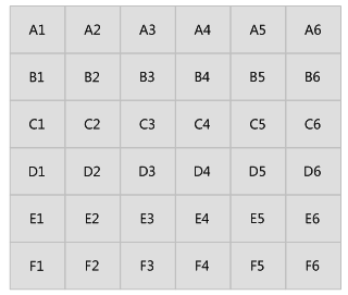
Set the input dataset to the dataset generated by performing the feature Create Grid Index. Set Field Name to PageName. After executing the feature, the resulting fields are PageName_N, PageName_NE, PageName_E, PageName_SE, PageName_S, PageName_SW, PageName_W, and PageName_NW.
According to the following picture, we can find out adjacent values of the grid B1 are A1 (North), A2 (NorthEast), B2 (East), C2 (Southeast), and C1(South).
 |
 |
| Figure 1: The grid index dataset | Figure 2: The calculated result |
