


Used to measure the distance, area, or angle between points on the map. For raster data, it also supports measuring surface distance, surface area, or surface volume.
During measurement, users can enable the Snapping function for more precise positioning of points to be measured.
Invalid surfaces do not support map measurement.
Functional Entry
- Map Tab -> Actions Group.
Unit
It is recommended to set the measurement unit before performing measurements. Click the Map Tab -> Actions -> Unit button, and set the units for distance, area, and angle respectively in the dialog box that pops up.
Provides Automatic Unit Conversion. The measurement results will be automatically converted within their respective systems. For example: when the current measurement unit is decimeters, and the measurement result is greater than or equal to 10 decimeters, the result will be displayed in meters; when the measurement result is greater than or equal to 1000 meters, the result will be displayed in kilometers.
Distance Measure
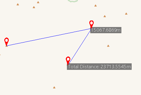
Distance measure includes three types: straight line, geodesic line, and surface distance:
- Euclidean Distance refers to the horizontal distance between any two points on the map in a two-dimensional planar space, without considering the earth's curvature. When the map uses a geographic coordinate system, using straight-line distance measurement results in significant errors; it is recommended to use geodesic distance measurement.
- Geodesic Distance refers to the length of the shortest line on the ellipsoidal (spheroidal) earth's surface between any two points on the map. For example, it can be used to measure the shortest path distance between two city airports, serving as a flight route.
The SmLength field in the attribute table and the length value in object properties also use geodesic resampling methods.
- Surface Distance refers to measuring the distance on the three-dimensional surface fitted by raster data along a specified line segment or polyline. The distance measured by surface distance is along the curved surface, which is greater than both Euclidean distance and geodesic distance.
Using Euclidean Distance measurement as an example, the following describes how to complete distance measurement:
- Select the Euclidean Distance option from the Map Measurement drop-down menu. The mouse cursor changes to a crosshair in the current map.
- Click the left mouse button at the starting point of the distance to be measured to set the measurement start point. Move the mouse; a temporary line segment connecting the current mouse point and the start point will appear on the screen, along with the length value of this segment.
- Move the mouse to the position of the second measurement point and click the left mouse button to confirm the second point.
 Note:
Note:During measurement, the map simultaneously displays two result values: the length of the line segment between the current mouse point and the previous point, and the total length of the polyline from the current mouse point to the measurement start point.
- Before clicking the second point, these two values displayed on the map are equal.
- After clicking the second point, moving the mouse causes the two values displayed on the map to change (they become unequal).
- The length of the line segment between the current mouse point and the previous point is always less than the total length of the polyline from the current mouse point to the start point.
- Repeat step three to add the remaining measurement points. After adding the endpoint, right-click to complete the measurement operation.
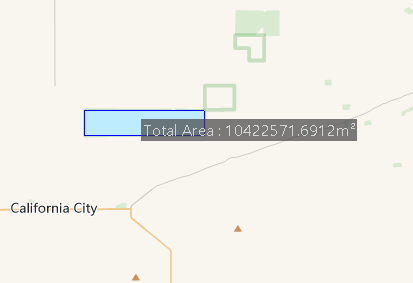
Area Measure
Area measure includes planar area and Surface Area. Surface area refers to measuring the area of the surface fitted by raster data. The following uses planar area measurement as an example:
- Select the Area option from the Map Measurement drop-down menu. The mouse cursor changes to a crosshair in the current map.
- Click the left mouse button at the boundary of the area to be measured in the current map to set the start point for area measurement.
- Click the left mouse button at the turning points along the boundary of the area to be measured to draw the second point of the polygon.
- Repeat step three, and right-click to complete the polygon drawing.
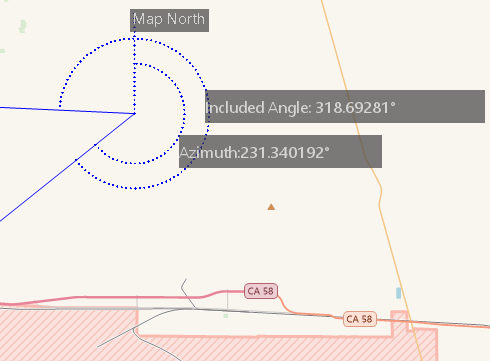
Angle Measure
Used to measure the value of the included angle between consecutive line segments.
- Select the Angle option from the Map Measurement drop-down menu. The mouse cursor changes to a crosshair in the current map.
- In the current map, click the left mouse button on any point on one side of the angle to be measured as the starting point. A dashed line pointing to true north appears at this point. Moving the mouse creates a ray from the starting point, and the azimuth angle between this ray and the true north dashed line is displayed.
- Use the left mouse button to select the vertex of the angle to be measured, thus defining one side. Moving the mouse creates a ray from the second mouse point, forming an angle with the first side. At this point, two angle measurement values are displayed: the included angle between this ray and the first side, and the azimuth angle of this ray.
- Click the left mouse button on any point on the other side of the angle to be measured, then right-click to complete the angle measurement. The angle values of multiple consecutive lines can be measured continuously.
Clear
Click the Clear button in the Actions group to clear the temporary polylines/polygons and the numerical labels of measurement results in the current map. Additionally, pressing the Esc key also achieves the clear function.
Related Topics