Thematic Map Subitem Extension Property Settings
Instructions for use
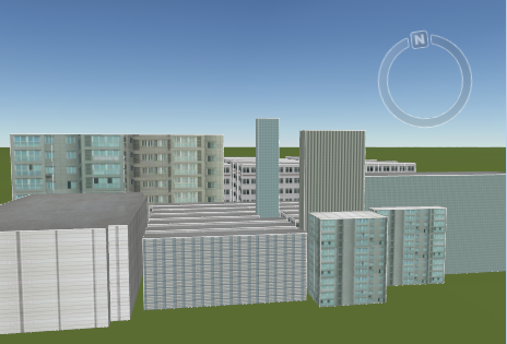
The Thematic Map Subitem Extension Property Settings function is used to set the extension properties of the Thematic Map Subitem and the Texture Map properties. Different Display Effects can be obtained for each Model Object by setting different extension attributes for each sub-item of the thematic map. Display Effects is shown in the following figure:
 |
Currently supports setting of extended attributes for 3D Unique Values Map and 3D Ranges Map.
Operation steps
- In the 3D Thematic Map window, select one or more thematic map subitems for which Property Settings are to be performed, and click the Subitem Extension Property Settings "button
 . Go to the Thematic Map Subitem Extension Property Settings "window.
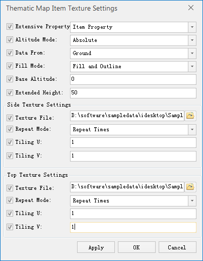
 - Set the type used by the extended property, which is consistent with the thematic map layer or Item Property. By default, the extended attributes of the sub-items of the thematic map are consistent with the thematic map layer. Other Property Settings are valid only if they are set to Item Property.
- Consistent with Layer Property: indicates that the extension attributes of the sub-items in the thematic map are consistent with the extension attributes of the thematic map layer. That is, consistent with the properties in the Extended Properties group of the Layer Properties tab in the Ribbion.
- Item Property: The child items selected in the thematic map window will use the attributes set in the "Thematic Map Child Extended Property Settings" "window, while the other child items will use the extended attributes of the thematic map layer.
- Change the height mode to the non-ground mode, that is, change the height mode to the Absolute, Relative to Ground mode according to the actual needs. For a description of the height mode, see About the height mode .
- Set Data Type, aboveground or underground. Note: This property is available only when the height mode is not ground contact.
- Set the Fill Mode of the subitem. Three methods are provided: Fill, Outline, and Filling and Outline. They are used to set the mapping Fill Mode of the selected subitem.
- Sets the Bottom Altitude value and Extended Height of the current subkey. For an introduction to Bottom Altitude and Extended Height, see Set Bottom Altitude and Extended Height.
- Sets the side (top) map of the current child, including the repeat mode of the side (top) map, the path where the map is located, and the Horizontal Repeat Times and Vertical Repeat Times.
- Map Source: The location of the map image. The absolute path where the Select Picture is required.
- Repeat mode: 2 repeat modes are provided, Repeat Times and Real Size.
Repeat Times: refers to the number of times the map is repeatedly placed, which is divided into horizontal Repeat Times and vertical Repeat Times.
Real Size: refers to mapping using the Real Size of the map, which is divided into horizontal size and vertical size.
- Horizontal (Vertical) Repeat: The number of times the map is repeated horizontally (vertically). You can enter a positive integer to specify the horizontal Repeat Times of the picture.
- When the settings are complete, click the OK button to run and exit the current settings window.
 |
| Figure: Thematic Map Subitem Extension Property Settings "Window |
Remark
- Multiple thematic map subitems can be selected at the same time, and their extended attributes can be set uniformly. After setting, if you need to modify one of the parameters, just select the check box in front of the parameter and modify it directly. Other unmodified content remains the original setting.
- In order to highlight the realistic effect of the map, it is recommended to use the foreground color of the Modify Thematic Map subitem style to achieve better Display Effects.
 Related topics
 To map the surface of an object


