


Fusion Production Workflow
The Fusion Production Workflow used to perform pan-sharpening (fusion of panchromatic and multispectral data) on raw imagery, output as fused results for one or multiple independent scenes. It is applicable where the core requirement is to obtain imagery with precise geographic location and high spatial detail for a specific area, while strictly maintaining the original pixel physical meaning or radiometric consistency for quantitative analysis.
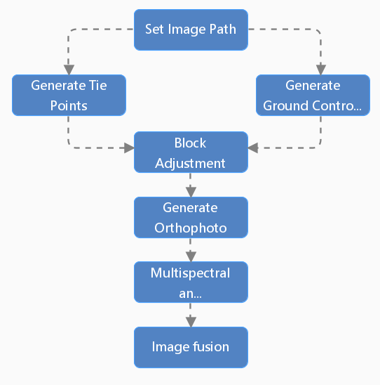
- Set Image Path: Specify the processing paths for raw imagery, reference imagery, and result data. Supports filtering and pairing of raw panchromatic and multispectral images.
- Generate Tie Points: Automatically generates tie points in overlapping image areas for mosaicking and block adjustment of multiple satellite images, ensuring geometric consistency among them.
- Generate Ground Control Points: Generates Ground Control Points based on image feature points for high-precision geometric correction and geolocation, ensuring the geographic positional accuracy of the imagery.
- Block Adjustment: Calculates the orientation parameters of the satellite images through adjustment computation based on the tie points and ground control points.
- Generate Orthophotos: Orthorectifies the imagery to remove geometric distortions caused by terrain relief and sensor attitude, producing a panchromatic orthophoto.
- Multispectral and Panchromatic Registration: Registers the multispectral imagery to the corrected panchromatic image, ensuring precise spatial alignment between the panchromatic and multispectral data.
- Image Fusion: Performs pan-sharpening (or other fusion techniques) to combine the panchromatic and multispectral images, enhancing image quality by integrating their respective spatial and spectral details.
 |
| Figure:Fusion Production Workflow |