


Feature Description
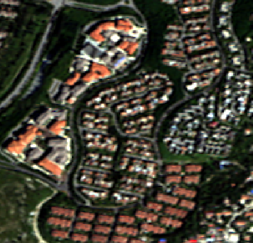
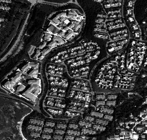
Image fusion is a technology that uses various methods to composite and transform multiple images from different times, different sensor systems, different resolutions, and different spectral bands to generate new images. For example, after fusing a panchromatic orthoimage with a multispectral orthoimage, a high-quality image with both high spatial resolution and high spectral resolution can be obtained. This technology effectively combines the advantages of various images, providing richer information support for subsequent analysis and applications.
 |
 |
 |
| Figure: Multispectral before fusion | Figure: Panchromatic before fusion | Figure: Multispectral after fusion |
Parameter Description
| Parameter Name | Parameter Interpretation | Parameter Type |
| Data Type |
This parameter is available only when the function is launched from the Satellite image processing tab -> DOM Data Production group -> Image Fusion. Select the source of input image data, providing two options: Image Files and Mosaic Dataset. The default is Image Files. You can manage image files using the Add, Select All, Select Reverse, Delete, and Settings functions in the Image file list.
|
|
| Panchromatic Data Source |
This parameter is available only when the function is launched from the Satellite image processing tab -> DOM Data Production group -> Image Fusion. Specify the data source where the panchromatic image data is located after selecting Mosaic Dataset in Data Type. |
DataSource |
| Panchromatic Data | Specify the mosaic dataset where the panchromatic image data is located after selecting Mosaic Dataset in Data Type. If it is a production workflow, it is display-only and not editable. | DatasetMosaic |
| Multispectral Data Source |
This parameter is available only when the function is launched from the Satellite image processing tab -> DOM Data Production group -> Image Fusion. Specify the data source where the multispectral image data is located after selecting Mosaic Dataset in Data Type. |
DataSource |
| Multispectral Data | Specify the mosaic dataset where the multispectral image data is located after selecting Mosaic Dataset in Data Type. If it is a production workflow, it is display-only and not editable. | DatasetMosaic |
| Fusion Method |
Specify the image fusion method. The default method is Gram-Schmidt.
|
FusionMethod |
| Predefined Fusion Weights | Check this checkbox to use predefined weights for fusion. This is only effective for PanSharp and Gram-Schmidt methods. If unchecked, adaptive weights will be used for fusion. | Boolean |
| Sharpening Factor | Used to adjust the sharpness of the fused image. The default is 1. | Double |
| Resampling Method | Set the resampling method after image fusion. Provides three options: Nearest, Bilinear, and Cubic. The default is Bilinear. For more method descriptions, please refer to Resampling Method. | ResampleMethod |
| Export Directory |
Set the storage path for the result image. If executing a production workflow, use the Processing parameter in Set Image Path or Add Orthophoto, and this field is not editable. |
File |
| Output Format |
Set the storage type of the result image. Provides four options: Not Set, Tiff/GeoTIFF, Erdas Image, and PCIDSK. The default is Tiff/GeoTIFF. Selecting Not Set means using the original storage type of the image for output. If executing a production workflow, use the Output Format parameter in Set Image Path or Add Orthophoto, and this field is not editable. |
FileType |
| Compression Method |
Set the compression method for the output image. Only available when the output format is Tiff/GeoTIFF. The default is NONE. If executing a production workflow, use the Compression Method parameter in Set Image Path or Add Orthophoto, and this field is not editable. |
CompressMethod |
| Add Results to Map Window |
This parameter is available only when the function is launched from the Satellite image processing tab -> DOM Data Production group -> Image Fusion. Checked by default, meaning that after the function executes successfully, the result data will be added to the map window for display. |
Boolean |
| Create Image Pyramid |
Checked by default, it can build pyramids for the image data according to the specified resampling method, thus improving the zoom display rendering and performance of the image. If executing a production workflow, use the Create Image Pyramid parameter in Set Image Path or Add Orthophoto, and this parameter is not displayed. |
Boolean |
| Resampling Method |
Available when Create Image Pyramid is checked. The default is Average. For more method descriptions, please refer to Resampling Method. If executing a production workflow, use the Resampling Method parameter in Set Image Path or Add Orthophoto, and this parameter is not displayed. |
PyramidResampleType |
| Asynchronously Create Statistics |
When browsing an image, the layer will be stretched based on statistical information. If the image has no statistical information, it will be displayed according to the default stretch method, and 8-bit data will not be stretch-displayed. Checked by default, meaning that statistics will be created for the image in the background without affecting workflow execution. If unchecked, statistics will be created simultaneously when executing this tool, which may consume time. If executing a production workflow, use the Asynchronously Create Statistics parameter in Set Image Path or Add Orthophoto, and this parameter is not displayed. |
Boolean |
Output Result
- Output image data that combines features of both panchromatic and multispectral images to a local folder.
- Automatically create an image fusion mosaic dataset in the OrthoData datasource based on the output image data.
Related Topics
Multispectral and Panchromatic Registration