


The commonly used coordinate systems include 1954 Beijing Coordinate System, 1980 Xi'an Coordinate System, WGS 84 Geodetic Coordinate System, and the currently required 2000 National Geodetic Coordinate System. The parameters for each coordinate system are listed below:
| Coordinate System | Reference Ellipsoid | Semi-Major Axis | Flattening |
| 1954 Beijing Coordinate System | Krasovsky | 6378245 | 1:298.3 |
| 1980 Xi'an Coordinate System | IAG-75 International Ellipsoid | 6378140 | 1:298.257 |
| WGS 84 | WGS 84 | 6378137 | 1:298.257223563 |
| 2000 National Geodetic Coordinate System | CGCS2000 | 6378137 | 1:298.257222101 |
The above parameters indicate that the four coordinate systems differ in their reference ellipsoid foundations and datums. Consequently, the coordinate values for the same Earth position vary across different systems. When converting data between coordinate systems, it's crucial to understand the rigor of transformation: coordinate transformations within the same ellipsoid are rigorous, while those between different ellipsoids are non-rigorous. For instance, transforming geodetic coordinates in the 1954 Beijing Coordinate System to Gauss-Krüger plane coordinates within the same reference spheroid constitutes a rigorous process. However, transformations between the 1954 Beijing Coordinate System and 2000 National Geodetic Coordinate System belong to inter-ellipsoid conversions that lack universally applicable parameters across all Earth positions. Therefore, spatial points must be transformed between different reference ellipsoid datums using conversion models. The datum transformation process essentially involves solving transformation parameters. Only after obtaining these parameters and performing coordinate system conversions within the same ellipsoid datum can complete data transformation be achieved; otherwise, data accuracy cannot be guaranteed.
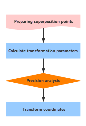
Coordinate Transformation Technical Process
- Preparation: Collect and organize common point coordinate data for transformation. Analyze and select reliable common points with high precision. The number of common points should meet requirements and be evenly distributed across the survey area.
- Transformation Parameter Calculation: Determine the conversion model based on existing common point results and transformation requirements. Use redundant common points with least squares method as constraints to calculate transformation parameters.
- Accuracy Analysis: Calculate target coordinate system coordinates for common points using transformation parameters. Analyze conversion residuals (differences between transformed and known coordinates). Evaluate transformation accuracy by computing mean square error of residuals. Eliminate gross errors using residual tolerance limits (3×mean square error). Recalculate parameters with new common points if accuracy assessment fails.
- Coordinate Transformation: Compute coordinates for other features in target coordinate system using validated transformation parameters.
 |
Notes:
|