


Feature Description
A new workspace will be created by default when starting the desktop application. This new workspace can be saved to the local path or database through the Save/Save Workspace As operation to complete the creation of the workspace.
At the same time, SuperMap provides the functionality of creating workspace from template. The workspace created by template is consistent with all the elements including the datasource, dataset, map, layout and scene in the template workspace.
The datasource name, projection and other attributes of the created workspace are consistent with the datasource in the template; The Dataset number, type, name, table structure, projection, character set, code, value domain and other attributes in the created datasource are the same as the dataset in the template; Dataset object count in new workspace is 0, layer bounds is empty, index type is no spatial index.
Steps
The steps to create workspace from template are as follows:
- Start tab-> Workspace group-> File drop down-> Create workspace from template
- In the Create Workspace from Template dialog that pops up:
- Target Dataset: Used to set the save path and name of the new workspace, and the created datasource will be saved to the same directory.
- Templates: Provides Cadastral Vectorization template to choose from:
- Current Workspace: Use current workspace as a template.
- Local Workspace: Select a workspace in the local file as the template.
- Template Workspace: SuperMap provides Cadastral Vectorization template.
- Cadastral Vectorization template helps to generate the following:
-
Two datasources created based on templates: MapManager and VectorManager
- The datasets created under these datasources are all established in line with standard cadastral vectorization workflow.
- Each dataset's attribute table includes standard preset fields to help users quickly vectorize cadastral map.
- Three maps created based on the template: Map_CadastralVector, Map_PointCheck and Map_ClipBounds. The map has preconfigured layer orders and styles for all datasets. Once data is loaded, they can be visualized directly in the map window.
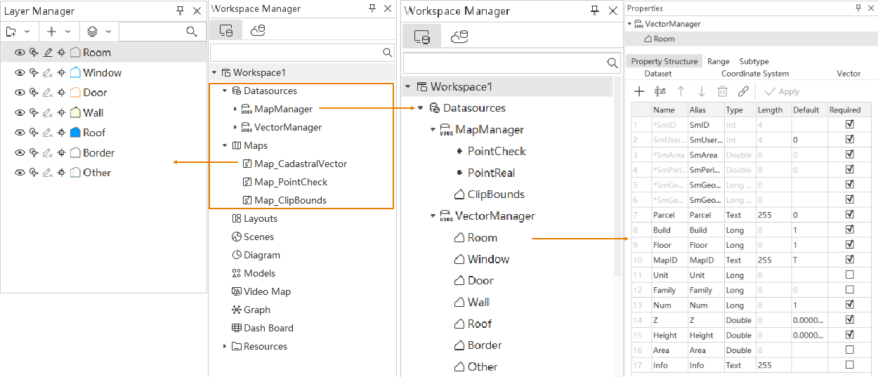
-
Related Topics