


Join Features can append attributes from one dataset to another based on spatial, temporal, attribute relationships, or their combinations. The datasets can be spatial data or attribute tables. This tool first identifies all input features that meet the specified join conditions, then appends matching features from the join dataset to the source dataset.
The Join Features tool transfers and appends information from one layer to another. Features can be joined based on spatial, attribute, temporal relationships, or combinations of these criteria.
Spatial Relationships
Determines spatial relationships between features. Available relationships depend on the geometry types (point, line, or polygon) of the layers being joined. Supported spatial relationships include: Adjacent, Contain, Within, Cross, Intersect, Overlap, Touch, Disjoint, Identity. For details, refer to Spatial Query Operators.
| Spatial Relationship | Diagram | Description |
|---|---|---|
| Adjacent |  |
Features meet the condition when the join feature is within the specified distance radius from the source feature. |
| Contain | 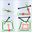 |
The source feature completely contains the join feature. |
| Within | 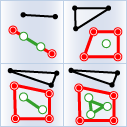 |
The source feature is completely contained by the join feature. |
| Cross |  |
The source feature crosses the join feature. |
| Overlap | 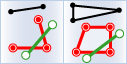 |
Features of the same geometry type (point, line, or polygon) overlap. |
| Intersect | 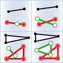 |
The source feature intersects with the join feature. |
| Touch | 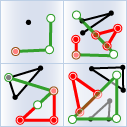 |
Features share common points or edges. |
| Disjoint | 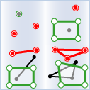 |
Features have no spatial intersection. |
| Identity |  |
Features of the same geometry type coincide completely. |
Temporal Relationships
| Temporal Relationship | Diagram | Description |
|---|---|---|
| Near | 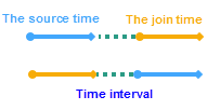 |
Source time is considered near join time when within a specified temporal range. |
| After |  |
Source time occurs after join time within a specified interval. |
| Before | 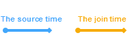 |
Source time occurs before join time within a specified interval. |
| Contain | 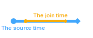 |
Source time interval contains the join time. |
| During | 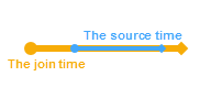 |
Source time occurs within the join time interval. |
| Finish | 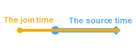 |
Source time ends simultaneously with join time but starts later. |
| Finishedby |  |
Source time ends simultaneously with join time but starts earlier. |
| Meet | 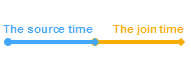 |
Source time starts with join time and ends before join time interval. |
| Metby | 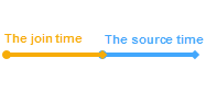 |
Source time starts with join time and extends beyond join time interval. |
| Overlap |  |
Source time starts before and ends during join time interval. |
| Overlapedby | 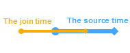 |
Source time starts during and ends after join time interval. |
| Start | 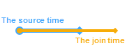 |
Source time starts with join time and ends earlier. |
| Startedby |  |
Source time starts with join time and ends later. |
| Equal | 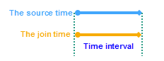 |
Two time intervals have identical start and end points. |
Application Scenarios
- Analyze fund transaction flows and calculate total amounts transferred to the same account within specified periods.
- Append district information (school zones, police precincts, communities) to crime incidents for impact analysis across different administrative areas using Join Features.
Feature Entry
- Online Tab -> Analysis Group -> Join Features.
Steps
- iServer Address: Select iServer address and login credentials from dropdown. For details, see Data Input.
- Source Dataset: The target dataset to receive joined attributes. Select from dropdown. See Data Input for configuration details.
- Join Dataset: Required. The dataset providing attributes to append. Supports point, line, and polygon datasets. See Data Input for configuration.
- Analysis Settings:
- Join Type: Required. Defines how source features match with join features:
- One-to-One: Updates source features with attributes from the first matching join feature. If multiple matches exist, only counts are recorded.
- One-to-Many: Preserves all matching join features in result dataset. E.g., a source feature matching five join features will generate five output records.
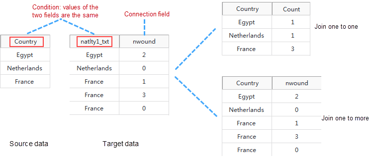
- Join Field: Field from join dataset used for feature matching.
- Join Type: Required. Defines how source features match with join features:
- Feature Association Methods: Join features using spatial, temporal, attribute relationships, or combinations:
- Spatial Feature Join: Define spatial relationships based on geometry types (Adjacent, Contain, Within, etc.).
- Time Feature Join: Define temporal relationships (moment or interval). See temporal relationships above.
- Time Step Unit: Required. Units include seconds, milliseconds, minutes, hours, days, weeks, months, years (default: seconds).
- Property Feature Join: Match features where specified field values are equal (or not equal) between datasets.
- Attribute Statistics Field: Calculate statistics (max, min, average, sum, variance, standard deviation) for selected fields. Multiple fields require corresponding statistical modes.
- Statistical Mode: Select statistical method(s) from dropdown.
- Tolerance: Applies to "Adjacent" spatial relationships. E.g., with 100m distance and tolerance=1m, features within 99-101m are matched.
- After parameter setup, execute Join Features. Results will auto-display on map. The output window shows workspace path for result dataset. Note: Directly opening results from iServer may fail due to locked files. Copy data to another location for editing.
Related Topics