


Instructions for Use
The Style Migration function is used to batch migrate Symbol and Color Ramp resources from ArcMap *.style symbol library files to SuperMap iDesktopX, enabling seamless reuse of user data assets.
During GIS data production and mapping, users often accumulate a large number of custom symbols and color ramp resources in ArcMap. When migrating to the SuperMap platform, the inability to reuse these resources would lead to repetitive creation, consuming significant time and effort. This function parses the Marker Symbol Library and Color Ramp resources within *.style files and converts them into a format supported by the SuperMap platform, helping users preserve historical assets and improve mapping efficiency after data migration.
Version Information: Starting from SuperMap iDesktopX 2026, the original "Symbol Migration" function has been upgraded to "Style Migration", supporting the simultaneous migration of symbols and color ramps.
ArcGIS and SuperMap Symbol Systems Overview
ArcGIS Symbol Types
Based on the geometry type used for drawing, ArcGIS symbols can be categorized into four types: Marker, Line, Fill, and Text. A combination of various symbols is collectively called a Style, which is saved as a single file (*.style).
- Marker Symbols: Used for drawing point features and point graphics.
- Line Symbols: Used for drawing linear data, such as transportation networks, water supply systems, boundaries, zones, and other connected networks.
- Fill Symbols: Used for drawing polygon features, such as countries, provinces, land use areas, habitats, parcels, and contour lines.
- Text Symbols: Used for drawing labels, annotations, titles, dynamic text, descriptions, notes, legends, scale bars, graticule labels, tables, and other text and tabular information on maps.
SuperMap Symbols
SuperMap provides a rich symbol library, including three types: point symbols, line symbols, and fill symbols. It supports various symbol style settings and complex hierarchical management. It also supports SVG format import, and symbol vectorization solves issues like icon blur on high-resolution screens.
Symbol Type Support
| ArcGIS Symbols | SuperMap Symbols | Support Status | |
| Marker Symbols | SimpleMarkerSymbol | Simple Symbol | √ |
| CharacterMarkerSymbol | TrueType Symbol | √ | |
| PictureMarkerSymbol | Raster Symbol | √ | |
| MultiLayerMarkerSymbol | Multi-layer TrueType Symbol | √ | |
| 3D Marker Symbols (3D Character Marker Symbol, 3D Marker Symbol, 3D Simple Marker Symbol) | -- | × | |
| Line Symbols | SimpleLineSymbol | Simple Line Symbology | √ |
| CartographicLineSymbol | Dash Gap Symbol | √ | |
| HashLineSymbol | Custom Line Symbol |
Simple line symbology is supported, but virtual-real mode display effects may be inconsistent. Complex line symbols are not supported. |
|
| MultiLayerLineSymbol | Multi-layer Gap Line Symbol | √ | |
| Picture Line Symbol | -- | × | |
| 3D Linear Symbols (3D Simple Line Symbol, 3D Texture Line Symbol) | -- | × | |
| Fill Symbols | SimpleFillSymbol | Pure Filling | √ |
| LineFillSymbol | Picture Symbols |
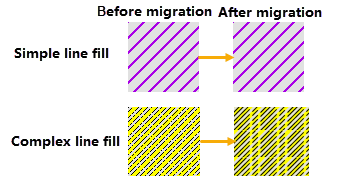
Simple line fill symbols are supported. Complex line fill symbols are not supported.
|
|
| MarkerFillSymbol | Symbol Filling | Partially Supported | |
| GradientFillSymbol | System Fill Symbol + Gradient Style | √ | |
| PictureFillSymbol | Picture Symbols | √ | |
| MultiLayerFillSymbol | Symbol Filling | √ | |
| 3D Texture Fill Symbol | -- | × | |
Color Ramp Migration
In addition to symbol resources, this function synchronously migrates color ramp resources from *.style files. The migrated color ramps can be automatically loaded into the Color Scheme Manager, maintaining consistent color styles for easy direct use in subsequent mapping.
For some special color ramp types in ArcMap, the system processes them using the following parsing logic:
| Color Ramp Type | Parsing Description |
|---|---|
| Random Color Ramps | Random color ramps in ArcMap have non-fixed colors, making it impossible to obtain their specific color values, thus preventing complete migration. During migration, the system randomly generates a color ramp with the same number of colors as the preview color ramp in ArcGIS. |
| Multi-layer Color Ramps | When the color ramp types within a multi-layer color ramp are inconsistent, the system migrates based on thetype definition of the first layer: • If the first layer isGradient, all subsequent colors are migrated as gradients. • If the first layer isSingle Color, all subsequent colors are migrated as single colors (the gradient level takes the starting color). |
Function Entry
- Data Migration Tab -> ArcGIS Data Migration -> Style Migration.
Operation Steps
- Open the Tool: Open the "Style Migration" dialog via the entry point above.
- Add Source Files:
-
Click the Add File button and select one or more *.style files in the pop-up file selection dialog. File filtering only displays *.style format files.
-
Or click the Add Folder button to select a folder containing *.style files. The system will recursively scan all *.style files in that folder and its subfolders.
-
-
Set Migration Options and Storage Path:
-
Migrate the Symbol Library: Checked by default. When checked, you must specify the storage path for the symbol library, defaulting to the product package installation directory. If you change the storage path, the system will remember and apply the last selected location the next time you use it. Uncheck to skip symbol library migration.
-
Migrate Color Ramps: Checked by default. When checked, you must specify the storage path for the color ramps, defaulting to the Product Package Directory/templates/ColorScheme/UserDefine/[style file name] folder.Warning: Color ramps stored in the default path will be automatically loaded into the "Custom" group in the Color Scheme Manager. If you change the storage path, you need to manually import the color ramp file. Uncheck to skip color ramp migration.
-
-
License Verification: Select the ArcMap license type. "Default" represents non-official license types for ArcMap. You can click the Check button to see if the corresponding ArcGIS license information exists on the current machine.
-
Execute Migration: Click the OK button to begin style migration execution.
- View Migration Results:
- Output Information: After migration is complete, the output window will display result information, including storage paths for the symbol library and color ramps.
- Migrated Symbol Library Results
- Symbol library files are stored in the specified Symbol Library Storage Path , including:
-
Marker Symbol Library: *.sym files
-
Line Symbol Library: *.lsl files
-
Fill Symbol Library: *.bru files
-
-
For use, you need to import the symbol library files from the corresponding path in the SuperMap Symbol Library Manager.
Point/Line Symbol Migration Comparison:

Fill Symbol Migration Comparison:

- Symbol library files are stored in the specified Symbol Library Storage Path , including:
- Color Ramp Migration Results:
Storage Method Storage Location Display Effects Default Path Product Package Directory/templates/ColorScheme/UserDefine/[style file name]/ Automatically loaded into the Color Scheme Manager, displayed under a group named after the {style file name} in the "Custom" category. The color ramp names remain consistent with before migration. Custom Path Any path specified by the user Not automatically loaded. Requires manual import in the Color Scheme Manager, or the files can be directly copied to the default path for use.
Related Topics