


Conventional GIS applications mainly operate through GIS desktop software or industry-specific desktop applications developed based on GIS components. These applications manage fundamental geographic information data and business data using file-based or database-based storage methods. On one hand, applications can be developed using a C/S architecture, where the system directly interacts with the data storage for read and write operations. On the other hand, applications can adopt a B/S architecture, where data is published as standardized REST services for frontend web applications to access. Additionally, with technological advancements and increasing user demands for efficient web service access, map tile technology has been gradually adopted to enhance the efficiency of map service access.
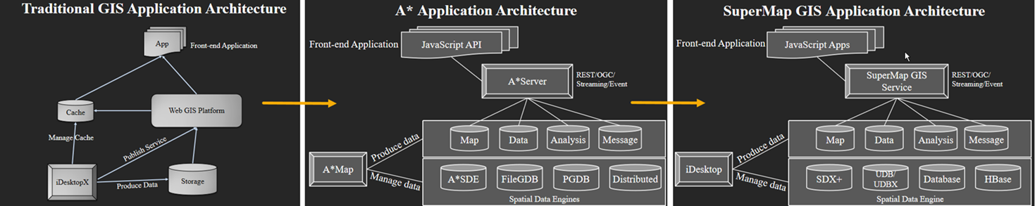
When applying conventional GIS applications based on the ArcGIS platform, ArcGIS Desktop (ArcMap) is primarily used for data processing. Geographic spatial data is stored and managed through Geodatabase, enabling users to develop desktop applications using ArcObjects or ArcGIS Engine to directly read Geodatabase data, thus implementing C/S architecture industry applications. Alternatively, Geodatabase data can be cartographically processed according to industry standards, generating map documents (MXD), which are then published as ArcGIS REST services via ArcGIS Server. These services can be accessed through web applications developed using the JavaScript API provided by ArcGIS, forming a B/S architecture industry application. Additionally, ArcMap provides a tile-cutting tool to generate map tiles, which can be used to publish cached map services, improving web application access efficiency.
In summary, to replace the ArcGIS platform, we need to migrate ArcGIS platform data in terms of data management, map documents, map tiles, and map services.
- Data Management: Generally, data is stored and managed based on the ArcGIS Geodatabase data model, which includes various sub-data models such as surface, network, and mosaic datasets. Therefore, the Geodatabase-supported data models need to be replaced with corresponding SuperMap data models. Additionally, these data are physically stored as personal, file, or enterprise-level Geodatabases, requiring conversion to the corresponding physical storage formats in SuperMap.
- Map Documents: ArcGIS stores a large amount of map-related information in MXD files, including colors, symbols, styles, labels, and various types of thematic maps. The objects stored in MXD files, which adhere to different industry-specific cartographic standards, need to be converted and expressed using SuperMap's cartographic elements and stored in SuperMap's map document file format.
- Map Tiles: SuperMap provides the ability to read ArcGIS map tile packages, enabling the parsing and display of map tiles.
- Map Services: At the web application level, ArcGIS Server's REST services are primarily used, covering various service types such as map services, feature services, and analysis services. To minimize the cost of platform replacement compared to replacing upper-layer applications, it is necessary to ensure that SuperMap GIS Server can publish REST service types compatible with ArcGIS. This enables seamless support for upper-layer applications developed with the ArcGIS API.
License Verification
When using the ArcGIS migration module functions, SuperMap iDesktopX automatically verifies whether the required ArcGIS license is available on the computer. If the necessary license is missing, a prompt will appear: "ArcGIS license loading failed, please check the license status." The required licenses are as follows:
- If the ArcGIS version used on the computer is 10.4, 10.6, 10.7, or 10.8, an ArcServer license is required.
- For other ArcGIS versions, an Advanced license is required.
Data Inspection
When migrating ArcGIS data or maps, SuperMap iDesktopX inspects the data type and layer type to be migrated. SuperMap supports the following data and layer types:
Supported ArcGIS Data Types and Corresponding SuperMap Data Types:
| ArcGIS Data Type | SuperMap Data Type |
| esriDTFeatureDataset | 2D/3D Point, Line, Polygon, and Text Dataset |
| esriDTFeatureClass | 2D/3D Point, Line, Polygon, and Text Dataset |
| esriDTTable | Attribute Table |
| esriDTRasterDataset | Image Dataset |
| esriDTNetworkDataset | Network Dataset |
| esriDTMosaicDataset | Mosaic Dataset |
Supported ArcGIS Vector Layer Types and Corresponding SuperMap Layer Types:
| ArcGIS Vector Layer | SuperMap Vector Layer |
| SimpleRenderer | Standard Vector Layer |
| UniqueValueRenderer | Unique Value Thematic Map |
| ChartRenderer | Statistical Thematic Map |
| ClassBreaksRenderer | Classified Thematic Map |
| FDOGraphicsLayer | Standard Text Layer |
Supported ArcGIS Raster Layer Types and Corresponding SuperMap Layer Types:
| ArcGIS Raster Layer | SuperMap Raster Layer |
| RasterUniqueValueRenderer | Raster Unique Value Thematic Map |
| RasterClassifyColorRampRenderer | Raster Classified Thematic Map |
| IRasterStretchColorRampRenderer | Standard Raster Layer |
Note: The following ArcGIS data and layer types are not supported for import:
| Unsupported ArcGIS Data Types |
| esriDTAny |
| esriDTContainer |
| esriDTGeo |
| esriDTGeometricNetwork |
| esriDTTopology |
| esriDTText |
| esriDTRelationshipClass |
| esriDTRasterBand |
| esriDTTin |
| esriDTCadDrawing |
| esriDTRasterCatalog |
| esriDTToolbox |
| esriDTTool |
| esriDTTerrain |
| esriDTRepresentationClass |
| esriDTCadastralFabric |
| esriDTSchematicDataset |
| esriDTLocator |
| esriDTMap |
| esriDTLayer |
| esriDTStyle |
| esriDTLasDataset |
| ArcGIS Vector Layers That Do Not Support Import |
| DotDensityRenderer |
| ProportionalSymbolRenderer |
| ScaleDependentRenderer |
| RepresentationRenderer |
| BiUniqueValueRenderer |
| ArcGIS Raster Layers That Do Not Support Import |
| RasterColormapRenderer |
| RasterDiscreteColorRenderer |
| RasterRGBRenderer |
This chapter will introduce the following contents:
- Environment Configuration: Introduces how to configure the environment required for ArcGIS migration.
- Database Migration: Explains how to convert ArcGIS Geodatabase data types into corresponding SuperMap datasource types.
- Map Migration: Describes how to migrate ArcGIS map documents, symbols, etc., to SuperMap.
- Service Migration: Explains how to migrate ArcGIS services into SuperMap services.
- Tile Migration: Describes how to migrate ArcGIS TPK tile cache files into SuperMap tile format.
- ArcGIS Pro Migration: Introduces how to migrate ArcGIS Pro project files (*.arpx) into SuperMap iDesktopX workspace files (*.smwu).