


Text to field
To add the Text Info in the Text Dataset to its property sheet, you need to specify the field where the Text Info is saved after conversion.
Function Entry
- Data tab-> Data Processing group-> Type Conversion-> Text to Field.
- Toolbox-> Type Conversion-> Attribute and Spatial Data Conversion-> Text to Field.
Operating Instructions
- On the pop-up Text to Field dialog, select a Text Dataset to be converted and its Datasource in the Text Dataset area.
- Set Select Fields in Field. See List of reserved keywords for the database for naming conventions for fields and Datasets.
- Once the setup is complete, the conversion operation can be performed.
Field to text
- Change the content of a certain field in the Dataset to Text Dataset. Map annotation can be realized through this function. For example, we can convert the Name field of the Province _ R Dataset under China Datasource into Text, and display the Text and the Province _ R Dataset in the same window. O as to realize the marking of the Province _ R Dataset.
- The position of the text after the field to the text is determined by the interior point of the object to which it corresponds. If the position of the converted text is not ideal, it can be adjusted by changing the TextAlignment method.
- Applies to points, lines, faces, text, 3D points, 3D lines, 3D faces, 2D Network Data, 3D Network Dataset, and Model Dataest.
Function Entry
- Data tab-> Data Processing group-> Type Conversion-> Field to Text.
- Toolbox-> Type Conversion-> Attribute and Spatial Data Conversion tool: Field to Text.
Operating Instructions
 |
- On the popup Field to Text dialog, Set the Datasource to be saved, the Dataset Name, and the field to be transferred out of the converted Dataset.
- Once the setup is complete, the conversion operation can be performed.
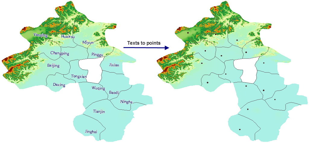
Text to point data
Extract the anchor point of Text to generate a new Point Dataset. The anchor is related to the Alignment of the text. The anchor point of the text, that is, the alignment base point of the text, can be the upper left corner, the lower left corner, etc. Of the text. The anchor position of the text can be set by Alignment in the Text Style group of the Style Settings tab. For details, see: Set the style of Text .
Function Entry
- Data tab-> Data Processing group-> Type Conversion-> Text to Point.
- Toolbox-> Type Conversion-> Attribute and Spatial Data Conversion tool: Text to Point.
Operating Instructions
 |
- The Text to Point dialog box pops up. In the dialog box, set the Dataset to be converted, the Resulting dataset name, and the stored Datasource.
- Once the setup is complete, the conversion operation can be performed.
Attribute data to point data
One or more Point Datasets are generated by specifying the values of the fields in the attribute table as X, Y coordinate values and creating corresponding point objects accordingly.
Function Entry
- Data tab-> Data Processing group-> Type Conversion-> Attribute to Point.
- Toolbox-> Type Conversion-> Attribute and Spatial Data Conversion tool: Attribute to Point.
Operating Instructions
- The Attribute to Point dialog box pops up. Set the Vector Dataset to be converted, the Resulting dataset name and the stored Datasource in the dialog box.
- Select the X and Y coordinate fields. The value of each field is the X and Y coordinate value of the corresponding point in the generated Point Dataset.
- Once the setup is complete, the conversion operation can be performed.
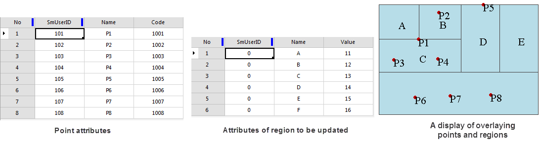
Point attributes to face attribute
To convert a point attribute to a face attribute is to update the Non-system Field: value in the point data attribute to the attribute of the corresponding face data. This function is to update the point Attribute in the face object to the face attribute. If a face contains multiple points, a point will be randomly selected and its Attribute will be updated to the face object. A StasticInfo Statistic Field is added to count the number of points contained in each face object.
- The content of the transformation includes the SmUserID in the point attribute and the Attributes of all Non-system Field:.
- If the face Property Field and the point Property Field have the same name and type, the point Property Field value is updated directly into the face Property Field; If the face Property Field is inconsistent with the point property Type or there is no field with the same name, a new field with the same name and type will be created in the face property, and then the value of the point Property Field will be updated to the face Property Field.
Function Entry
- Data tab-> Data Processing group-> Type Conversion-> Point Attribute to Polygon.
- Toolbox-> Type Conversion-> Attribute and Spatial Data Conversion tool: Point Attribute to Polygon.
Operating Instructions
 |
- In the pop-up Point Attribute to Polygon dialog box, set the Dataset to be converted, the Resulting dataset name and the stored Datasource in the dialog box.
- Once the setup is complete, the conversion operation can be performed.
- It can be seen from the property table of Point Dataset and Region Dataset that:
- Point Dataset and Region Dataset have two same fields, SmUserID and Name;
- The Point Dataset has a separate field Code, and the Region Dataset has a separate field Value; Same field values for
- Point Dataset and Region Dataset are not the same.
updating, the following results are obtained:
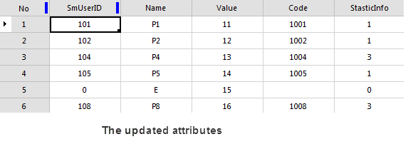
- Added a field Code from Point Dataset and a system-generated record field StaticInfo; The value of the original separate field Value of the
- Region Dataset has not changed;
- The StaticInfo field value is the same as the number of update points in the face; The attributes of the
- faces A, B, C, D, F are updated by the points P1, P2, P4, P5, P8, and the SmUserID and Name values are updated to the attribute values of the corresponding point objects.
Related topics
Interconversion of CAD, composite data and simple data
2D data and 3D Data Conversion