


In the Electronic Chart Display System (ECDIS), water depth Show Settings is one of the important functions to ensure the safety of ship navigation. These settings help navigators to accurately judge the navigation safety of ships in different waters by controlling the display of isobaths and depth points on the chart.
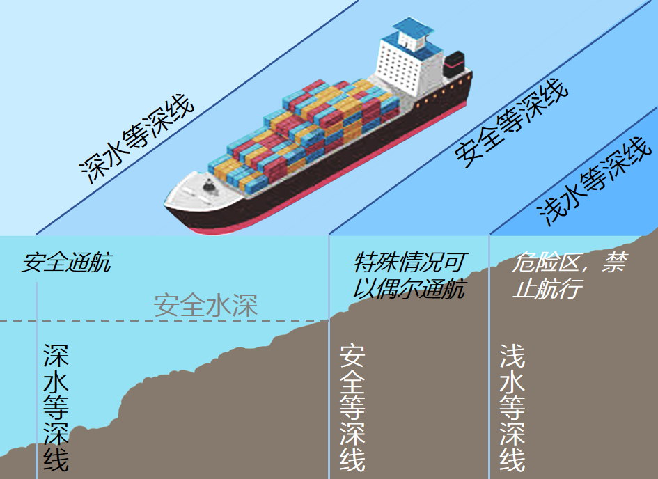
The core of water depth Show Settings includes four key parameters: (point) safe water depth and (line) safe isobath, shallow water isobath and deep water isobath.
Safety Depth
Since a "safe area" where the water depth is greater than safe isobath may also have a location where the water depth is shallower, such as a submerged reef, indicating an unsafe water depth point plays an important supporting role for safe navigation. The navigator needs to reasonably set the safe isobath and the safe water depth (usually the safe water depth = the safe isobath), which are displayed together to ensure the safe navigation of the ship.
Safe water depth is the only Show Settings for water depth points, which directly affects the Display Method of water depth points in the chart. Danger water depth points that are less than safe water depth are displayed in bold black font, while safe water depth points that are greater than safe water depth are displayed in light gray.Safety Contour
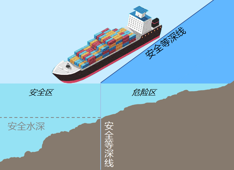
In the chart display, the safe isobath is usually represented by a thick line. The light side of the line is a safe area suitable for ships to pass through, while the dark side of the line is a dangerous area, which is usually not recommended for ships to enter. In both two-color and four-color, the safety isobath plays a crucial role.
The safety isobath is the most critical water depth parameter, which distinguishes the safe area from the dangerous area and is the main reference for ship navigation.Shallow Contour
Although the water depth in these areas is less than safe isobath, ships can navigate briefly in certain circumstances, such as close to a port or narrow channel. The display of shallow water isobaths helps navigators to identify these potential navigation areas, so as to flexibly cope with various navigation environments.
Shallow water isobaths are displayed in Four-Color, identifying a buffer area between the safe isobath and shallower water.Deep Contour
These areas are shown in the lightest color under Four-Color, indicating that this is a safe driving area. The navigator can adjust the value of the deep water isobath according to his needs, for example, setting it to the maximum water depth that can be safely anchored, so as to meet the specific navigation needs.
The deep water isobath is usually set at twice the ship's actual draft to identify the deep water area.
 |
 |
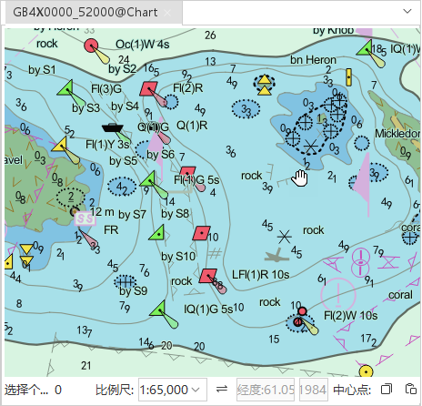
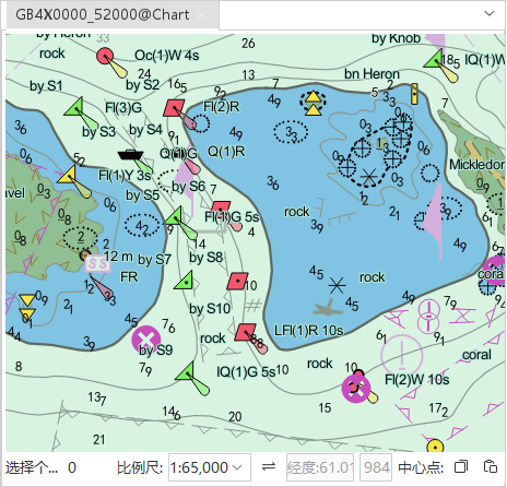
| Chart Depth Settings Parameters-Four-Color | Chart Depth Settings Parameters-Two Shades |
By adjusting these parameters, navigators can optimize the display of water depth information in Electronic Chart according to different navigation needs and environmental conditions, thus improving the safety and efficiency of navigation. These settings have different application scenarios in open and complex waters, ensuring effective navigation support in various navigation conditions.
Operation steps
- Chart Panel -& > Nautical Chart Properties Group -& > Nautical Chart Properties
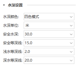
- On the Nautical Chart Properties panel popped up on the right side of Workspace, set the water depth display of the current chart in the Depth Settings group, including water depth unit, safe water depth, safe isobath, shallow water isobath, deep water isobath, etc.
 |
| Properties Panel "Depth Settings" group |
Parameter Description
- Water Depth Color
- Two Shades: Two shades of color divided by safety isobath; characterized by clarity and suitable for use in open water.
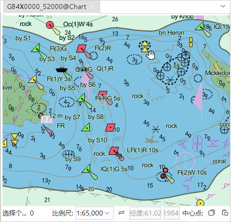
- Four-Color: Four colors are divided by "3 isobaths"; although Four-Color increases the difficulty of reading, it is more informative and suitable for use in complex waters.
 |
 |
| Display Effects for Two Shades | Display Effects for Four-Color |
- Water depth unit: Select the unit of water depth displayed on the chart in the drop-down list. Units are decimeter, meter, inch.
- Safe water depth: Select the value of water depth point in the drop-down list; or directly input the value of safe water depth in the combo box.
- Safe depth contour: Select the value of safe depth contour in the drop-down list; or directly enter the value of safe depth contour in the combo box.
 |
 |
| Display Effects with 5 m safety isobath | Display Effects with a safe isobath of 20 meters |
- Shallow bathymetric line: Select the value of shallow bathymetric line in the drop-down list; or directly enter the value of shallow bathymetric line in the combo box.
- Deep water isobath: Select the value of the deep water isobath in the drop-down list; or directly enter the value of the deep water isobath in the combo box.
 Hint:
Hint: set, if it is necessary to Display Soundings in Map (the dangerous water depth points less than safe water depth are in bold black), the Nautical Chart Properties panel -& gt; In Filter Settings - Element Settings, check " Display Soundings". For more information about Filter Settings, see Filter Show Settings .
Related topics